Derinkuyu underground city
The Derinkuyu underground city (Cappadocian Greek: Μαλακοπή) is an ancient multi-level underground city in the Derinkuyu district in Nevşehir Province, Turkey. Extending to a depth of approximately 60 m (200 feet), it is large enough to have sheltered as many as 20,000 people together with their livestock and food stores. It is the largest excavated underground city in Turkey and is one of several underground complexes found across Cappadocia.
It was opened to visitors in 1969 and about half of the underground city is currently accessible to tourists.
Features
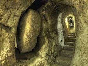
The underground city at Derinkuyu could be closed from the inside with large stone doors. Each floor could be closed off separately.
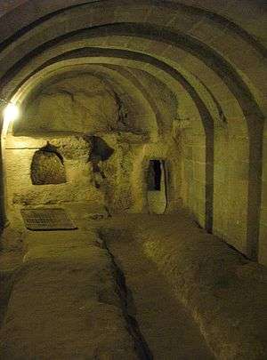
The city could accommodate as many as 20,000 people and had all the usual amenities found in other underground complexes across Cappadocia, such as wine and oil presses, stables, cellars, storage rooms, refectories, and chapels. Unique to the Derinkuyu complex and located on the second floor is a spacious room with a barrel vaulted ceiling. It has been reported that this room was used as a religious school and the rooms to the left were studies.[1]
Between the third and fourth levels is a vertical staircase. This passageway leads to a cruciform church on the lowest (fifth) level.
The large 55 m (180 foot) ventilation shaft appears to have been used as a well. The shaft also provided water to both the villagers above and, if the outside world was not accessible, to those in hiding.
History
Caves may have been built initially in the soft volcanic rock of the Cappadocia region by the Phrygians, an Indo-European people, in the 8th–7th centuries B.C., according to the Turkish Department of Culture.[2] When the Phrygian language died out in Roman times, replaced with its close relative,[3] the Greek language,[4] the inhabitants, now Christian, expanded their underground caverns adding the chapels and Greek inscriptions.
The city at Derinkuyu was fully formed in the Byzantine era, when it was heavily used as protection from Muslim Arabs during the Arab–Byzantine wars (780-1180).[5][6] It was at this time that most of the chapels and Greek inscriptions were added. The city was connected with other underground cities through miles of tunnels. Some artifacts discovered in these underground settlements belong to the Middle Byzantine Period, between the 5th and the 10th centuries A.D.
These cities continued to be used by the Christian natives as protection from the Mongolian incursions of Timur in the 14th century.[7][8]
After the region fell to the Ottomans, the cities were used as refuges (Cappadocian Greek: καταφύγια) from the Turkish Muslim rulers.[9] As late as the 20th century the locals, called Cappadocian Greeks, were still using the underground cities to escape periodic waves of Ottoman persecution.[9] R. M. Dawkins, a Cambridge linguist who conducted research on the Cappodocian Greek natives in the area from 1909-1911, recorded that in 1909, "when the news came of the recent massacres at Adana, a great part of the population at Axo took refuge in these underground chambers, and for some nights did not venture to sleep above ground."
When the Christian inhabitants of the region were expelled in 1923 in the population exchange between Greece and Turkey the tunnels were abandoned.[6][10]
The tunnels were rediscovered in 1963, after a resident of the area found a mysterious room behind a wall in his home. Further digging revealed access to the tunnel network.[11]
Other underground cities
Nevşehir Province has several other historical underground cities and Derinkuyu connects to Kaymakli via an 8 km (five mile) tunnel .
The underground cities and structures are carved out of unique geological formations. They may have been used as hiding places during times of raids. The locations are now archaeological tourist attractions. They remain generally unoccupied. In excess of 200 underground cities containing a minimum of two levels have been discovered in the area between Kayseri and Nevsehir. Some 40 of those contain a minimum of three levels or more. The cities at Kaymaklı and Derinkuyu are two of the best examples of habitable underground structures .
See also
- Avanos
- Churches of Göreme, Turkey
- Derinkuyu
- Eskigümüş Monastery
- Ihlara Valley
- Kaymaklı Underground City
- Mokissos
- Özkonak Underground City
- Population exchange between Greece and Turkey
- Zelve Monastery
- Nooshabad underground city, Iran
References
- ↑ Nevşehir > Underground Settlements > Derinkuyu Underground City
- ↑ Turkish Department of Culture
- ↑ Woodard, Roger D. The Ancient Languages of Asia Minor. Cambridge University Press, 2008, ISBN 0-521-68496-X, p. 72. "Unquestionably, however, Phrygian is most closely linked with Greek."
- ↑ Swain, Simon; Adams, J. Maxwell; Janse, Mark (2002). Bilingualism in Ancient Society: Language Contact and the Written Word. Oxford [Oxfordshire]: Oxford University Press. pp. 246–266. ISBN 0-19-924506-1.
- ↑ Horrocks, Geoffrey C. (2010). Greek: A History of the Language and Its Speakers. John Wiley & Sons. p. 403. ISBN 978-1-4051-3415-6.
None the less, at the beginning of the 20th century, Greek still had a strong presence in Silli north-west of Konya (ancient Ikonion), in Pharasa and other villages in the region drained by the Yenice river (some 100km south of Kayeri, ancient Caesarea), and in Cappadocia proper, at Arabison (Arapsu/Gulsehir) north-west of Nevsehir (ancient Nyssa), and in the large region south of Nevsehir as far down as Nigde and Bor (close to ancient Tyana). This whole area, as the home of St Basil the Great (329-79), his brother St Gregory of Nyssa (335-94) and his friend St Gregory of Nazianzos (330-89), was of great importance in the early history of Christianity, but is perhaps most famous today for the extraordinary landscape of eroded volcanic tufa in the valleys of Goreme, Ihlara and Soganh, and for the churches and houses carved into the ‘fairy chimneys’ to serve the Christian population in the middle ages. Many of the rock cut churches, which range in date from the 6th to the 13th centuries, contain magnificent frescos. Away from the valleys, some of the villages have vast underground complexes containing houses, cellars, stables, refectories, cemeteries and churches, affording protection from marauding Arabs in the days when the Byzantine empire extended to the Euphrates, and serving later as places of refuge from hostile Turkish raiders. The most famous of these are at Kaymakli and Derinkuyu, formerly the Greek villages of Anaku (Inegi) and Malakopi (Melagob), where the chambers extended down over several levels of depths of up to 85 metres.
- 1 2 Darke, Diana (2011). Eastern Turkey. Bradt Travel Guides. pp. 139–140. ISBN 978-1-84162-339-9.
The area became an important frontier province during the 7th century when Arab raids on the Byzantine Empire began. By now the soft tufa had been tunneled and chambered to provide underground cities where a settled if cautious life could continue during difficult times. When the Byzantines re-established secure control between the 7th and 11th centuries, the troglodyte population surfaced, now carving their churches into rock faces and cliffs in the Goreme and Sogamli areas, giving Cappadocia its fame today. […] At any rate here they flourished, their churches remarkable for being cut into the rock, but interesting especially for their paintings, relatively well preserved, rich in coloring, and with an emotional intensity lacking in the formalism of Constantinople; this is one of the few places where paintings from the pre-iconoclastic period have survived. Icons continued to be painted after the Seljuk conquest of the area in the 11th century, and the Ottoman conquest did not interfere with the Christian practices in Cappadocia, where the countryside remained largely Greek, with some Armenians. But decline set in and Goreme, Ihlara and Soganli lost their early importance. The Greeks finally ending their long history here with the mass exchange of populations between Turkey and Greece in 1923.
- ↑ Kinross, Baron Patrick Balfour (1970). Within the Taurus: a journey in Asiatic Turkey. J. Murray. p. 168. ISBN 978-0-7195-2038-9.
Its inhabitants were Cappadocian Greeks, who may have found a refuge here, perhaps from Roman, from Iconoclast, or later from Turkish and Mongol threats. Urgup itself was the Byzantine Prokopion; the Emperor Nicephoros Phocas is said to have passed this way, after his Cilician campaign; and the neighborhood was populous enough to support, at different times, a number of bishoprics.
- ↑ Dawkins, R. M. (1916). Modern Greek in Asia Minor. A study of dialect of Silly, Cappadocia and Pharasa. Cambridge University Press. p. 17. Retrieved 25 October 2014.
these excavations are referred to as long ago as the campaigns of Timour Beg, one of whose captains was sent to hunt out the inhabitants of Kaisariyeh, who had taken refuge in their underground dwellings, and was killed by an arrow shot through the hole in one of the doors.
- 1 2 Dawkins, R. M. (1916). Modern Greek in Asia Minor. A study of dialect of Silly, Cappadocia and Pharasa. Cambridge University Press. p. 16. Retrieved 25 October 2014.
their use as places of refuge in time of danger is indicated by their name καταφύγια, and when the news came of the recent massacres at Adana [in 1909], a great part of the population at Axo took refuge in these underground chambers, and for some nights did not venture to sleep above ground.
- ↑ Rodley, Lyn (2010). Cave Monasteries of Byzantine Cappadocia. Cambridge University Press. p. 1. ISBN 978-0-521-15477-2.
The tenth-century historian Leo the Deacon records a journey to Cappadocia made by Nikephoros Phokas shortly before he became emperor. Perhaps to recapture the attention of readers beginning to tire of troop movements he also offers a scrap of information about a curiosity of the region to which the emperor was heading: its inhabitants were once called troglodytes, because ‘they went underground in holes, clefts and labyrinths, as it were in dens and burrows’. This brief note was probably not based on first-hand knowledge but it might have been prompted by an awareness of the vast number of rock-cut cavities in an area to the west and southwest of Kaisareia (Kayseri of modern Turkey). Had Leo been more inclined to garrulous digression (or perhaps just better informed), he might have supplied more details of the troglodyte region and the task of bringing scholarly order to the hundreds of rock-cut monuments and other cavities in the area might have been much similar. … At this time the region was still inhabited by a mixed population of Turkish-speaking Moslems and Greek-speaking Christians. The latter group left for Greece in the early 1920s, during an exchange of population of minorities that was part of the radical social re-ordering initiated by Kemal Ataturk; they were replaced by Turks from Greece, mostly from Thrace. In the two decades before this upheaval, however, members of the local Greek population acted as guides to Guillaume de Jerphanion, who made several visits to the volcanic valleys and wrote his meticulous descriptions of many painted Byzantine rock-cut churches.
- ↑ Sometimes Interesting. "Derinkuyu & The Underground Cities of Cappadocia". Sometimes Interesting. Retrieved March 29, 2015.
Further reading
- Spiro Kostof, Caves of God: Cappadocia and its Churches Publisher: Oxford University Press, 1989 ISBN 0-19-506000-8 ISBN 978-0195060003
External links
| Wikimedia Commons has media related to Derinkuyu. |
- Cavetowns and gorges of Cappadocia
- Underground Cities of Cappadocia - Myth and Truth(in German)
- Derinkuyu Underground City
- Derinkuyu & The Underground Cities of Cappadocia Sometimes Interesting. 9 May 2014
Coordinates: 38°22′25″N 34°44′06″E / 38.3735°N 34.7351°E