Dhamtari
| Dhamtari धमतरी | |
|---|---|
| city | |
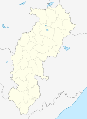 Dhamtari  Dhamtari Location in Chhattisgarh | |
| Coordinates: IN 20°43′N 81°33′E / 20.71°N 81.55°ECoordinates: IN 20°43′N 81°33′E / 20.71°N 81.55°E | |
| Country | India |
| District | Dhamtari |
| Elevation | 317 m (1,040 ft) |
| Population (2001) | |
| • Total | 82,099 |
| Time zone | IST (UTC+5:30) |
| PIN | 493773, 4936XX,4937XX |
| Vehicle registration | CG |
| Website | www.dhamtari.gov.in |
Dhamtari is a municipal corporation [1] and district in the state of Chhattisgarh, India, which is part of the Mahasamund Lok Sabha constituency formed on 6 July 1998.. The district is home to 3.13 percent of Chhattisgarh's total population.
History
.jpg)
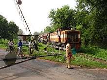
Dhamtari's population was 17,278 in 1955. At that time, the town was part of Raipur District in the state of Madhya Pradesh. In 2000, it became part of the new Chhattisgarh state and headquarters for the Dhamtari tehsil. As a terminus of a narrow-gauge railway running 80 km (50 miles) north of Raipur on the main Bombay-Calcutta line of the Bengal Nagpur Railway, Dhamtari became a trade centre. Goods shipped from there included timber, shellac, morabulum nuts, beedi leaves(for cigarettes), rice and animal hides.
The American Mennonite Mission was established in Dhamtari in 1899. By 1952 the mission had merged with the Mennonite Church (MC) in India, which had its headquarters in Dhamtari. In 1955 the 558-member congregation was one of several missionary groups in Dhamtari, including the Dhamtari Christian Academy, Dhamtari Christian Hospital,[2] the Samuel Burkhard Memorial Boys' Orphanage and a nursing school. The community of Marathapara, in Dhamtari, comprises the world's largest population of MarathasAt the present Dhamtari is a "Nagar Nigam" .
Geography
Dhamtari is in the fertile plains of Chhattisgarh. The district's total area is 2,029 square kilometres (783 sq mi), and it is about 317 meters (1,040 feet) above sea level. It is bordered by the Raipur District to the north, the Kanker and Bastar Districts to the south, the State of Orissa to the east and the Durg and Kankar Districts to the west. The fertility of the land in the Dhamtari District is due to the Mahanadi River and its tributaries (Sendur, Pairy, Sondur, Joan, Kharun, and Shivnath).dhamtari is situated 65 km from capital raipur.
Economy
Lead deposits exist in the district. Most of the city's workforce is involved in the timber industry or rice or flour milling (Dhamtari has more than 100 rice mills), with the chemical industry also a significant presence. The Ravishankar Sagar Dam irrigates nearly 57,000 hectares (140,000 acres) of land, and is the primary supplier of potable water to the state capital of Raipur and the steel plant at Bhilai. The dam is about 11 kilometres (6.8 mi) from the district capital. Asia's first siphon dam was built in 1914 at Madamsilli; the Sondhur and Dudhawa Dams are other important works.
Transportation
Dhamtari is serviced by several forms of public transportation, including luxury buses, tempos and auto-rickshaws. The Raipur-Dhamtari narrow-gauge line also provides service to the area.
Education
Schools
- Nutan Higher Secondary School
- Govt. Boys Higher Secondary School
- Govt. Girls Higher Secondary School
- Hari Ohm Higher Secondary School
- Saraswati Shishu Mandir Higher Secondary School
- Mennonite Senior Secondary School
- Anjuman Higher Secondary School
- Model English School
- Delhi Public School
- St. Xaviers School
- Vidya Kunj
- Kendriya Vidyalaya
- Saraswati Shishu Vidya Mandir
Colleges
- Vandematarm College Ganesh Chowk Dhamtari
- Comp-Tech Degree College
- Govt. P.G. College
- Govt. Polytechnic College
- Govt. Girls College
- Genesis College
- Kl Collge of Horticulture
Healthcare
- Dhamtari Christian Hospital (DCH)
- Dhamtari District Hospital (DDH)
Places of interest
Dhamtari is known for its traditional folk culture. Among the district's points of interest is the Ravishankar Water Dam (also known as the Gangrel Dam), noted for its sunsets. The dam attracts tourists from Chhattisgarh and other states, especially when it overflows during the monsoon. The Sitanadi Wildlife Sanctuary, a popular tourist attraction, is a tiger reserve. [3]
External links
References
- ↑ "Dhamtari Municipal Corporation". dailypioneer.com. Retrieved 2014-08-14.
- ↑ "Dhamtari Christian Hospital". Mennonite Mission Network. Retrieved 19 January 2014.
- ↑ "Sitanadi Wildlife Sanctuary". www.tourismofchhattisgarh.com. Retrieved 2014-05-13.