Dirkou Airport
| Dirkou Airport | |||||||||||
|---|---|---|---|---|---|---|---|---|---|---|---|
| IATA: none – ICAO: DRZD | |||||||||||
| Summary | |||||||||||
| Airport type | Public | ||||||||||
| Serves | Dirkou | ||||||||||
| Elevation AMSL | 1,273 ft / 388 m | ||||||||||
| Coordinates | 18°58′10″N 12°52′10″E / 18.96944°N 12.86944°ECoordinates: 18°58′10″N 12°52′10″E / 18.96944°N 12.86944°E | ||||||||||
| Map | |||||||||||
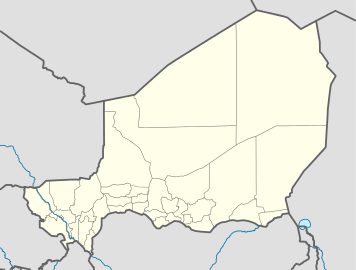 DRZD Location of the airport in Niger | |||||||||||
| Runways | |||||||||||
| |||||||||||
|
Source: Google Maps[1] | |||||||||||
Dirkou Airport (ICAO: DRZD) is an airport serving Dirkou, Niger. It is 2 kilometres (1.2 mi) southwest of the city center.
See also
- Transport in Niger
 Niger portal
 Aviation portal
References
This article is issued from Wikipedia - version of the 12/4/2016. The text is available under the Creative Commons Attribution/Share Alike but additional terms may apply for the media files.