Discovery Island Marine Provincial Park
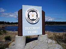
Discovery Island Marine Provincial Park is a provincial park located about two nautical miles east of Oak Bay on the coast of British Columbia. It is about a mile long and one-half mile wide and looks out into the Juan de Fuca Strait.
Discovery Island Marine Provincial Park is only accessible by boat and is popular with kayakers. The nearest marina and official anchorage is located in Oak Bay and the nearest launching ramp is located at Cattle Point. On the east side of the island on Pandora Hill there is a lighthouse which has been automated for the past several years. Pandora Hill is also one of the turning points for the Canada–United States border. The northern portion of Discovery Island is a First Nations reserve.
Camping is allowed in the area southwest of Pandora Hill. Campers can set up a tent (CA$5 per person per night). There is a pit toilet, and there are picnic tables, however, there is no drinking water on the island and it is a pack-in-pack-out campsite. Rudlin Bay is the main access to the campground which is filled with dangerous rocks as well as being exposed to the southeast however it is possible for a small boat to temporarily anchor there, however, there is no safe overnight anchorage. Campfires are not permitted on Discovery Island.
-
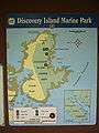
The map on display at the campground.
-
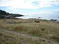
The view from the campground.
See also
References
- This article contains text copied from discoveryisland.ca, a source released under the licensing terms of GFDL
External links
Coordinates: 48°25′N 123°14′W / 48.417°N 123.233°W