Doab
| Doab دوآب / दोआब | |
|---|---|
| Natural region | |
|
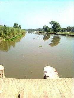
View of a canal in the lower Bari Doab of the Punjab Doabs | |
| Country | Pakistan and India |
Doab (Urdu: دوآب, Hindi: दोआब,[1] from Persian: دوآب dōāb, from dō, "two" + āb, "water" or "river") is a term used in India and Pakistan for the "tongue,"[2] or tract of land lying between two converging, or confluent, rivers. It is similar to an interfluve.[3] In the Oxford Hindi-English Dictionary, R. S. McGregor defines it as "a region lying between and reaching to the confluence of two rivers (esp. that between the Ganges and Jumna)."[1]
Doab
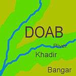
Since North India and Pakistan are coursed by a multiplicity of Himalayan rivers that divide the plains into doabs (i.e. regions between two rivers), the Indo-Gangetic plains consist of alternating regions of river, khadir and bangar. The centres of the doabs consist of low-lying flood-prone bangar and the higher-lying peripheries which line the rivers, consist of khadir.[4]
Historically, villages in the doabs have been officially classified as khadir, khadir-bangar (i.e. mixed) or bangar for many centuries and different agricultural tax rates applied based on a tiered land-productivity scale.[5][6]
United Provinces Doab
The United Provinces Doab, covers the current Uttar Pradesh and Uttrakhand states is unqualified by the names of any rivers, designates the flat alluvial tract between the Ganges and Yamuna rivers extending from the Sivalik Hills to the two rivers' confluence at Allahabad. The region has an area of about 23,360 square miles (60,500 square km); it is approximately 500 miles (805 km) in length and 60 miles (97 km) in width.
The region of the Doab figures prominently in the history and myths of Vedic period. The British divided the Doab into three administrative districts or zones, viz., Upper Doab (Meerut), Middle Doab (Agra) and Lower Doab (Allahabad). These districts are now divided into several other districts as enumerated below.
The following districts/states form part of the Doab:
Upper Doab
Dehradun, Haridwar, Rishikesh, Muzaffarnagar, Saharanpur, Meerut, Ghaziabad, Gautam Buddh Nagar, Bulandshahr and Delhi.
Central or Middle Doab
Etah, Kasganj, Aligarh, Agra, Hathras, Firozabad, Farrukhabad, Kannauj, Mainpuri, Etawah, Auraiya and Mathura. Mathura is in the trans-Yamuna region of Braj.
Lower Doab
Kanpur, Fatehpur, Kaushambi and Allahabad.
The Punjab Doabs
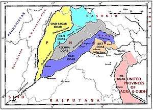
Each of the tracts of land lying between the confluent rivers of the Punjab region of Pakistan and India has a distinct name, said to have been coined by Raja Todar Mal, a minister of the Mughal emperor Akbar. The names (except for 'Sindh Sagar') are a combination of the first letters, in the Persian alphabet, of the names of the rivers that bound the Doab. For example, Jech = 'Je'(Jhelum) + 'Ch'(Chenab). The names are (from west to east):
Sind Sagar Doab
The Sind Sagar Doab lies between the Indus and Jhelum rivers.
Jech Doabs
The Jech Doab (also Chaj Doab) (small portion of the Jech Doab is Majha[7]) lies between the Jhelum and the Chenab rivers.
Rechna Doabs
The Rechna Doab (considerable portion of the Rechna Doab is Majha[7]) lies between the Chenab and the Ravi rivers.
Bari Doabs
The Bari Doab (considerable portion of the Bari Doab is Majha[7]) lies between the Ravi and the Beas rivers.
Bist Doab
The Bist Doab (or Doaba) - between the Beas and the Sutlej rivers.
Other Doabs
In addition, the tract of land lying between the Sutlej and the Yamuna river is sometimes called the Delhi doab, although, strictly speaking, it is not a doab, since its two bounding rivers, the Yamuna and Sutlej, are not confluent.
Malwa Doab
The rivers flowing through the Malwa region, covering current states of Madhya Pradesh and parts of north-eastern Rajasthan, also has doab region such as Upper Malwa doab and Lower Malwa doab.
Raichur Doab
The Raichur Doab is the triangular region of Andhra Pradesh and Karnataka states which lies between the Krishna River and its tributary the Tungabhadra River, named for the town of Raichur.
See also
Notes
- 1 2 McGregor 1993, p. 513.
- ↑ doab or duab, n., OED Online, Oxford University Press, September 2013, retrieved 11 September 2013
- ↑ Doab., Webster's Third New International Dictionary, Unabridged., 2013, retrieved 11 September 2013
- ↑ Pakistan: Soils, Encyclopædia Britannica, 2010,
... khaddar soils. Away from the river, toward the middle of the doabs, older alluvial soils (called bangar) are widely distributed ...
- ↑ F.C. Channing, Land Revenue Settlement of the Gurgaon District, Government of India,
... The rates here applied were the same as those applied in the Bangar and Khadar circles and the same comparisons hold good ...
- ↑ Oswald Wood, R. Maconachie, Final report on the settlement of land revenue in the Delhi District, Government of India, 1882,
... The Khadar-Bangar chak lies along the river; 37 villages are purely Khadar and 39 partly Khadar partly Bangar. The villages nearest the river are subject to inundations, but where the water runs off in time, the natural fertility of the ...
- 1 2 3 Kakshi, S.R.; Pathak, Rashmi; Pathak, S.R.Bakshi R. (2007-01-01). Punjab Through the Ages. Sarup & Sons. ISBN 978-81-7625-738-1. Retrieved 12 June 2010.
References
- McGregor, Ronald Stuart (1993), The Oxford Hindi-English Dictionary, Oxford University Press, p. 513, ISBN 978-0-19-864339-5, retrieved 11 September 2013