Dodge Center Airport
| Dodge Center Municipal Airport | |||||||||||||||
|---|---|---|---|---|---|---|---|---|---|---|---|---|---|---|---|
 | |||||||||||||||
| IATA: --- – ICAO: KTOB – FAA LID: TOB | |||||||||||||||
| Summary | |||||||||||||||
| Airport type | Public | ||||||||||||||
| Owner | City of Dodge Center | ||||||||||||||
| Location | Dodge Center, Minnesota | ||||||||||||||
| Elevation AMSL | 1,305 ft / 398 m | ||||||||||||||
| Coordinates | 44°1′5″N 92°50′4″W / 44.01806°N 92.83444°W[1]Coordinates: 44°1′5″N 92°50′4″W / 44.01806°N 92.83444°W[2] | ||||||||||||||
| Map | |||||||||||||||
 TOB  TOB Location of airport in Minnesota/United States | |||||||||||||||
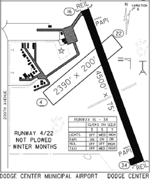
| Runways | |||||||||||||||
| |||||||||||||||
Dodge Center Municipal Airport (IATA: ---, ICAO: KTOB, FAA LID: TOB) is a public airport located one mile from the central business district of Dodge Center a city in Dodge County, Minnesota, United States. The airport is publicly owned by the city of Dodge Center.
References
This article is issued from Wikipedia - version of the 10/23/2016. The text is available under the Creative Commons Attribution/Share Alike but additional terms may apply for the media files.