Double Ditch
|
Double Ditch State Historic Site | |
 | |
  | |
| Nearest city | Bismarck, North Dakota |
|---|---|
| Area | 37.5 acres (15.2 ha) |
| NRHP Reference # | 79001769, 14000896[1] |
| Added to NRHP | January 29, 1979 |
Double Ditch, also known as the Double Ditch State Historic Site, Burgois Site, 32BL8, Bourgois Site, and Double Ditch Earth Lodge Village Site, is an archaeological site located along the Missouri River north of Bismarck, North Dakota, United States. It earns its name from the two visible earth mounds that outline the site, but archaeological survey found that there are four ditches total.[2]

The site was the location of a Mandan Native American earth lodge village from approximately 1490 A.D. to 1785 A.D. The village is estimated to have had a population of 10,000 or more persons. Archaeological survey of the site using radio gradiometry techniques revealed two additional ditches that were constructed in the late 15th century and is now considered one of the oldest prehistoric settlements in the area.[2] It was abandoned after the 1775–1782 North American smallpox epidemic.[3] After the epidemic, the Mandan tribe banded together with the Hidatsa and created Like-a-Fishhook Village in 1845.[4] The site includes remains of earth lodges, midden mounds, and fortification ditches. It is managed by the State Historical Society of North Dakota.
The site is the subject of two listings on National Register of Historic Places: one for its archaeological significance in 1979, the other for its Depression-era park structures in 2014.[1]
Overview


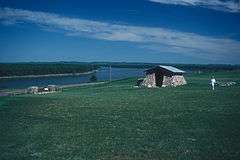
The Mandans built dome-shaped houses of logs and earth, known as earth-lodges.[5] The raised areas around the village are midden mounds or earthen mounds ranging from one to ten feet high. There are more than 30 mounds surrounding the village. Fortification systems consisted of a deep moat and a wall of wooden posts that formed a palisade. Natural features, such as steep terrain and riverbanks, also were used for added protection.[5]
See also
- Chief Looking's Village site (32BL3), also a Heart River Mandan village site, also NRHP-listed
References
- 1 2 National Park Service (2010-07-09). "National Register Information System". National Register of Historic Places. National Park Service.
- 1 2 http://onlinelibrary.wiley.com/doi/10.1002/arp.325/pdf
- ↑ "Double Ditch Indian Village". State Historical Society of North Dakota. Retrieved August 7, 2012.
- ↑ Mandan#Origins and early history
- 1 2 "Double Ditch Indian Village - History - State Historical Society of North Dakota". history.nd.gov. Retrieved 2016-01-08.
External links
- Double Ditch Indian Village
- U.S. Geological Survey Geographic Names Information System: Double Ditch Indian Village
| Topics | |
|---|---|
| Lists by states |
|
| Lists by insular areas | |
| Lists by associated states | |
| Other areas | |
| |
Coordinates: 46°56′11″N 100°54′03″W / 46.93639°N 100.90083°W