Dover to Clarksville Road-Hickeytown Road Segment
|
Dover to Clarksville Road Road-Hickeytown Road Segment | |
 | |
  | |
| Nearest city | Lamar, Arkansas |
|---|---|
| Coordinates | 35°25′8″N 93°7′18″W / 35.41889°N 93.12167°WCoordinates: 35°25′8″N 93°7′18″W / 35.41889°N 93.12167°W |
| Area | 9.9 acres (4.0 ha) |
| MPS | Cherokee Trail of Tears MPS |
| NRHP Reference # | 05000464[1] |
| Added to NRHP | May 26, 2005 |
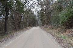
The Dover to Clarksville Road-Hickeytown Road Segment is a historic road section southeast of Lamar, Arkansas. It consists of a 1.3-mile (2.1 km) gravel section of Old Hickeytown Road, beginning at its junction with County Road 2651. The road bed is about 17 feet (5.2 m) wide, and lined with ditches on either side. The western portion of the road, while paved, exhibits similar characteristics. The road's date of construction is not known, but it likely dates to the 1830s or early 1840s, based on its design. It was probably used by a party of Cherokee in 1834, during the Trail of Tears forced migration.[2]
The road section was listed on the National Register of Historic Places in 2005.[1]
See also
References
- 1 2 National Park Service (2010-07-09). "National Register Information System". National Register of Historic Places. National Park Service.
- ↑ "NRHP nomination for Dover to Clarksville Road-Hickeytown Road Segment" (PDF). Arkansas Preservation. Retrieved 2016-05-10.
| Topics | |
|---|---|
| Lists by states |
|
| Lists by insular areas | |
| Lists by associated states | |
| Other areas | |
| |
This article is issued from Wikipedia - version of the 12/2/2016. The text is available under the Creative Commons Attribution/Share Alike but additional terms may apply for the media files.