Dugandan railway line
| Dugandan railway line | |||||||||||||||||||||||||||||||||||||||||||||||||||||||||||||||||||||||||||||||||||||||||||||||||||||||||||||||||||||||||||||||||||||||||||||||||
|---|---|---|---|---|---|---|---|---|---|---|---|---|---|---|---|---|---|---|---|---|---|---|---|---|---|---|---|---|---|---|---|---|---|---|---|---|---|---|---|---|---|---|---|---|---|---|---|---|---|---|---|---|---|---|---|---|---|---|---|---|---|---|---|---|---|---|---|---|---|---|---|---|---|---|---|---|---|---|---|---|---|---|---|---|---|---|---|---|---|---|---|---|---|---|---|---|---|---|---|---|---|---|---|---|---|---|---|---|---|---|---|---|---|---|---|---|---|---|---|---|---|---|---|---|---|---|---|---|---|---|---|---|---|---|---|---|---|---|---|---|---|---|---|---|---|
Legend
| |||||||||||||||||||||||||||||||||||||||||||||||||||||||||||||||||||||||||||||||||||||||||||||||||||||||||||||||||||||||||||||||||||||||||||||||||
The Dugandan railway line was a branch railway in the Scenic Rim region of South East Queensland, Australia.
The line began west of Ipswich station on the Main Line 39 km west of Brisbane and proceeded generally southward for approximately 50 km to the locality of Dugandan now part of the urban settlement of Boonah.
Residents in the Fassifern Valley petitioned the Queensland government to build a railway line to their district, and the first section was opened in 1882 as far as Harrisville. This is considered to be Queensland's first branch railway. The branch was completed to Dugandan in September 1887.[1]
The Mount Edwards branch line branched off the Dugandan line at Munbilla. The Mount Edwards line operated from 1922 to 1960.[2][3]
During its life, the Dugandan branch carried mixed traffic, including goods trains, mixed trains and rail motors.[1]
The Dugandan branch was closed in June 1964 due to increasing competition from road transport.[1]
Some evidence of the line's existence remains today. An embankment which carried the railway over a floodplain immediately north of Boonah is still readily visible from the Boonah-Fassifern Road. The station building at Harrisville is still intact, as is a small cutting immediately south of Harrisville station. Part of the alignment between Boonah and Dugandan along a cut-and-fill embankment is now a paved footpath through an urban park.
The Scenic Rim Region is currently developing a rail trail in partnership with the Queensland state government. The trail for the use of bushwalkers, cyclists and horse riders will follow some of the former alignment between Ipswich and Boonah.[4]
Gallery
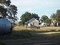 Harrisville railway station
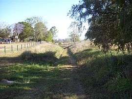 Shallow railway cutting in Harrisville
 Former track formation between Boonah and Dugandan with a cutting on the right, now a footpath through a park
See also
References
- 1 2 3 Johnson, M.; Saunders, K. (2007). "Working The Land: An historical overview of Boonah and its northern district" (PDF). State of Queensland. Retrieved 2009-10-24.
- ↑ QR Limited. "Rail as foremost mode of travel". Retrieved 2009-10-25.
- ↑ Southern Downs Steam Railway (2009). "'Via recta' - The line that never was". Retrieved 2009-10-25.
- ↑ Scenic Rim Region. "SEQ Regional Recreational Trails Program". Retrieved 2009-10-25.
External links
| Wikimedia Commons has media related to Dugandan railway line. |
| |||||||
| |||||||
|