Dunmere, Cornwall
Coordinates: 50°28′38″N 4°45′10″W / 50.4771°N 4.7527°W
Dunmere is a hamlet in Cornwall, England, United Kingdom. It is situated one mile northwest of Bodmin in the valley of the River Camel[1] on the A389 road.
The former branch of the Bodmin and Wenford Railway to Wenfordbridge crossed the A389 road at Dunmere. This section of the railway now forms part of the Camel Trail, a long-distance footpath and cycle trail.
Boscarne Junction railway station, the current terminus of the railway, is situated a mile (1.6 km) west of Dunmere.
Dunmere has a pub, The Borough Arms.
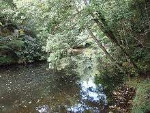
The River Camel at Dunmere Weir
References
- ↑ Ordnance Survey: Landranger map sheet 200 Newquay & Bodmin ISBN 978-0-319-22938-5
Cornwall Portal | |
| Unitary authorities | |
| Major settlements |
|
| Rivers | |
| Topics | |
This article is issued from Wikipedia - version of the 1/23/2016. The text is available under the Creative Commons Attribution/Share Alike but additional terms may apply for the media files.