Dzherginsky Nature Reserve
| Dzherginsky Nature Reserve | |
|---|---|
| Russian: Джергинский заповедник | |
|
IUCN category Ia (strict nature reserve) | |
|
Dzherginsky Zapovednik | |
 Location of Reserve | |
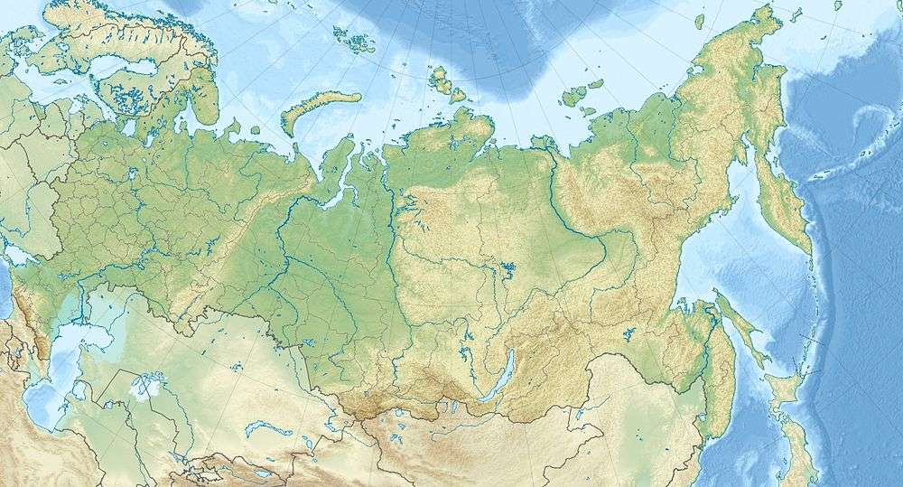
| Location | Buryatia |
| Nearest city | Ulan-Ude |
| Coordinates | 55°6′51″N 111°27′32″E / 55.11417°N 111.45889°ECoordinates: 55°6′51″N 111°27′32″E / 55.11417°N 111.45889°E |
| Area | 238,088 hectares (588,330 acres) |
| Established | 1992 |
| Governing body | Ministry of Natural Resources and Environment (Russia) |
| Website | http://www.barguzin-istok.ru/ |
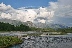
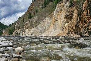
Dzherginsky Nature Reserve (Russian: Джергинский заповедник) is a Russian 'zapovednik' (strict nature reserve), located about 100 km east of the northern section of Lake Baikal. It covers the source and upper reaches of the Barguzin River, the second largest tributary to Lake Baikal, and is at the junction of three mountain ranges - the Barguzin Range to the west of the reserve, the Ikat Range and the South Muya Ridge. The reserve's mountainous territory is dominated by larch forests. It is situated in the Kurumkansky District of Buryatia. The nearest city, Ulan-Ude, is 560 km to the south.[1][2] The reserve was formally established in 1992 to protect the biodiversity of the upper Barguzin valley, and to study natural processes of the area. It covers an area of 238,088 hectares (919.26 sq mi).
Topography
The Dzherginsky Reserve covers both mountains and river valleys. The upper Barguzin River valley begins in the southwest of the reserve, the Barguzin Range enters the reserve from the west, the Ikat Range to the east. The territory also covers parts of the South Muya Ridge and the Amutskaya Basin. The valleys and river basins are generally oriented towards the northeast. Glacial origin is evidenced by cirques and lateral moraines in the Barguzin valley. The Barguzin Ridge itself has not been subject to glaciation. The Ikat Ridge (350 km long and up to 100 km wide) intersects the South Muya Ridge within the boundaries of Dzherginsky, and reaches a height of 2,500 m (8,200 ft).[2]
Climate and Ecoregion
Dzherginsky is located in the East Siberian taiga ecoregion. This ecoregion covers the area between the Yenisei River and Lena River down to the Okhotsk Sea. Its northern border reaches the Arctic Circle, and its southern border reaches 52°N latitude. The dominant vegetation formation is light coniferous taiga with Dahurian larch Larix gmelinii forming the canopy in areas with low snow cover. This ecoregion is rich in minerals.[3]
The climate of Dzherginsky is Subarctic climate, dry winters (Köppen climate classification (Dwc)). This climate is characterized by long, very cold winters, and cool summers. but with little snow in winters.[4] Dzherginsky is far enough from Lake Baikal that the moderating effects of the lake are not felt in the reserve. The important factor within the reserve is altitude. At the valley floor, precipitation is 250–300 mm/year, but up to 1,000 mm/year in the highlands. Temperatures in July can average from 18 °C (64 °F) to 10 °C (50 °F).
Flora and fauna
The flora of Dzherginsky is heavily affected by altitude. At the high-altitudes there are three belts of vegetation: the mountain-steppe at the lowest, mountain taiga in the middle, and higher with alpine sub-zone and bald mountain. In the river valleys the floral communities are those of meadows, in combination with sedge and willow marshes.[5]
The current inventory of animals in the reserve shows 201 species of vertebrate: 6 fish species, 3 of amphibians, 4 of reptiles, 145 of birds, and 43 species of mammals[5]
Ecoeducation and access
As a strict nature reserve, the Dzherginsky Reserve is mostly closed to the general public, although scientists and those with 'environmental education' purposes can make arrangements with park management for visits. There are four significant 'ecotourist' routes in the reserve, however, that are open to the public. These require permits to be obtained in advance. The main office is in the city of Ulan-Ude.[1]
See also
References
- 1 2 "Dzherginsky Zapovednik (Official Site)" (in Russian). Ministry of Natural Resources and Environment (Russia). Retrieved January 21, 2016.
- 1 2 "Dzherginsky Zapovednik" (in Russian). Ministry of Natural Resources and Environment (Russia). Retrieved January 21, 2016.
- ↑ "East siberian taiga'". World Wildlife Fund. Retrieved February 12, 2016.
- ↑ "Climate of Dzherginsky". GloalSpecies.org. Retrieved March 10, 2016.
- 1 2 "Dzherginsky Zapovednik - Flora and Fauna" (in Russian). Ministry of Natural Resources and Environment (Russia). Retrieved March 11, 2016.