Eagle Field (airport)
| Eagle Field | |||||||||||
|---|---|---|---|---|---|---|---|---|---|---|---|
|
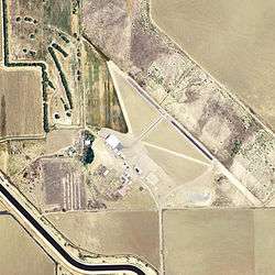
USGS 2006 orthophoto | |||||||||||
| IATA: none – ICAO: none – FAA LID: CL01 | |||||||||||
| Summary | |||||||||||
| Airport type | Private | ||||||||||
| Owner | Joseph L. Davis | ||||||||||
| Serves | Dos Palos, California | ||||||||||
| Elevation AMSL | 153 ft / 47 m | ||||||||||
| Coordinates | 36°53′59″N 120°40′04″W / 36.89972°N 120.66778°WCoordinates: 36°53′59″N 120°40′04″W / 36.89972°N 120.66778°W | ||||||||||
| Website | www.EagleField.net | ||||||||||
| Map | |||||||||||
 CL01 Location of airport in California | |||||||||||
| Runways | |||||||||||
| |||||||||||
| Statistics | |||||||||||
| |||||||||||
Eagle Field (FAA LID: CL01) is a privately owned, private use airport in Fresno County, California, United States.[1] It is located seven nautical miles (8 mi, 13 km) southwest of the central business district of Dos Palos,[1] a city in neighboring Merced County.[2]
History
It was first activated on June 24, 1943 as United States Army Air Forces primary (level 1) pilot training airfield known as Dos Palos Airport. It was assigned to the USAAF West Coast Training Center (later Western Flying Training Command), operated under contract by Coast Aviation Corp. The airport had three turf runways, aligned 00/18 (1,900 feet); 09/27 (1,900 feet), and 13/31 (2,300 feet). It had several satellite airfields in the local area for emergency and overflow landings.
- Hammond Auxiliary Field (location undetermined)
- Vail Auxiliary Field (36°46′12″N 120°40′00″W / 36.77000°N 120.66667°W)
- Dos Palos Emergency Field (36°50′35″N 120°43′00″W / 36.84306°N 120.71667°W)
- Canal Field Auxiliary Field (36°56′34″N 120°47′20″W / 36.94278°N 120.78889°W)
- Mason Auxiliary Field (36°43′50″N 120°34′50″W / 36.73056°N 120.58056°W)
Flying training was performed with Ryan PT-22s as the primary trainer. Also had several PT-17 Stearmans and a few P-40 Warhawks assigned. It was inactivated on December 28, 1944 with the drawdown of AAFTC's pilot training program and was declared surplus and turned over to the Army Corps of Engineers.
The base was then used as an aircraft storage depot for excess USAAF training aircraft, having UC-78s, PT-17s, Vultee BT-13/15, and AT-6 Texans. Eventually it was discharged to the War Assets Administration (WAA) and was used as a crop dusting airfield. After the war, the City of Dos Palos briefly operated a golf course on the site before the property reverted to the federal government. In 1980 it was put up for auction.
Eagle Field was in a short scene of the movie Indiana Jones and the Kingdom of the Crystal Skull.
Central California Historical Military Museum
Later on it became home of the Central California Historical Military Museum, which continues to operate at the field. The museum is also known as Eagle Field AAF - WWII Living History and Military Museum. Many wartime buildings remain at the airfield which is open to the public.
Facilities and aircraft
Eagle Field covers an area of 127 acres (51 ha) at an elevation of 153 feet (47 m) above mean sea level. It has one runway designated 12/30 with an asphalt surface measuring 2,300 by 60 feet (701 x 18 m). There are 8 aircraft based at this airport: 6 single-engine, 1 multi-engine, and 1 jet.[1]
See also
References
- 1 2 3 4 FAA Airport Master Record for CL01 (Form 5010 PDF). Federal Aviation Administration. Effective May 31, 2012.
- ↑ "Map showing locations of airport, city, and county borders". MapQuest. Retrieved July 26, 2012.
| Wikimedia Commons has media related to Dos Palos Airport. |
Other sources
-
 This article incorporates public domain material from the Air Force Historical Research Agency website http://www.afhra.af.mil/.
 - Shaw, Frederick J. (2004), Locating Air Force Base Sites History’s Legacy, Air Force History and Museums Program, United States Air Force, Washington DC, 2004.
- Manning, Thomas A. (2005), History of Air Education and Training Command, 1942–2002. Office of History and Research, Headquarters, AETC, Randolph AFB, Texas ASIN: B000NYX3PC
External links
- Eagle Field at Central California Historical Military Museum
- Aerial image as of August 1998 from USGS The National Map
- Resources for this airport:
- FAA airport information for CL01
- AirNav airport information for CL01
- FlightAware airport information and live flight tracker
- SkyVector aeronautical chart for CL01
| Flying Training |
|  | ||||||
|---|---|---|---|---|---|---|---|---|
| Technical Training |
| |||||||