East Dubuque, Illinois
| East Dubuque | |
| City | |
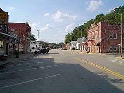 Downtown East Dubuque, along Sinsinawa Ave. | |
| Country | United States |
|---|---|
| State | Illinois |
| County | Jo Daviess |
| Township | Dunleith |
| Elevation | 610 ft (186 m) [1] |
| Coordinates | 42°29′28″N 90°38′28″W / 42.49111°N 90.64111°WCoordinates: 42°29′28″N 90°38′28″W / 42.49111°N 90.64111°W |
| Area | 2.89 sq mi (7 km2) |
| - land | 2.81 sq mi (7 km2) |
| - water | 0.08 sq mi (0 km2) |
| Population | 1,704 (2010) |
| Density | 967.4/sq mi (374/km2) |
| Timezone | CST (UTC-6) |
| - summer (DST) | CDT (UTC-5) |
| Postal code | 61025 |
| Area code | 815 |
| FIPS code | 17-21683 |
| GNIS ID(s) | 407631, 2394598 |
  Location of East Dubuque within Illinois | |
| Wikimedia Commons: East Dubuque, Illinois | |
| Website: www | |
East Dubuque is a city in Jo Daviess County, Illinois, United States. The population was 1,704 at the 2010 census, down from 1,995 in 2000. East Dubuque is located alongside the Mississippi River. Across the river is the city of Dubuque, Iowa. About three miles north of the city is the Illinois – Wisconsin border.
History
East Dubuque was originally called Dunleith, and under the latter name was platted in 1853.[2] The present name comes from the city's location east of Dubuque.[3] A post office was established at Dunleith in 1854, and the post office was renamed East Dubuque in 1879.[4]
Transportation
The main roads in East Dubuque are Sinsinawa Avenue and U.S. Route 20 (Wall Street). The Julien Dubuque Bridge serves as the connection between East Dubuque and Dubuque. Illinois Route 35 serves as the primary connection between East Dubuque and Wisconsin.
Geography
East Dubuque is located at 42°29′28″N 90°38′28″W / 42.49111°N 90.64111°W (42.491103, -90.641214).[5]
According to the 2010 census, East Dubuque has a total area of 2.891 square miles (7.49 km2), of which 2.81 square miles (7.28 km2) (or 97.2%) is land and 0.081 square miles (0.21 km2) (or 2.8%) is water.[6]
Demographics
| Historical population | |||
|---|---|---|---|
| Census | Pop. | %± | |
| 1880 | 1,037 | — | |
| 1890 | 1,069 | 3.1% | |
| 1900 | 1,146 | 7.2% | |
| 1910 | 1,253 | 9.3% | |
| 1920 | 1,163 | −7.2% | |
| 1930 | 1,395 | 19.9% | |
| 1940 | 1,475 | 5.7% | |
| 1950 | 1,697 | 15.1% | |
| 1960 | 2,082 | 22.7% | |
| 1970 | 2,408 | 15.7% | |
| 1980 | 2,194 | −8.9% | |
| 1990 | 1,914 | −12.8% | |
| 2000 | 1,995 | 4.2% | |
| 2010 | 1,704 | −14.6% | |
| Est. 2015 | 1,658 | [7] | −2.7% |
As of the census[9] of 2000, there were 1,995 people, 864 households, and 527 families residing in the city. The population density was 967.4 people per square mile (373.9/km²). There were 932 housing units at an average density of 451.9 per square mile (174.7/km²). The racial makeup of the city was 99.10% White, 0.15% African American, 0.05% Native American, 0.20% Asian, 0.20% from other races, and 0.30% from two or more races. Hispanic or Latino of any race were 1.05% of the population.
There were 864 households out of which 27.9% had children under the age of 18 living with them, 48.1% were married couples living together, 8.1% had a female householder with no husband present, and 38.9% were non-families. 34.0% of all households were made up of individuals and 13.4% had someone living alone who was 65 years of age or older. The average household size was 2.31 and the average family size was 2.97.
In the city the population was spread out with 23.3% under the age of 18, 8.8% from 18 to 24, 28.4% from 25 to 44, 23.5% from 45 to 64, and 16.0% who were 65 years of age or older. The median age was 38 years. For every 100 females there were 105.9 males. For every 100 females age 18 and over, there were 99.2 males.
The median income for a household in the city was $35,099, and the median income for a family was $45,924. Males had a median income of $31,010 versus $19,459 for females. The per capita income for the city was $20,984. About 2.1% of families and 4.3% of the population were below the poverty line, including 3.3% of those under age 18 and 6.9% of those age 65 or over.
Notable person
- Arthur Joseph O'Neill, Roman Catholic bishop
Prominent landmarks
References
- ↑ "Newtown". Geographic Names Information System. United States Geological Survey. Retrieved 2007-10-21.
- ↑ Klinkenberg, Dean (1 January 2009). Travel Guide Lansing, Iowa to LeClaire : Along the Mississippi River in Iowa, Illinois, and Wisconsin. Dean Klinkenberg. p. 250. ISBN 978-0-9716904-4-8.
- ↑ Callary, Edward (29 September 2008). Place Names of Illinois. University of Illinois Press. p. 103. ISBN 978-0-252-09070-7.
- ↑ "Jo Daviess County". Jim Forte Postal History. Retrieved 4 November 2015.
- ↑ "US Gazetteer files: 2010, 2000, and 1990". United States Census Bureau. 2011-02-12. Retrieved 2011-04-23.
- ↑ "G001 - Geographic Identifiers - 2010 Census Summary File 1". United States Census Bureau. Retrieved 2015-12-27.
- ↑ "Annual Estimates of the Resident Population for Incorporated Places: April 1, 2010 to July 1, 2015". Retrieved July 2, 2016.
- ↑ "Census of Population and Housing". Census.gov. Retrieved June 4, 2015.
- ↑ "American FactFinder". United States Census Bureau. Retrieved 2008-01-31.
External links
Municipalities and communities of Jo Daviess County, Illinois, United States | ||
|---|---|---|
| Cities | ||
| Villages | ||
| Townships | ||
| CDPs | ||
| Other unincorporated communities | ||
| Ghost town | ||