East Island / Whangaokeno
| Whangaokeno (Māori) | |
|---|---|
 View of East Island from East Cape. | |
| Geography | |
| Location | Gisborne Region |
| Coordinates | 37°41′28.65″S 178°34′33.10″E / 37.6912917°S 178.5758611°E |
| Area | 13 ha (32 acres) |
| Highest elevation | 129 m (423 ft) |
| Administration | |
| Demographics | |
| Population | 0 |
East Island / Whangaokeno[1] is a small (13-hectare or 32-acre)[2] island approximately 2 km (1.2 mi) east of East Cape in the North Island of New Zealand. Reaching an elevation of 129 m (423 ft),[2] it was the original location for the East Cape Lighthouse, which was built in 1900. However, the island is prone to earthquakes and its steep cliffs cause numerous landslides. By 1920, the danger to the lighthouse was considered great enough to trigger a decision to move the lighthouse to the mainland. In 1922, the lighthouse was extinguished and relocated to its current position.
Coordinates: 37°41′28.65″S 178°34′33.10″E / 37.6912917°S 178.5758611°E
-
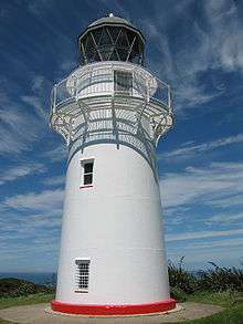
East Island was the original location of the East Cape Lighthouse.
-
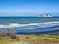
East Island seen from the bottom of the Otiki Hill
See also
References
- ↑ Also known as Motu o Kaiawa, see Kate MacIntyre, Te Whanau a Apanui and the East Coast Inquiry District, Waitangi Tribunal Scoping Report, Wai 900 #A9, p. 37.
- 1 2 East Island / Whangaokeno, Rodent Invasion Project, Department of Statistics, University of Auckland. Retrieved 1 December 2009.