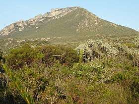
East Mount Barren
| East Mount Barren | |
|---|---|
 | |
| Highest point | |
| Elevation | 311 m (1,020 ft) |
| Coordinates | 33°55′23″S 120°1′30″E / 33.92306°S 120.02500°E |
| Geography | |
| Location | Goldfields-Esperance region of Western Australia |
| Parent range | Barren Range |
East Mount Barren is one of three quartzite peaks of the Barren Range in Fitzgerald River National Park.[1] The three peaks, West Mount Barren, Middle and East Mount Barren, were named by explorer Matthew Flinders on 6 January 1802.[2] All were named because of their barren appearance.[3] A walking track ascends 200 metres (656 ft) in height to the summit which has views of the coast from the Doubtful Islands to Mason Point as well as 50 kilometres (31 mi) inland.[1]
Plant species that are endemic to East Barren Mountain and its immediate environs include Calothamnus macrocarpus, Eucalyptus burdettiana (Burdett Gum), Kunzea similis subsp. similis, Regelia velutina (Barrens regelia) and Verticordia pityrhops. Other species of note include Acacia argutifolia (East Barrens Wattle), Adenanthos ellipticus (Oval-leaf Adenanthos), Anthocercis fasciculata, Banksia speciosa (Showy Banksia), Dampiera deltoidea, Eucalyptus coronata (Crowned Mallee), Gonocarpus hispidus, Hakea hookerana, Hibbertia papillata, Jacksonia compressa, Leptospermum confertum, Leucopogon compactus, Melaleuca papillosa, Pimelea physodes (Qualup Bell) and Stylidium galioides (Yellow Mountain Triggerplant).[4]
-
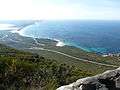
View east from summit
-
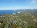
View west from summit
References
- 1 2 "East Mount Barren Walk". Fitzgerald Coast Visitor Centre. Retrieved 18 February 2013.
- ↑ Matthew Flinders (1814). A voyage to Terra Australis: undertaken for the purpose of completing the discovery of that vast country, and prosecuted in the years 1801, 1802 and 1803. G. & W. Nicol. pp. 76–. Retrieved 18 February 2013.
- ↑ "Western Australian names". Sunday Times. Perth, Western Australia: National Library of Australia. 5 February 1928. p. 18. Retrieved 5 December 2013.
- ↑ Craig, Gillian F. (July 2010). "Vegetation and Flora" (PDF). Fitzgerald River National Park Improvement Project: Culham Inlet to Hamersley Inlet. Main Roads Western Australia. Retrieved 18 February 2013.