Edithburgh
| Edithburgh South Australia | |||||||||||||
|---|---|---|---|---|---|---|---|---|---|---|---|---|---|
 Edith Street | |||||||||||||
 Edithburgh | |||||||||||||
| Coordinates | 35°05′0″S 137°44′0″E / 35.08333°S 137.73333°ECoordinates: 35°05′0″S 137°44′0″E / 35.08333°S 137.73333°E | ||||||||||||
| Population | 466 (2011 census)[1] | ||||||||||||
| Established | 1869 | ||||||||||||
| Postcode(s) | 5583 | ||||||||||||
| Location | |||||||||||||
| LGA(s) | Yorke Peninsula Council | ||||||||||||
| State electorate(s) | Goyder[2] | ||||||||||||
| Federal Division(s) | Grey[3] | ||||||||||||
| |||||||||||||
| Footnotes | Adjoining localities[4][5] | ||||||||||||

Edithburgh /ˈiːdᵻθbɜːrɡ/ is a small town on the south-east corner of Yorke Peninsula in the Australian state of South Australia. Edithburgh is about 50 km (31 mi) west of Adelaide across Gulf St Vincent, but 226 km (140 mi) away by road. At the 2011 census, the town had a population of 466.[1]
Edithburgh is in the Yorke Peninsula Council, the South Australian House of Assembly electoral district of Goyder and the Australian House of Representatives Division of Grey.
History
In the Narangga language of the indigenous Narungga people, Edithburgh was known by the place name Pararmarati.[6] Some sources give the pronunciation 'Barram-marrat-tee'. The first European pioneers arrived in the 1840s and were sheep graziers and pastoralists. With closer settlement, in 1869 the Marine Board fixed a site for a jetty to service the developing farming district. An adjacent town was then surveyed, the layout closely emulating (on a smaller scale) that of Adelaide, with a belt of parklands. Edithburgh was named by Governor Sir James Fergusson after his wife Edith. The new jetty opened in 1873.[7]
Industries
Edithburgh originally developed as a port for servicing the pastoralist pioneers. In the 1870s grain farming became a mainstay of the local economy, which it still is. At the turn of the 20th Century additional industries were established in the form of gypsum mining and salt refining. There are vast salt lakes in the area, from which salt was scraped and exported as far as Russia. Among those refineries was the Standard Salt Company, operated by C.T. McGlew. The jetty became a busy hub for exporting these commodities, as well as unloading supplies.
Nowadays the jetty is used mostly for recreational fishing and is a popular scuba diving site. There is also a small fishing and prawning fleet based there. The town is now overshadowed by the 55 wind turbines of the Wattle Point Wind Farm, located southwest of the town and opened in April 2005.
Tourism
Occupying a commanding position on the coastline at semi-circular Salt Creek Bay, Edithburgh is noted for its magnificent seascapes which include steep rocky cliffs and sandy beaches. Troubridge Island can be seen offshore. As a result, tourism is now a growth industry. It is a popular holiday destination with a variety of accommodation types available including a caravan park. The Troubridge Hotel and the Edithburgh Hotel sit diagonally opposite each other at the intersection of Blanche and Edith Streets, both named after Governor Fergusson's daughters.
For those who prefer not to swim in the open sea, the town has a unique seawater swimming pool constructed at the shoreline. Its sheltered waters are refreshed with each rising tide.[8]
Diving and snorkeling

Many divers, scientists and marine conservationists list Edithburgh jetty as one of South Australia's premier shore-dive locations. Access is easy thanks to steps on northern and southern sides of the structure.[9]
The jetty extends eastwards into Gulf St. Vincent and is 170 m in length. The jetty is supported by pylons in groups of four.[9] Divers and snorkelers can safely and closely observe dense, multi-coloured colonies of temperate corals and sponges on the jetty pylons. The pylons also provide refuges for various fish, crustacea, nudibranchs and other marine invertebrates.
Several of the state's iconic marine species can be seen beneath or near the jetty, including the Leafy sea dragon and the Striped pyjama squid.[10][11]
The maximum dive depth is 10–12 m and site is rewarding for visitors of all experience levels.[12]
Jetty maintenance and habitat loss

In December 2013, maintenance works were conducted at the Edithburgh jetty by a contractor working for the local council. An estimated 50 jetty pylons were removed from the periphery of the jetty. They were either sawed off at the seabed, or pulled up from the substrate. This resulted in an immediate loss of habitat and marine life, upsetting many members of the scuba diving and marine conservation community.[13][14]
Jetty pylons had been assessed some years prior by the State Government's Department of Transport, Energy and Infrastructure (now known as the Department of Planning, Transport and Infrastructure) and identified as a public liability risk. Impacts to the marine environment or the site's iconic status as a dive tourism hotspot do not appear to have been considered by DPTI or the local council.
Recreational divers from M.E. Dive Club witnessed the early works and arranged a group of divers to informally assess the damage the following weekend. The pylon removal works were not publicly advertised nor was the dive or tourism community consulted on the works. The Scuba Divers Federation of South Australia and the Marine Life Society of South Australia both responded to the issue by drafting letters to responsible Government bodies.[15]
Gallery
 Seahorse beneath Edithburgh Jetty
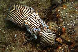 Striped Pyjama squid mating under Edithburgh jetty
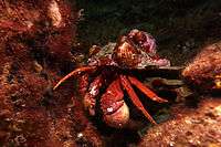 Hermit crab beneath Edithburgh jetty
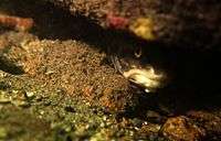 Rock ling beneath Edithburgh jetty
See also
References
- 1 2 Australian Bureau of Statistics (31 October 2012). "Edithburgh (state suburb)". 2011 Census QuickStats. Retrieved 22 February 2016.
- ↑ "Goyder electorate boundaries as of 2014". ELECTORAL COMMISSION SA. Retrieved 23 July 2015.
- ↑ "Federal electoral division of Grey" (PDF). Australian Electoral Commission. Retrieved 24 July 2015.
- ↑ "New Ward Structure 2014". Yorke Peninsula Council. Retrieved 21 October 2015.
- ↑ "GEOGRAPHICAL NAMES ACT 1991 Notice to Alter the Names and Boundaries of Places" (PDF). The South Australian Government Gazette. 10 November 2011. p. 4444. Retrieved 2 November 2015.
- ↑ Tindale, Norman B., 1936. Notes on the Natives of Southern portion of Yorke Peninsula, S.A.. Proc. of Royal Soc. of Aust., vol 60., pp 55-70.
- ↑ Collins, Neville: The Jetties of South Australia, (Adelaide 2010) ISBN 978 0 9580482 4 8
- ↑ "Edithburgh" Country Getaways (accessed 2013-12-14)
- 1 2 "Edithburgh" BenAndCamera.com
- ↑ "Diving Edithburgh Jetty" Underwater Photography Guide
- ↑ Williamson, Brett "Underwater treasures: Edithburgh jetty" 891 ABC Adelaide, January 14, 2013. Accessed 2013-12-13.
- ↑ "Edithburgh Jetty" SouthAustralia.com
- ↑ "Pylons removal next to Edithburgh jetty angers marine and dive groups on Yorke Peninsula" ABC News 2013-12-17.
- ↑ Robertson, Kim "Dive anger over jetty work" ABC News 2013-11-17.
- ↑ Oldland, Jenny "Pylon removals impact marine life" Yorke Peninsula Country Times (2013-12-17). Retrieved 2014-01-03.
External links
| Wikimedia Commons has media related to Edithburgh, South Australia. |
 Edithburgh travel guide from Wikivoyage
- Edithburgh Jetty travel guide from Wikivoyage
- Yorke Peninsula: Edithburgh
| Major Townships | |||||||||||
|---|---|---|---|---|---|---|---|---|---|---|---|
| Minor Townships | |||||||||||
| Governance |
| ||||||||||
| Coastal features | |||||||||||
| Protected areas |
| ||||||||||
| Islands adjoining the Yorke Peninsula coast | |||||||||||
| Related and uncategorised | |||||||||||
| |||||||||||