Edleston
| Edleston | |
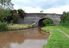 Marsh Lane Bridge over the Shropshire Union Canal |
|
 Edleston |
|
| Population | 53 (2001) |
|---|---|
| OS grid reference | SJ636507 |
| Civil parish | Edleston |
| Unitary authority | Cheshire East |
| Ceremonial county | Cheshire |
| Region | North West |
| Country | England |
| Sovereign state | United Kingdom |
| Post town | NANTWICH |
| Postcode district | CW5 |
| Dialling code | 01270 |
| Police | Cheshire |
| Fire | Cheshire |
| Ambulance | North West |
| EU Parliament | North West England |
| UK Parliament | Eddisbury |
Coordinates: 53°03′11″N 2°32′31″W / 53.053°N 2.542°W
Edleston is a civil parish in the unitary authority of Cheshire East and the ceremonial county of Cheshire, England, which lies immediately to the south west of Nantwich. For administrative purposes, it is combined with adjacent civil parishes of Acton and Henhull to form a total area of 765 hectares (1890 acres).[1] The parish is predominantly rural with scattered farms and houses, with the exception of a new housing estate at the eastern end of the parish east of the canal. Nearby villages include Acton and Ravensmoor.
According to the 2001 census, the parish had a population of 53.[2]
History
The Nantwich and Market Drayton Railway, constructed in 1863, ran southwards towards Audlem at the east of the parish; it is now dismantled.[1][3]
The parish of Edleston formerly had population figures of 88 (1801), 99 (1851), 74 (1901) and 58 (1951).[4]
Geography and transport
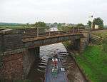
The Shropshire Union Canal runs north–south through the parish and the River Weaver runs along its eastern boundary. Edleston Brook runs east–west across the parish. The Welsh Marches Railway runs from the north east to the south west, crossing the canal immediately adjacent to Edleston Bridge.
Marsh Lane runs along the northern boundary of the parish; it crosses the Shropshire Union Canal at the grade-II-listed Marsh Lane Bridge, which dates from 1826 and was designed by Thomas Telford.[5] The A530 lies immediately to the south. The Crewe and Nantwich Circular Walk runs through the parish.
Notable features
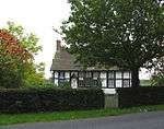
A ring-shaped mound, the remains of a moated site and fishpond, is located to the west of the Shropshire Union Canal by Edleston Bridge at SJ63795076; it is a Scheduled Ancient Monument.[6] Broomfield Cottage, Newbury Cottage, Edleston Farm House and Moss Cottage are grade-II-listed buildings on Marsh Lane.[7][8][9]
See also
References
- 1 2 Acton, Edleston and Henhull Parish Plan (accessed 17 August 2007)
- ↑ Combining Cheshire County Council: Local Statistics: Baddington - Edleston & Neighbourhood Statistics: Baddington CP (accessed 17 August 2007)
- ↑ The Village of Audlem: Village History (accessed 16 August 2007)
- ↑ Genuki: Edleston (accessed 17 August 2007)
- ↑ Images of England: Marsh Lane Bridge No.91 (accessed 24 February 2008)
- ↑ Borough of Crewe and Nantwich: Scheduled Ancient Monuments (accessed 17 August 2007)
- ↑ Images of England: Broomfield Cottage and Newbury Cottage (accessed 24 February 2008)
- ↑ Images of England: Edleston Farm House (accessed 24 February 2008)
- ↑ Images of England: Moss Cottage (accessed 24 February 2008)
External links
![]() Media related to Edleston at Wikimedia Commons
Media related to Edleston at Wikimedia Commons
Cheshire Portal | |
| Unitary authorities | |
| Major settlements | |
| Rivers | |
| Topics | |