El Reno Regional Airport
| El Reno Regional Airport Mustang Army Airfield | |||||||||||||||
|---|---|---|---|---|---|---|---|---|---|---|---|---|---|---|---|
|
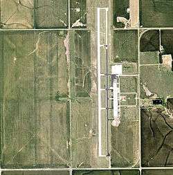
2006 USGS Orthophoto | |||||||||||||||
| IATA: none – ICAO: KRQO – FAA LID: RQO | |||||||||||||||
| Summary | |||||||||||||||
| Airport type | Public | ||||||||||||||
| Owner | City of El Reno | ||||||||||||||
| Serves | El Reno, Oklahoma | ||||||||||||||
| Elevation AMSL | 1,420 ft / 433 m | ||||||||||||||
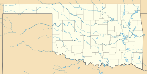
| Coordinates | 35°28′22″N 098°00′21″W / 35.47278°N 98.00583°W | ||||||||||||||
| Map | |||||||||||||||
 KRQO Location | |||||||||||||||
| Runways | |||||||||||||||
| |||||||||||||||
| Statistics (2008) | |||||||||||||||
| |||||||||||||||
El Reno Regional Airport (ICAO: KRQO, FAA LID: RQO) is in Canadian County, Oklahoma, five miles southwest of El Reno, which owns it.[1] The FAA's National Plan of Integrated Airport Systems for 2009–2013 categorized it as a general aviation facility.[2]
Many U.S. airports use the same three-letter location identifier for the FAA and IATA, but this facility is RQO to the FAA and has no IATA code.
History
The airport opened in 1943 as a United States Army Air Forces World War II primary (stage 1) pilot training airfield by the Army Air Forces Training Command Gulf Coast Training Center (later Central Flying Training Command). It was known as El Reno Field or Mustang Field.
It was operated by the 320th Flying Training detachment, with the Midwest Air School as a contract flying training provider. The Oklahoma Air College, Inc. also was a contractor to the USAAF at El Reno. Fairchild PT-19s were the primary trainer. Also had several PT-17 Stearmans and a few P-40 Warhawks assigned.
During wartime, the airfield had three turf runways, their alignment now unknown. It had several (between 3 and 6) local auxiliary landing fields for emergency or overflow landings. Known auxiliaries were at Calumet and Union City with several others in the El Reno area.
Pilot training at the airfield apparently ended during the summer of 1944, with the reduced demand for new pilots. The airfield was turned over to the local government at the end of the war. [3][4]
TWISTEX storm chasers Tim Samaras, his son Paul and colleague Carl Young of South Lake Tahoe, California lost their lives in an EF3 multiple-vortex tornado near this area on May 31, 2013.
Facilities
The airport covers 698 acres (282 ha) an elevation of 1,420 feet (433 m). It has two runways: 17/35 is 5,600 by 75 feet (1,707 x 23 m) concrete and 18/36 is 4,630 by 190 feet (1,411 x 58 m) turf.[1]
In the year ending February 12, 2008 the airport had 24,825 aircraft operations, average 68 per day: 99.9% general aviation and 0.1% military. 24 aircraft were then based at thie airport: 79% single-engine and 21% multi-engine.[1]
See also
References
- 1 2 3 4 FAA Airport Master Record for RQO (Form 5010 PDF). Federal Aviation Administration. Effective 3 June 2010.
- ↑ National Plan of Integrated Airport Systems for 2009–2013: Appendix A: Part 4 (PDF, 1.61 MB). Federal Aviation Administration. Updated 15 October 2008.
- ↑
 This article incorporates public domain material from the Air Force Historical Research Agency website http://www.afhra.af.mil/.
 - ↑ Shaw, Frederick J. (2004), Locating Air Force Base Sites History’s Legacy, Air Force History and Museums Program, United States Air Force, Washington DC, 2004.
| Wikimedia Commons has media related to Mustang Field. |
External links
- FAA Terminal Procedures for RQO, effective November 10, 2016
- Resources for this airport:
- FAA airport information for RQO
- AirNav airport information for KRQO
- FlightAware airport information and live flight tracker
- NOAA/NWS latest weather observations
- SkyVector aeronautical chart, Terminal Procedures
| Flying Training |
|  | ||||||
|---|---|---|---|---|---|---|---|---|
| Technical Training |
| |||||||