Elatochori
| Elatochori Ελατοχώρι | |
|---|---|
|
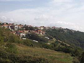
A view of Elatochori | |
 Elatochori | |
| Coordinates: 40°19.2′N 22°16′E / 40.3200°N 22.267°ECoordinates: 40°19.2′N 22°16′E / 40.3200°N 22.267°E | |
| Country | Greece |
| Administrative region | Central Macedonia |
| Regional unit | Pieria |
| Municipality | Katerini |
| Municipal unit | Pierioi |
| Highest elevation | 780 m (2,560 ft) |
| Lowest elevation | 760 m (2,490 ft) |
| Community[1] | |
| • Population | 533 (2011) |
| • Area (km2) | 38.872 |
| Time zone | EET (UTC+2) |
| • Summer (DST) | EEST (UTC+3) |
| Postal code | 601 00 |
| Area code(s) | +30-2351-xxx-xxx |
| Vehicle registration | KNx-xxxx |
Elatochori (Greek: Ελατοχώρι) is a village and a community of the Katerini municipality.[2] Before the 2011 local government reform it was part of the municipality of Pierioi, of which it was a municipal district.[2] The 2011 census recorded 533 inhabitants in the village.[1] The community of Elatochori covers an area of 38.872 km2.[3]
Geography
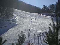
Elatochori ski centre.
Elatochori is situated west of Katerini, and south of Veria. It is a mountainous village that lies on the Pierian Mountains. There is also a ski resort 6 km from the village.
Population
According to the 2011 census, the population of Elatochori was 533 people, a decrease of almost 13% compared to the previous census of 2001.[1][3]
|
See also
References
- 1 2 3 4 "Απογραφή Πληθυσμού - Κατοικιών 2011. ΜΟΝΙΜΟΣ Πληθυσμός" (in Greek). Hellenic Statistical Authority.
- 1 2 Kallikratis law Greece Ministry of Interior (Greek)
- 1 2 3 "Population & housing census 2001 (incl. area and average elevation)" (PDF) (in Greek). National Statistical Service of Greece.
This article is issued from Wikipedia - version of the 11/2/2016. The text is available under the Creative Commons Attribution/Share Alike but additional terms may apply for the media files.