Electoral district of Loddon (Victorian Legislative Council)
For the lower house seat in the Victorian Legislative Assembly 1856–1859, see Electoral district of Loddon.
| District of Loddon Victoria—Legislative Council | |
|---|---|
|
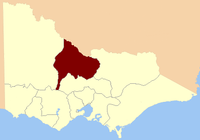
Location in Victoria | |
| State | Victoria |
| Created | 1851 |
| Abolished | 1856 |
| Demographic | Rural |
The Electoral district of Loddon was one of the original sixteen electoral districts[1] of the old unicameral Victorian Legislative Council of 1851 to 1856. Victoria being a colony in Australia at the time. Coordinates: 36°S 144°E / 36°S 144°E
The Electoral district of Loddon's area was defined as: "Bounded on the south by the Counties of Dalhousie Talbot and Ripon from the Goulburn River to the source of the Avoca River on the west by the Avoca River to Lake Bael Bael and thence by a line due north to the River Murray on the north and north-east by the River Murray and the Goulburn River and on the east by the Goulburn River."[1]
Members
One member originally, two from the expansion of the Council in 1853.[2]
| Member 1 | Term | ||
|---|---|---|---|
| William Campbell | Nov. 1851 – May 1854[r] | Member 2 | Term |
| Thomas Howard Fellows | Sep. 1854 – Mar. 1856 | John Goodman | Aug. 1853 – Mar. 1856 |
r = resigned
References
- 1 2 "Victorian Electoral Act" (PDF). New South Wales Government. Retrieved 17 May 2013.
- ↑ Sweetman, Edward (1920). Constitutional Development of Victoria, 1851-6. Whitcombe & Tombs Limited. p. 108. Retrieved 17 May 2013.
- "Re-Member (Former Members)". State Government of Victoria. Retrieved 17 May 2013.
This article is issued from Wikipedia - version of the 9/20/2016. The text is available under the Creative Commons Attribution/Share Alike but additional terms may apply for the media files.