Elm-Maple-South Streets Historic District
|
Elm-Maple-South Streets Historic District | |
|
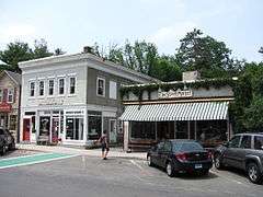
Mercantile Building | |
  | |
| Location | Stockbridge, Massachusetts |
|---|---|
| Coordinates | 42°16′46″N 73°18′47″W / 42.27944°N 73.31306°WCoordinates: 42°16′46″N 73°18′47″W / 42.27944°N 73.31306°W |
| Built | 1860 |
| Architect | Franz, Joseph; et al. |
| Architectural style | Federal, Greek Revival |
| NRHP Reference # | [1] |
| Added to NRHP | September 8, 2004 |
The Elm-Maple-South Streets Historic District is a historic district encompassing part of the historic downtown of Stockbridge, Massachusetts. The most prominent parts of Stockbridge lie within the Main Street Historic District, which abuts this district to the north. The southern boundary of this district is the railroad tracks that run parallel to the Housatonic River. The eastern boundary of the district is Laurel Hill, a wooded park overlooking the town, and the western boundary is a terraced shelf in the plains of the river. The district includes properties on Depot, Elm, Maple, and South Streets, and Laurel Lane. Unlike Main Street, this district consists of more densely place residences, and narrower roads containing businesses just off Main Street. Its buildings were mostly constructed during the late 19th and early 20th centuries, and partially reflect Elm Street's function as an industrial part of the town.[2]
The district was added to the National Register of Historic Places in 2004.[1]
See also
- National Register of Historic Places listings in Berkshire County, Massachusetts
- Norman Rockwell, whose studio was originally at 8 South Street
References
- 1 2 National Park Service (2008-04-15). "National Register Information System". National Register of Historic Places. National Park Service.
- ↑ "NRHP nomination form for Elm-Maple-South Streets Historic District". Commonwealth of Massachusetts. Retrieved 2013-12-02.
| Topics |  | ||||||||||||||||||||||||||||||
|---|---|---|---|---|---|---|---|---|---|---|---|---|---|---|---|---|---|---|---|---|---|---|---|---|---|---|---|---|---|---|---|
| Lists by county | |||||||||||||||||||||||||||||||
| Lists by city |
| ||||||||||||||||||||||||||||||
| Other lists | |||||||||||||||||||||||||||||||
| |||||||||||||||||||||||||||||||