Elumalai
| Elumalai Singh | |
|---|---|
| city | |
 Elumalai Location in Tamil Nadu, India | |
| Coordinates: 9°52′N 77°42′E / 9.87°N 77.7°ECoordinates: 9°52′N 77°42′E / 9.87°N 77.7°E | |
| Country |
|
| State | Tamil Nadu |
| District | Madurai |
| Area | |
| • Total | 8.04 km2 (3.10 sq mi) |
| Elevation | 208 m (682 ft) |
| Population (2011) | |
| • Total | 15,746 |
| • Density | 2,000/km2 (5,100/sq mi) |
| Languages | |
| • Official | Tamil |
| Time zone | IST (UTC+5:30) |
Elumalai (எழுமலை) is a Panchayat town in the district of Madurai, Tamil Nadu, India. Originally named Aezhumalai (meaning Seven Hills), the town is located near Usilampatti (16 km) and Peraiyur, in the Western ghats. It has a number of religious sites, including the Vasi Malayan, Shri Thiruvenkatanatha Swami, Muthalamman, Badrakali Amman, Sandana Mariyamman and Maathanthira Shri Subramania temples, as well as a mosque and church.
Education
According to a 2011 census, 58% of the total population is literate, which is lower than the state's literacy rate of 59.5%. The government runs a boys and girls school and there is also a private high school. The Bharathiyar Matric Higher is a Secondary School, which provides secondary education. In addition, there are many primary schools in town and the surrounding villages.
Geography
Elumalai is located at 9°52′N 77°42′E / 9.87°N 77.7°E.[1] It has an average elevation of 208 metres (682 feet).
Demographics
According to the 2011 census, the Elumalai Town Panchayat has a population of 15,746, of which 7,890 are male and 7,856 are female. The number of children aged up to six is 1,725, which amounts to 10.96% of the total population.
As of the 2001 India census,[2] Elumalai had a population of 14,030. Males constitute 50% of the population and females 50%. 10% of the population are under 6 years of age. Elumalai has an average literacy rate of 56%, which is lower than the national average of 59.5%. Male literacy is 67% and female literacy is 45%.
Nature
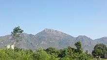
The town is surrounded by seven hills and is famous for the Sathuragiri Hill close to Saptur. The seven hills provide an abundant variety of flora. In addition, the Elumalai Vasimalayan mountain serves as a boundary between the Madurai and Theni districts. Every year, the month of September sees the celebration of the Vasimalayan festival. Also, every Saturday, free food is provided by the Vasimalayan Temple.
Airports
- Madurai Airport (43 km)
- Tuticorin Airport (130 km)
- Cochin Intl Airport (150 km)
- Coimbatore Airport (150 km)
- Tiruchirappalli Airport (150 km)
References
- ↑ Falling Rain Genomics, Inc - Elumalai
- ↑ "Census of India 2001: Data from the 2001 Census, including cities, villages and towns (Provisional)". Census Commission of India. Archived from the original on 2004-06-16. Retrieved 2008-11-01.