Erdre
| Erdre | |
|---|---|
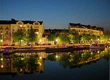 The quai de Versailles in Nantes | |
| Native name | L'Edre (f) |
| Country | France |
| Basin | |
| Main source | Maine-et-Loire |
| River mouth |
Loire 47°12′42″N 1°32′22″W / 47.21167°N 1.53944°WCoordinates: 47°12′42″N 1°32′22″W / 47.21167°N 1.53944°W |
| Progression | Loire→ Atlantic Ocean |
| Basin size | 936 km2 (361 sq mi) |
| Physical characteristics | |
| Length | 97 km (60 mi) |
| Discharge |
|
The Erdre is a river in western France, right tributary to the Loire. Its source is in the Maine-et-Loire département, near La Pouëze. It flows through the départements Maine-et-Loire and Loire-Atlantique. It flows into the Loire in the city Nantes. Other towns on the Erdre, going downstream, are Candé, Riaillé, Nort-sur-Erdre and Sucé-sur-Erdre.
The Erdre is unusual in that it widens out as one travels up-river. At its lowest point, where it joins the Loire in Nantes, its former course is now a main road and shopping area, the Cours des Cinquante Otages. The Erdre now has to reach the Loire via the St Felix canal tunnel under Rue Henri IV, emerging near the main railway station.
However travel some 15 kilometres up stream and the Erdre has widened from a few hundred metres to nearly a kilometre wide, at the Plaine des Mazeroles, near Sucré sur Erdre. Broad marshlands partially reclaimed make the river even wider. Above here, the Nantes-Brest canal goes off to the west, and we have another small town, Nort-sur-Erdre. Above here, the Erdre has many small streams crossing the low hills of this part of north west France. There are pretty villages but don't come here looking for spectacular scenery. Good walking country, especially if you like to follow the many disused railways, mainly abandoned complete with rusting rail lines, a relic to France's very own Beeching cuts.
References
-
 Media related to Erdre at Wikimedia Commons
 - geoportail.fr
- The Erdre at the Sandre database