Escaldes-Engordany
| Escaldes-Engordany | ||
|---|---|---|
| ||
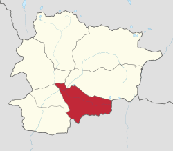 Escaldes-Engordany Location of Escaldes-Engordany within Andorra | ||
| Coordinates (Escaldes town): 42°30′32″N 1°32′27″E / 42.50889°N 1.54083°ECoordinates: 42°30′32″N 1°32′27″E / 42.50889°N 1.54083°E | ||
| Country | Andorra | |
| Parishes | Escaldes-Engordany | |
| Villages | Escaldes, Engordany, El Fener, Els Vilars d'Engordany, Engolasters | |
| Government | ||
| • Mayor | Montserrat Capdevila Pallarés | |
| Area | ||
| • Total | 30 km2 (10 sq mi) | |
| Elevation | 1,050 m (3,440 ft) | |
| Population (2005) | ||
| • Total | 14,395 | |
| • Density | 479.83/km2 (1,242.8/sq mi) | |
| Demonym(s) | escaldenc, escaldenca | |
| Website | Official site | |

Escaldes-Engordany (Catalan pronunciation: [əsˈkaɫdəz əŋɡurˈðaɲ], locally: [asˈkaɫdez aŋɡoɾˈðaɲ]) is one of the parishes of Andorra. The parish is composed of the areas of les Escaldes, Engordany, Els Vilars d'Engordany, Engolasters, and El Fener. As of 2014 it has a population of 13,634. Notable events include the town's annual jazz festival.
Education
The Spanish international primary school Escuela Española de Escaldes serves the community.[1]
References
External links
![]() Media related to Escaldes-Engordany at Wikimedia Commons
Media related to Escaldes-Engordany at Wikimedia Commons
 |
|
|
|
|
| |
|
Cerdanya, Spain | ||
| ||||
| | ||||
| |
|
Cerdanya, Spain |
This article is issued from Wikipedia - version of the 11/20/2016. The text is available under the Creative Commons Attribution/Share Alike but additional terms may apply for the media files.