Essex County Airport
| Essex County Airport | |||||||||||||||
|---|---|---|---|---|---|---|---|---|---|---|---|---|---|---|---|
 | |||||||||||||||
| IATA: CDW – ICAO: KCDW – FAA LID: CDW | |||||||||||||||
| Summary | |||||||||||||||
| Airport type | Public | ||||||||||||||
| Owner | Essex County Improvement Authority | ||||||||||||||
| Serves | Caldwell, New Jersey | ||||||||||||||
| Elevation AMSL | 172 ft / 52 m | ||||||||||||||
| Coordinates | 40°52′31″N 074°16′53″W / 40.87528°N 74.28139°WCoordinates: 40°52′31″N 074°16′53″W / 40.87528°N 74.28139°W | ||||||||||||||
| Website |
www | ||||||||||||||
| Map | |||||||||||||||
 CDW Location in Essex County, New Jersey | |||||||||||||||
| Runways | |||||||||||||||
| |||||||||||||||
| Statistics (2012) | |||||||||||||||
| |||||||||||||||
Essex County Airport (IATA: CDW[2], ICAO: KCDW, FAA LID: CDW), informally "Caldwell Airport",[3] is a public use airport located in Fairfield Township, Essex County, New Jersey, two nautical miles (4 km) north of the central business district of Caldwell, a borough of northwestern Essex County in the U.S. state of New Jersey. It is owned by the Essex County Improvement Authority.[1] This facility is included in the National Plan of Integrated Airport Systems for 2011–2015, which categorized it as a general aviation reliever airport.[4]
History
In April 1929 Essex Airport Corporation was formed by Walter Marvin and six other individuals. The intention of the company was to open an airport to serve Montclair, New Jersey, a town seven miles (11 km) away. The tract of land that Essex Airport Corporation intended for the airport was the Fairfield Dairy Company land that had also been used during World War I as a temporary airfield for the Naval Rifle Range which had been located along the Passaic River in Pine Brook. Some of the early references to airport have the designation “Marvin Airport”, named after Walter Marvin.[5]
The airport gained national attention when John F. Kennedy, Jr., who based his private aircraft there, crashed hours after departing the airport en route for Martha's Vineyard Airport with his wife and sister-in-law on July 16, 1999.[5]
Facilities and aircraft
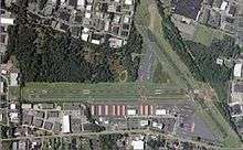
_Dec_2015.jpeg)
Essex County Airport covers an area of 275 acres (111 ha) at an elevation of 172 feet (52 m) above mean sea level. It has two runways with asphalt surfaces: 4/22 is 4,552 by 80 feet (1,387 x 24 m) and 10/28 is 3,719 by 75 feet (1,134 x 23 m).[1]
For the 12-month period ending November 30, 2012, the airport had 74,459 aircraft operations, an average of about 200 per day: 97% general aviation, 1% air taxi and 1% military. Around that time there were 197 aircraft based at this airport: 81% single-engine, 16% multi-engine and 1.5% each jets and helicopters.[1]
The weather station reports are commonly identified as "Caldwell".[6][7]
Airlines and destinations
| Airlines | Destinations |
|---|---|
| Tropic Ocean Airways | Seasonal: New York Seaplane Base |
See also
- List of airports in New Jersey
- List of airports in the New York City area
- Transportation in New York City
References
- 1 2 3 4 FAA Airport Master Record for CDW (Form 5010 PDF). Federal Aviation Administration. Effective January 10, 2013.
- ↑ "IATA Airport Code Search (CDW: Caldwell)". International Air Transport Association. Retrieved October 25, 2013.
- ↑ "Essex County Airport (Welcome Page)". Essex County Improvement Authority. Retrieved March 10, 2014.
- ↑ "2011–2015 NPIAS Report, Appendix A" (PDF, 2.03 MB). National Plan of Integrated Airport Systems. Federal Aviation Administration. October 4, 2010. External link in
|work=(help) - 1 2 Santiago, Katherine (June 21, 2009). "Historic Essex County Airport has a lofty past". The Star-Ledger. Newark. Retrieved 2010-01-15.
- ↑ "Weather observations for the past three days, Caldwell, Essex County Airport". National Weather Service. Retrieved March 10, 2014.
- ↑ "Average Weather For Caldwell, New Jersey, USA". WeatherSpark.com. Retrieved March 12, 2014.
External links
- Official website
- Essex County Airport (CDW) from New Jersey DOT Airport Directory
- Aerial image as of April 1995 from USGS The National Map
- FAA Airport Diagram (PDF), effective November 10, 2016
- FAA Terminal Procedures for CDW, effective November 10, 2016
- Resources for this airport:
- FAA airport information for CDW
- AirNav airport information for KCDW
- ASN accident history for CDW
- FlightAware airport information and live flight tracker
- NOAA/NWS latest weather observations
- SkyVector aeronautical chart, Terminal Procedures