Estreito da Calheta
| Estreito da Calheta | ||
| Civil Parish | ||
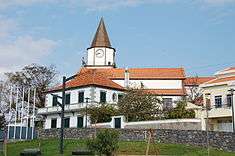 The centre of the parish of Estreito da Calheta | ||
|
||
| Official name: Freguesia do Estreito da Calheta | ||
| Name origin: Portuguese for the strait of the small bay | ||
| Country | ||
|---|---|---|
| Region | ||
| Island | Madeira | |
| Municipality | Calheta | |
| Coordinates | 32°45′28″N 17°10′34″W / 32.75778°N 17.17611°WCoordinates: 32°45′28″N 17°10′34″W / 32.75778°N 17.17611°W | |
| Lowest point | ||
| - elevation | 0 m (0 ft) | |
| Area | 14.32 km2 (6 sq mi) | |
| Population | 1,607 (2011) | |
| Density | 112/km2 (290/sq mi) | |
| LAU | Junta Freguesia | |
| - location | Lombo Serrões, Lombo das Laranjeiras | |
| President Junta | Luís Sardinha Jardim (PPD-PSD) | |
| Timezone | WET (UTC0) | |
| - summer (DST) | WEST (UTC+1) | |
| Postal Zone | 9370-111 | |
| Area Code & Prefix | (+351) 291 XXX XXX | |
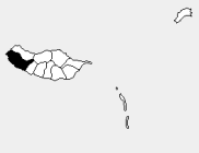 Location of the parish seat of Estreito da Calheta in the municipality of Calheta, island of Madeira | ||
| Wikimedia Commons: Estreito da Calheta | ||

Estreito da Calheta (Portuguese for strait of Calheta) is a civil parish in the municipality of Calheta in the archipelago of Madeira, Portugal. The population in 2011 was 1,607,[1] in an area of 14.32 km².[2]
References
- ↑ Instituto Nacional de Estatística
- ↑ Eurostat Archived September 6, 2014, at the Wayback Machine.
This article is issued from Wikipedia - version of the 11/14/2016. The text is available under the Creative Commons Attribution/Share Alike but additional terms may apply for the media files.