Eußerbach
 | |
| The Eußerbach below Eußerthal | |
| Location | Rhineland-Palatinate, Germany |
|---|---|
| Reference no. | DE: 237726 |
| Length | 11 km |
| Source | on the Armbrunnenkopf, central Palatine Forest |
| Source height | ca. 470 m above sea level (NN) |
| Confluence | with the Dernbach to form the Eisbach 49°13′48″N 7°59′54″E / 49.23000°N 7.99833°E |
| Mouth height | ca. 174 m above sea level (NN) |
| Descent | ca. 296 m |
| Basin | Rhein |
| Progression | Eisbach → Queich → Rhine → North Sea |
| Right tributaries | Eischbach |
| Left tributaries | Sulzbach |
| Reservoirs passed | Schweinswoog trout pond north of Eußerthal |
| Small towns | Annweiler am Trifels |
| Villages | Eußerthal |
The Eußerbach forms the right, northwestern headstream, over 11 kilometres long, of the Eisbach river in the county of Südliche Weinstraße, in the German federal state of Rhineland-Palatinate.
Sights
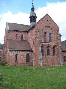
The abbey church of Eußerthal
Abbey Church (Klosterkirche) – The historically most important building in the valley of the Eußerbach is the Romanesque church of St. Bernard which belonged to the former Cistercian abbey of Eußerthal.
Viewing points – The L 505 state road, which climbs from about 170 metres above sea level in the south to heights of over 500 metres, is very picturesque and has several high viewing points. The surrounding area is largely natural.
This article is issued from Wikipedia - version of the 5/17/2016. The text is available under the Creative Commons Attribution/Share Alike but additional terms may apply for the media files.