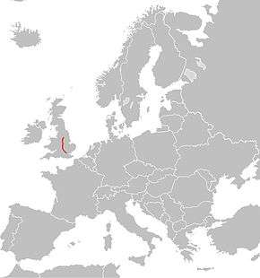
European route E13
| |
|---|---|
 | |
| Route information | |
| Length: | 230 km (140 mi) |
| Major junctions | |
| North end: | Doncaster |
| South end: | London |
| Location | |
| Countries: |
|
| Highway system | |
| International E-road network | |

European route E13 is part of the International E-road network. It runs most of the length of the M1 motorway in the United Kingdom (which runs from South Yorkshire county to its southern terminus in London). The E13 follows the route Doncaster – Sheffield - Nottingham – Leicester – Northampton – Luton – London,[1] and is 277 km (172 mi) long.[2]
Although the United Kingdom government participates fully in the E-road network, E-routes are not signposted within the United Kingdom.[3]
References
- ↑ "European Agreement on Main International Traffic Arteries" (PDF). United Nations Economic and Social Council. 14 March 2008. Retrieved 2010-12-27.
- ↑ As measured using "Calculate your route". ViaMichelin. Retrieved 2011-03-13.
- ↑ For example Economic and Social Council Document ECE/TRANS/WP.6/AC.2/18 - 17 December 2008; Agenda item 6 Participation in the 2005 E-route census
Coordinates: 52°17′12″N 1°06′13″W / 52.2867°N 1.1036°W
This article is issued from Wikipedia - version of the 4/25/2016. The text is available under the Creative Commons Attribution/Share Alike but additional terms may apply for the media files.