Ewing Township, New Jersey
| Ewing Township, New Jersey | ||
|---|---|---|
| Township | ||
| Township of Ewing | ||
|
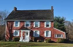
Benjamin Temple House | ||
| ||
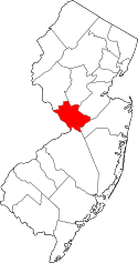
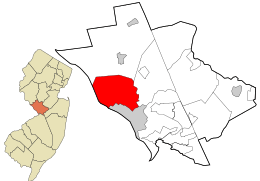 Location in Mercer County and the state of New Jersey. | ||
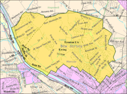 Census Bureau map of Ewing Township, New Jersey | ||
| Coordinates: 40°15′46″N 74°47′54″W / 40.262722°N 74.798307°WCoordinates: 40°15′46″N 74°47′54″W / 40.262722°N 74.798307°W[1][2] | ||
| Country |
| |
| State |
| |
| County | Mercer | |
| Incorporated | February 22, 1834 | |
| Named for | Charles Ewing | |
| Government[3] | ||
| • Type | Faulkner Act (Mayor-Council) | |
| • Body | Township Council | |
| • Mayor | Bert H. Steinmann (D, term ends December 31, 2018)[4][5][6] | |
| • Administrator | James McManimon[7] | |
| • Clerk | Kim J. Macellaro[8] | |
| Area[1] | ||
| • Total | 15.599 sq mi (40.400 km2) | |
| • Land | 15.250 sq mi (39.497 km2) | |
| • Water | 0.349 sq mi (0.903 km2) 2.23% | |
| Area rank |
174th of 565 in state 8th of 12 in county[1] | |
| Elevation[9] | 125 ft (38 m) | |
| Population (2010 Census)[10][11][12] | ||
| • Total | 35,790 | |
| • Estimate (2015)[13] | 36,486 | |
| • Rank |
66th of 565 in state 3rd of 12 in county[14] | |
| • Density | 2,346.9/sq mi (906.1/km2) | |
| • Density rank |
259th of 565 in state 5th of 12 in county[14] | |
| Time zone | Eastern (EST) (UTC-5) | |
| • Summer (DST) | Eastern (EDT) (UTC-4) | |
| ZIP codes | 08560, 08618, 08628, 08638[15][16] | |
| Area code(s) | 609[17] | |
| FIPS code | 3402122185[1][18][19] | |
| GNIS feature ID | 0882128[1][20] | |
| Website |
www | |

Ewing Township is a township in Mercer County, New Jersey, United States. The township is within the New York metropolitan area as defined by the United States Census Bureau.[21] It also directly borders the Philadelphia metropolitan area and is part of the Federal Communications Commission's Philadelphia Designated Market Area.[22] As of the 2010 United States Census, the township's population was 35,790,[10][11][12] reflecting an increase of 83 (+0.2%) from the 35,707 counted in the 2000 Census, which had increased by 1,522 (+4.5%) from the 34,185 counted in the 1990 Census.[23]
History
The earliest inhabitants of present-day Ewing Township in the historic era were Lenni Lenape Native Americans, who lived along the banks of the Delaware River. Their pre-colonial subsistence activities in the area included hunting, fishing, pottery-making, and simple farming. Europeans, mostly from the British Isles, began to colonize the area in the 17th and 18th centuries. One of the earliest European settlers was William Green, and his 1717 farmhouse still stands on the campus of The College of New Jersey.[24]
The area that is now Ewing Township was part of Hopewell Township in what was a very large Burlington County at the beginning of the 18th century. In 1714 Hopewell was removed from Burlington County and added to Hunterdon County.[25][26] By 1719, the area which was to become Ewing Township had been removed from Hopewell Township and added to the newly created Trenton Township.[27] Portions of Trenton Township were incorporated as Ewing Township by an act of the New Jersey Legislature on February 22, 1834, posthumously honoring Charles Ewing for his work as Chief Justice of the New Jersey Supreme Court.[28] The township became part of the newly created Mercer County on February 22, 1838. After incorporation, Ewing Township received additional territory taken from Lawrence Township and the city of Trenton in 1858. In 1894 the city of Trenton took back some of that territory, annexing more in 1900.[29]
When Ewing Township was incorporated in the 19th century, it was primarily farmland with a handful of scattered hamlets, including Carleton (now known as Ewing), Cross Keys (now known as Ewingville), Birmingham (now known as West Trenton) and Greensburg (now known as Wilburtha).[30] Since the beginning of the 20th century, the township has developed as a suburb of Trenton. The sections near the city border are distinctly urban, but most of the township is suburban residential development. The main commercial district extends along North Olden Avenue Extension (County Route 622), originally constructed to connect north Trenton residences with the now-closed General Motors Inland Fisher Guide Plant. Ewing Township today is the location of The College of New Jersey, the Community Blood Council of New Jersey, New Jersey State Police headquarters, the Jones Farm State Correction Institute, the Trenton Psychiatric Hospital, the New Jersey Department of Transportation headquarters, the Katzenbach School for the Deaf and Trenton-Mercer Airport.
From 1953 until 1997 Ewing was the home of Naval Air Warfare Center Trenton, encompassing 528 acres (214 ha) on Parkway Avenue.[31] It was used as a jet engine test facility for the US Navy until its closure based on the recommendations of the 1993 Base Closure and Realignment Commission.[31] Nearly 700 civilian positions were eliminated, most of which were relocated to other facilities in Maryland and Tennessee.[32] The base's Marine operations were transferred to Fort Dix, which has since become Joint Base McGuire-Dix-Lakehurst.[33] A charity to end homelessness acquired the base at no cost in October 2013 in a process involving the United States Department of Defense, the United States Department of Housing and Urban Development, Mercer County and Ewing Township.[33]
The first location of an industrial robot used to replace human workers was at Ewing's Inland Fisher Guide Plant in 1961, a facility that operated in the township for 1938 to 1998, after which the plant was demolished and targeted for redevelopment.[34][35][36]
Geography
According to the United States Census Bureau, the township has a total area of 15.599 square miles (40.400 km2), including 15.250 square miles (39.497 km2) of land and 0.349 square miles (0.903 km2) of water (2.23%).[1][2]
The highest elevation in Ewing Township is 225 feet (69 m) AMSL just east of Interstate 95 and just west of Trenton-Mercer Airport,[37] while the lowest point is just below 20 feet (6.1 m) AMSL along the Delaware River near the border with Trenton.[38]
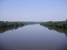
The largest body of water completely within the township is Lake Sylva,[39] a man-made lake that was created in the 1920s when an earthen dam was constructed across the Shabakunk Creek. The 11-acre (4.5 ha) lake is located on the campus of The College of New Jersey.[40] Water courses in Ewing include the Delaware River along its western boundary and the Shabakunk Creek in the eastern and central portions of the township.
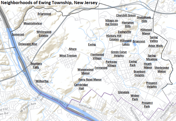
Within the township are a number of distinct neighborhoods. These include Agasote,[41] Altura,[42] Arbor Walk,[43] Braeburn Heights,[43][44][45] Briarcrest,[43][46][47] Briarwood,[43][48][49] Cambridge Hall,[43] Churchill Green,[43][50][51][52] Delaware Rise,[43][50][53][54] Ewing,[41][55] Ewing Park,[56] Ewingville,[43][57][58] Fernwood,[41][59] Ferry Road Manor,[60] Fleetwood Village,[43][50][61][62] Glendale,[41][43][59] Green Curve Heights,[63] Hampton Hills,[43][61][64][65] Heath Manor,[66] Hickory Hill Estates,[43][61][67][68] Hillwood Lakes,[69][70][71][72] Hillwood Manor,[43][61][73][74] Mountainview,[41][43][50][75] Parkway Village,[41][43][61][76] Prospect Heights,[41][43][77][78] Prospect Park,[77][79] Scudders Falls,[41][43][80] Shabakunk Hills,[43][81][82] Sherbrooke Manor,[43][61][83][84] Somerset,[41] Spring Meadows,[43][85][86] Spring Valley,[43] Village on the Green,[43][50][61][87] Weber Park,[77][88][89] West Trenton,[41][43][90][91] Whitewood Estates,[50] Wilburtha[41][43][92][93] and Wynnewood Manor.[43][61][94][95] Some of these existed before suburbanization, while others came into existence with the suburban development of the township in the 20th century.
Neighboring municipalities
 |
Upper Makesfield Township, PA | Hopewell Township | | |
| Lower Makesfield Township, PA | |
Lawrence Township | ||
| ||||
| | ||||
| Yardley, PA | Trenton |
Demographics
| Historical population | |||
|---|---|---|---|
| Census | Pop. | %± | |
| 1840 | 1,017 | — | |
| 1850 | 1,480 | 45.5% | |
| 1860 | 2,079 | 40.5% | |
| 1870 | 2,477 | 19.1% | |
| 1880 | 2,412 | −2.6% | |
| 1890 | 3,129 | 29.7% | |
| 1900 | 1,333 | * | −57.4% |
| 1910 | 1,889 | 41.7% | |
| 1920 | 3,475 | 84.0% | |
| 1930 | 6,942 | 99.8% | |
| 1940 | 10,146 | 46.2% | |
| 1950 | 16,840 | 66.0% | |
| 1960 | 26,628 | 58.1% | |
| 1970 | 32,831 | 23.3% | |
| 1980 | 34,842 | 6.1% | |
| 1990 | 34,185 | −1.9% | |
| 2000 | 35,707 | 4.5% | |
| 2010 | 35,790 | 0.2% | |
| Est. 2015 | 36,486 | [13][96] | 1.9% |
| Population sources: 1840-1920[97] 1840[98] 1850-1870[99] 1850[100] 1870[101] 1880-1890[102] 1890-1910[103] 1910-1930[104] 1930-1990[105] 2000[106][107] 2010[10][11][12] * = Lost territory in previous decade.[108] | |||
Census 2010
At the 2010 United States Census, there were 35,790 people, 13,171 households, and 7,982 families residing in the township. The population density was 2,346.9 per square mile (906.1/km2). There were 13,926 housing units at an average density of 913.2 per square mile (352.6/km2). The racial makeup of the township was 63.14% (22,598) White, 27.62% (9,885) Black or African American, 0.30% (109) Native American, 4.30% (1,538) Asian, 0.04% (15) Pacific Islander, 2.24% (803) from other races, and 2.35% (842) from two or more races. Hispanics or Latinos of any race were 7.62% (2,727) of the population.[10]
There were 13,171 households, of which 22.3% had children under the age of 18 living with them, 43.0% were married couples living together, 13.2% had a female householder with no husband present, and 39.4% were non-families. 30.5% of all households were made up of individuals, and 11.5% had someone living alone who was 65 years of age or older. The average household size was 2.40 and the average family size was 2.97.[10]
In the township, 16.3% of the population were under the age of 18, 20.0% from 18 to 24, 23.0% from 25 to 44, 25.9% from 45 to 64, and 14.7% who were 65 years of age or older. The median age was 37.2 years. For every 100 females there were 88.7 males. For every 100 females age 18 and over, there were 85.9 males.[10]
The Census Bureau's 2006-2010 American Community Survey showed that (in 2010 inflation-adjusted dollars) median household income was $69,716 (with a margin of error of +/- $2,668) and the median family income was $86,875 (+/- $4,312). Males had a median income of $56,308 (+/- $6,003) versus $52,313 (+/- $1,887) for females. The per capita income for the borough was $30,489 (+/- $1,527). About 4.7% of families and 10.0% of the population were below the poverty line, including 7.3% of those under age 18 and 6.4% of those age 65 or over.[109]
Census 2000
As of the 2000 United States Census[18] there were 35,707 people, 12,551 households, and 8,208 families residing in the township. The population density was 2,328.6 people per square mile (899.3/km2). There were 12,924 housing units at an average density of 842.8 per square mile (325.5/km2). The racial makeup of the township was 69.02% White, 24.82% African American, 0.15% Native American, 2.27% Asian, 0.06% Pacific Islander, 1.83% from other races, and 1.84% from two or more races. Hispanic or Latino of any race were 4.44% of the population.[106][107]
There were 12,551 households out of which 25.3% had children under the age of 18 living with them, 49.7% were married couples living together, 12.2% had a female householder with no husband present, and 34.6% were non-families. 27.7% of all households were made up of individuals and 12.1% had someone living alone who was 65 years of age or older. The average household size was 2.45 and the average family size was 3.00.[106][107]
In the township the population was spread out with 18.0% under the age of 18, 17.3% from 18 to 24, 26.8% from 25 to 44, 22.1% from 45 to 64, and 15.8% who were 65 years of age or older. The median age was 37 years. For every 100 females there were 93.0 males. For every 100 females age 18 and over, there were 90.0 males.[106][107]
The median income for a household in the township was $57,274, and the median income for a family was $67,618. Males had a median income of $44,531 versus $35,844 for females. The per capita income for the township was $24,268. About 3.3% of families and 6.4% of the population were below the poverty line, including 5.4% of those under age 18 and 7.1% of those age 65 or over.[106][107]
Economy
In mid–2013, Celator Pharmaceuticals established an office presence in Ewing.[110]
Ewing's decommissioned Marine Reserve Center will be the headquarters of HomeFront, a charity dedicated to ending homelessness in the Mercer region, with construction starting summer 2014, including a shelter, job training and literacy programs, day care, computer rooms and a teaching kitchen.[33]
Government
Local government
Ewing Township is governed under the Faulkner Act, formally known as the Optional Municipal Charter Law, within Mayor-Council plan 2 form of New Jersey municipal government, as implemented as of January 1, 1995, based on the recommendations of a Charter Study Commission.[111] The Governing Body of the township consists of five Council members and a Mayor, all of whom are elected by the voters of the community. The Mayor and Members of the Council are elected at-large to four-year terms of office, with either three seats up for election or two seats and the mayoral seat every other year.[3][112]
As of 2016, the Mayor of Ewing Township is Democrat Bert H. Steinmann, whose term of office ends December 31, 2018.[4] Members of the Ewing Township Council are Council President David P. Schroth (D, 2016), Vice President Sarah Steward (D, 2018), Kevin Baxter (D, 2016), Jennifer L. Keyes-Maloney (D, 2016) and Kathy Culliton Wollert (D, 2018).[113][114][115][116][117][118]
Federal, state and county representation
Ewing Township is located in the 12th Congressional District[119] and is part of New Jersey's 15th state legislative district.[11][120][121]
New Jersey's Twelfth Congressional District is represented by Bonnie Watson Coleman (D, Ewing Township).[122] New Jersey is represented in the United States Senate by Cory Booker (D, Newark, term ends 2021)[123] and Bob Menendez (D, Paramus, 2019).[124][125]
For the 2016–2017 session (Senate, General Assembly), the 15th Legislative District of the New Jersey Legislature is represented in the State Senate by Shirley Turner (D, Lawrence Township, Mercer County) and in the General Assembly by Reed Gusciora (D, Trenton) and Elizabeth Maher Muoio (D, Pennington).[126] The Governor of New Jersey is Chris Christie (R, Mendham Township).[127] The Lieutenant Governor of New Jersey is Kim Guadagno (R, Monmouth Beach).[128]
Mercer County is governed by a County Executive who oversees the day-to-day operations of the county and by a seven-member Board of Chosen Freeholders that acts in a legislative capacity, setting policy. All officials are chosen at-large in partisan elections, with the executive serving a four-year term of office while the freeholders serve three-year terms of office on a staggered basis, with either two or three seats up for election each year.[129] As of 2014, the County Executive is Brian M. Hughes (D, term ends December 31, 2015; Princeton).[130] Mercer County's Freeholders are Freeholder Chair Andrew Koontz (D, 2016; Princeton),[131] Freeholder Vice Chair Samuel T. Frisby, Sr. (2015; Trenton),[132] Ann M. Cannon (2015; East Windsor Township),[133] Anthony P. Carabelli (2016; Trenton),[134] John A. Cimino (2014, Hamilton Township),[135] Pasquale "Pat" Colavita, Jr. (2015; Lawrence Township)[136] and Lucylle R. S. Walter (2014; Ewing Township)[137][138][139] Mercer County's constitutional officers are County Clerk Paula Sollami-Covello (D, 2015),[140] Sheriff John A. Kemler (D, 2014)[141] and Surrogate Diane Gerofsky (D, 2016).[142][5]
The New Jersey Juvenile Justice Commission has its headquarters in the township.[143][144]
Politics
As of March 23, 2011, there were a total of 21,714 registered voters in Ewing Township, of which 9,358 (43.1%) were registered as Democrats, 3,256 (15.0%) were registered as Republicans and 9,087 (41.8%) were registered as Unaffiliated. There were 13 voters registered to other parties.[145]
In the 2012 presidential election, Democrat Barack Obama received 73.0% of the vote (11,910 cast), ahead of Republican Mitt Romney with 25.8% (4,218 votes), and other candidates with 1.2% (190 votes), among the 17,947 ballots cast by the township's 23,230 registered voters (1,629 ballots were spoiled), for a turnout of 77.3%.[146][147] In the 2008 presidential election, Democrat Barack Obama received 70.0% of the vote (11,911 cast), ahead of Republican John McCain with 28.1% (4,787 votes) and other candidates with 1.2% (200 votes), among the 17,021 ballots cast by the township's 22,913 registered voters, for a turnout of 74.3%.[148] In the 2004 presidential election, Democrat John Kerry received 62.0% of the vote (10,091 ballots cast), outpolling Republican George W. Bush with 34.7% (5,653 votes) and other candidates with 0.6% (135 votes), among the 16,284 ballots cast by the township's 22,019 registered voters, for a turnout percentage of 74.0.[149]
In the 2013 gubernatorial election, Democrat Barbara Buono received 53.7% of the vote (5,279 cast), ahead of Republican Chris Christie with 44.7% (4,395 votes), and other candidates with 1.7% (163 votes), among the 10,070 ballots cast by the township's 22,876 registered voters (233 ballots were spoiled), for a turnout of 44.0%.[150][151] In the 2009 gubernatorial election, Democrat Jon Corzine received 59.4% of the vote (6,529 ballots cast), ahead of Republican Chris Christie with 34.1% (3,751 votes), Independent Chris Daggett with 4.7% (520 votes) and other candidates with 0.7% (81 votes), among the 10,989 ballots cast by the township's 22,263 registered voters, yielding a 49.4% turnout.[152]
Education
The Ewing Township Board of Education oversees the Ewing Public Schools. As of the 2011-12 school year, the district's five schools had an enrollment of 3,704 students and 302.7 classroom teachers (on an FTE basis), for a student–teacher ratio of 12.24:1.[153] Schools in the district (with 2011-12 enrollment data from the National Center for Education Statistics[154]) are three K-5 elementary schools — W. L. Antheil Elementary School[155] (670 students; in grades PreK-5), Francis Lore Elementary School[156] (516; K-5) and Parkway Elementary School[157] (465; K-5) — Gilmore J. Fisher Middle School[158] (929) for grades 6-8 and Ewing High School[159] (1,124) for grades 9-12.[160][161]
A court case filed in 1946 challenged a policy of the Ewing Public Schools under which the district provided bus transportation to students living in the districts who attended private parochial schools. In Everson v. Board of Education, the Supreme Court of the United States ruled for the first time that state and local government were subject to the Establishment Clause of the First Amendment to the United States Constitution, but that it had not been violated in this instance.[162]
The Ewing Public Education Foundation, established in 1995, is an independent, not-for-profit citizen's organization whose mission is to mobilize community support, concern, commitment and resources to help improve the quality of education in Ewing Township. EPEF provides grants to Ewing Township Schools for innovative educational programs through fund-raising activities, and corporate and institutional sponsorship. The Foundation also seeks to match corporate and organizational donors with teachers to fund additional projects of mutual interest. These programs enhance the educational experience without the use of additional taxpayer dollars.[163]
The Mercer County Vocational School District's Thomas J. Rubino Academy (formerly Mercer County Alternative High School) is one of Mercer County's only alternative schools, offering an alternative educational program for students who have struggled in the traditional school environment, featuring smaller classes, mentoring and counseling.[164]
The Marie H. Katzenbach campus of the New Jersey School for the Deaf serves 175 hearing-impaired students on a campus covering 148 acres (60 ha) that was opened in West Trenton in 1926.[165][166] The school was established in Ewing through the efforts of Marie Hilson Katzenbach and was renamed in her honor in 1965.[167]
Incarnation-St. James Catholic School (formerly Incarnation School), constructed in 1955, is a Pre-K to 8th grade parish school administered by The Sisters, Servants of the Immaculate Heart of Mary and overseen by the Roman Catholic Diocese of Trenton.[168] The school added a parish center in 2003, which includes a gym, locker rooms, offices, meeting rooms, boiler room, and a kitchenette to be used to the benefit of its students, faculty, and staff. In 2006, the Incarnation School and parish combined with the St. James School and parish.[169]
The Villa Victoria Academy is a private Catholic school in Ewing Township, christened as a private academy in 1933, and operated by the Religious Teachers Filippini. This single-gender school offers an education to young women from pre-Kindergarten to twelfth grade.[170]
The College of New Jersey (formerly Trenton State College) is located on a campus covering 289 acres (117 ha) within the township.[171]
Transportation
Ewing Township is traversed by multiple main roadways, as well as by a passenger rail line and is the location of an airport.
Roads and highways
_in_Ewing%2C_New_Jersey.JPG)
As of May 2010, the township had a total of 149.74 miles (240.98 km) of roadways, of which 108.73 miles (174.98 km) were maintained by the municipality, 28.16 miles (45.32 km) by Mercer County, 12.65 miles (20.36 km) by the New Jersey Department of Transportation, which also has its headquarters in Ewing, and 0.20 miles (0.32 km) by the Delaware River Joint Toll Bridge Commission.[172]
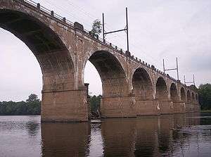
Interstate 95 (the Scudder Falls Freeway and Bridge) crosses the northwestern section of the township. It is a 55 to 65 miles per hour (89 to 105 km/h), 4-6 lane divided freeway facility. It was constructed as a 4-lane facility in the 1960s, and widened to 6 lanes in the 1990s, with the exception of the Scudder Falls Bridge over the Delaware River. It connects south with Philadelphia, Pennsylvania and connects north to U.S. 1, where this branch of Interstate 95 ends and becomes Interstate 295. From there, travelers use U.S. 1 or Interstate 195 and the New Jersey Turnpike to reach the next major destination northwards, New York City. The Ewing portion of Interstate 95 will eventually be redesignated as Interstate 295 when a direct interchange between Interstate 95 in Pennsylvania and the Pennsylvania Turnpike is completed,[173] re-routing Interstate 95 onto the New Jersey Turnpike at Exit 6 (in Mansfield Township).
U.S. Route 206 (Princeton Avenue) skirts the southeastern section of the township. It is a 25 miles per hour (40 km/h), undivided four-lane[174] facility. Although part of US 206, it is actually maintained by the Mercer County Department of Transportation as part of County Route 583, which is co-signed with US 206. US 206 also connects south to Trenton, and connects north to Princeton and Somerville.
_and_River_Road_(New_Jersey_Route_175)_from_the_West_Trenton_Railroad_Bridge_in_Ewing%2C_New_Jersey.JPG)
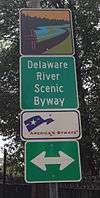
Route 29 (Daniel Bray Highway and River Road) extends north-south along the western edge of the township, along the Delaware River. The southern section, Daniel Bray Highway, is a 55 mph (90 km/h), divided four-lane facility with at-grade intersections and traffic lights, and was constructed in the 1950s. The northern section, River Road, is a 45 mph (70 km/h), undivided two-lane facility whose construction as a state highway dates from the 1930s. NJ 29 connects southwards to Trenton, and northwards to Lambertville and Frenchtown. The entire section of Route 29 in Ewing is designated the Delaware River Scenic Byway, a National Scenic Byway. Route 175 serves as a frontage road along the divided portion of Route 29.
Route 31 (Pennington Road) extends north-south towards the eastern side of the township. It is a 35-45 mph (60–70 km/h), undivided four-lane facility whose construction as a state highway also dates to the 1930s. It once also carried a trolley line, but it has long since been removed. It was once proposed to be bypassed by a freeway, but this plan has since been cancelled. NJ 31 also connects south to Trenton, and connects north to Pennington, Flemington, and Clinton.
Public transportation
The West Trenton Station is at the terminus of SEPTA's West Trenton Line. This commuter rail facility mainly serves commuter traffic to and from Philadelphia. New Jersey Transit has proposed a new West Trenton Line of its own, that would stretch for 27 miles (43 km) from the West Trenton Station to a connection with the Raritan Valley Line at Bridgewater Township, and from there to Newark Penn Station in Newark.[175][176]
Ewing Township is the site of the Trenton-Mercer Airport (TTN), which first opened in 1929 and is one of three commercial airports in the state. The airport has 100,000 takeoffs and landings annually, and is served by Frontier Airlines, which offers nonstop service to and from 10 different locations nationwide.[177]
Ewing Township is also traversed by the Delaware and Raritan Canal near the Delaware River. Originally important to commerce and trade, the advent of railroads caused the canal's commercial demise. The strip of land along the canal is currently part of the Delaware and Raritan Canal State Park.
New Jersey Transit provides service between the township and Trenton on the 601, 602, 607, 608 and 609 routes.[178]
Points of interest
- The William Greene Farmhouse was the home of Judge William Greene, who was born in the 1600s in England and died in 1722 in Hunterdon County, New Jersey.[179] The William Green House is on the U.S. National Register of Historic Places and the New Jersey Register of Historic Places.
- Delaware and Raritan Canal - Runs along the eastern bank of the Delaware River in western Ewing Township.
- Washington Victory Trail - Documents the trail taken by George Washington's army during the American Revolution on December 26, 1776. This led to a successful surprise attack on the Hessian troops occupying Trenton, New Jersey. Victory trail begins in nearby Washington Crossing State Park, enters Ewing Township at Jacobs Creek Road and continues along Bear Tavern Road. General Sullivan's route follows Grand Avenue and Sullivan Way to Trenton. General Greene's route follows Parkway Avenue to Trenton.[180][181]
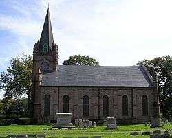
- Ewing Presbyterian Church is an historic building dated 1867 and set within the American Revolution era Ewing Church Cemetery. It is the fourth church to be built in the cemetery grounds. The current church building has been under threat of demolition after several engineering studies found the roof trusses are buckling and beyond the point of cost effective repair. Numerous preservation groups say that the structural problems are much easier to resolve than the studies claim. Various organizations have endeavored to raise funds to secure the stability of the original church structure.[182]
- Our Lady of Good Counsel Church, located on W. Upper Ferry Road, is a Roman Catholic church built in the early 1960s to meet the growing needs of the rapidly expanding township. Its architecture is similar to Saint Paul's Church in Princeton. The Church is a major worship center for the Catholic community in what is called the West Trenton section of the township.[183]
- Louis Kahn's Trenton Bath House was an early work of the influential mid-twentieth century architect, made for the Trenton Jewish Community Center (now the Ewing Senior & Community Center).[184]
- The offices and studios of radio station WKXW, "New Jersey 101.5", are located in Ewing.[185]
Notable people
People who were born in, residents of, or otherwise closely associated with Ewing Township include:
- Pierre Bernard, graphic designer and comedian for Late Night with Conan O'Brien on which he hosts the segment "Pierre Bernard's Recliner of Rage".[186]
- Bonnie Watson Coleman (born 1945), politician, who has served in the New Jersey General Assembly since 1998, where she represents the 15th Legislative District.[187]
- Hollis Copeland (born 1955), former basketball player with the New York Knicks.[188]
- Steve Garrison (born 1986), Major League Baseball relief pitcher who played for the New York Yankees.[189]
- William M. Lanning (1849-1912), Republican Party politician who represented New Jersey's 4th congressional district in the United States House of Representatives from 1903 to 1904.[190]
- Dick LaRossa (born 1946), politician who served two terms in the New Jersey Senate, from 1994 to 2000, where he represented the 15th Legislative District.[191]
- Glenn K. Rieth, former Adjutant General of New Jersey (2002-2011).[192][193]
- Albert C. Wagner (1911-1987), director of the New Jersey Department of Corrections from 1966 to 1973.[194]
References
- 1 2 3 4 5 6 2010 Census Gazetteer Files: New Jersey County Subdivisions, United States Census Bureau. Accessed May 21, 2015.
- 1 2 US Gazetteer files: 2010, 2000, and 1990, United States Census Bureau. Accessed September 4, 2014.
- 1 2 2012 New Jersey Legislative District Data Book, Rutgers University Edward J. Bloustein School of Planning and Public Policy, March 2013, p. 73.
- 1 2 Mayor's Message, Ewing Township. Accessed July 11, 2016.
- 1 2 Elected Officials for Mercer County, State of New Jersey. Accessed September 6, 2014.
- ↑ 2016 New Jersey Mayors Directory, New Jersey Department of Community Affairs. Accessed June 14, 2016. As of date accessed, Steinmann was listed as mayor with an incorrect term-end year of 2016.
- ↑ Administration, Ewing Township. Accessed July 11, 2016.
- ↑ Municipal Clerk, Ewing Township. Accessed July 11, 2016.
- ↑ U.S. Geological Survey Geographic Names Information System: Township of Ewing, Geographic Names Information System. Accessed March 5, 2013.
- 1 2 3 4 5 6 DP-1 - Profile of General Population and Housing Characteristics: 2010 for Ewing township, Mercer County, New Jersey, United States Census Bureau. Accessed November 18, 2012.
- 1 2 3 4 Municipalities Grouped by 2011-2020 Legislative Districts, New Jersey Department of State, p. 7. Accessed January 6, 2013.
- 1 2 3 Profile of General Demographic Characteristics: 2010 for Ewing township, New Jersey Department of Labor and Workforce Development. Accessed November 18, 2012.
- 1 2 PEPANNRES - Annual Estimates of the Resident Population: April 1, 2010 to July 1, 2015 - 2015 Population Estimates for New Jersey municipalities, United States Census Bureau. Accessed May 22, 2016.
- 1 2 GCT-PH1 Population, Housing Units, Area, and Density: 2010 - State -- County Subdivision from the 2010 Census Summary File 1 for New Jersey, United States Census Bureau. Accessed November 18, 2012.
- ↑ Look Up a ZIP Code for Ewing, NJ, United States Postal Service. Accessed January 23, 2012.
- ↑ Zip Codes, State of New Jersey. Accessed October 11, 2013.
- ↑ Area Code Lookup - NPA NXX for Ewing, NJ, Area-Codes.com. Accessed October 11, 2013.
- 1 2 American FactFinder, United States Census Bureau. Accessed September 4, 2014.
- ↑ A Cure for the Common Codes: New Jersey, Missouri Census Data Center. Accessed October 28, 2012.
- ↑ US Board on Geographic Names, United States Geological Survey. Accessed September 4, 2014.
- ↑ New York-Newark, NY-NJ-CT-PA Combined Statistical Area, United States Census Bureau. Accessed December 28, 2014.
- ↑ - Philadelphia Market Area Coverage Maps, Federal Communications Commission. Accessed December 28, 2014.
- ↑ Table 7. Population for the Counties and Municipalities in New Jersey: 1990, 2000 and 2010, New Jersey Department of Labor and Workforce Development, February 2011. Accessed November 18, 2012.
- ↑ About the Farmhouse, Friends of the Wm Green Farmhouse. Accessed January 7, 2015. "The house today mirrors the area's architectural history with sections from three distinct building periods. Circa 1717 to 1730 section: The oldest remaining section, is the southeast segment of the building. This was originally a 2 ½ story brick house. The fine Flemish bond brickwork of this section is similar to that used in the 1719 Trent House in Trenton. Its interior preserves original 18th-century detailing. Circa 1750 to 1790 section: The second oldest section, added as the Green family grew, is located behind the oldest portion. It forms the northeast segment of the house and added four rooms and a stair hall. Circa 1830 section: The third building stage, a two-room-deep brick addition to the west, nearly doubled the size of the house."
- ↑ The Story of New Jersey's Civil Boundaries: 1606-1968, Bureau of Geology and Topography; Trenton, New Jersey; 1969. p. 52. Accessed January 7, 2015. "Hopewell township: From Burlington Court records, February 20, 1699/1700: The Hopewell township boundaries were "To begin at Mahlon Stacyes Mill [at what is now Trenton] And so along by York:road, until it comes to Shabbucunck, and up the same until it meet with the line of Partition that divides the Societies 30000 acres Purchase from the 15000 and then along the line of said Societies 30000 acres Purchase to Delaware River."
- ↑ The Story of New Jersey's Civil Boundaries: 1606-1968, Bureau of Geology and Topography; Trenton, New Jersey; 1969. p. 162. Accessed January 7, 2015.
"Hopewell township
1700 Feb 20, item 227: Formed in Burlington Co.
1714 item 4: Set off to Hunterdon Co.
1719 item 332: Part mentioned as Trenton (twp.)" - ↑ The Story of New Jersey's Civil Boundaries: 1606-1968, Bureau of Geology and Topography; Trenton, New Jersey; 1969. p. 164-165. Accessed January 7, 2015.
"Trenton township
1719 June 3, item 332: Mentioned. Constable appointed for Hunterdon Co.
1720 Mar. 2, item 371: Boundary recorded.
1792 item 116: Part incorp. as Trenton city.
1798 Feb. 21, item 289: Incorporated.
1831 item 112: Part from Trenton city.
1834 item 102: Part to Ewing twp." - ↑ Hutchinson, Viola L. The Origin of New Jersey Place Names, New Jersey Public Library Commission, May 1945. Accessed August 30, 2015.
- ↑ The Story of New Jersey's Civil Boundaries: 1606-1968, Bureau of Geology and Topography; Trenton, New Jersey; 1969. p. 161-162. Accessed January 7, 2015.
"Ewing township
1834 Feb. 22, item 102: Formed from Trenton twp. in Hunterdon Co.
1838 item 99: Set off to Mercer Co.
1858 item 44: Part from Trenton city.
1858 item 403: Part from Lawrence twp.
1894 item 595: Part to Trenton city.
1900 item 282: Part to Trenton city." - ↑ History of Ewing, Township of Ewing. Accessed April 20, 2015. "In the early years of settlement, Ewing was chiefly a woodland area; however, after the Revolution, Ewing embarked upon a long period of agricultural growth and activity. In 1844, historians Barber and Howe described the Township as having some of the richest soil in New Jersey. Early development was in the form of small hamlets scattered throughout the Township, including Birmingham (now known as West Trenton), Ewing, Ewingville, and Greensburg (now Wilburtha)."
- 1 2 Former Naval Air Warfare Center Trenton, United States Navy. Accessed October 28, 2014. "The former Naval Air Warfare Center (NAWC) Trenton is located in Ewing Township, New Jersey."
- ↑ Staff. "Base-Closing Panel Wraps Up Five Days of Voting", The New York Times, June 28, 1993. Accessed October 11, 2013. "Under the panel's plan for the Ewing unit, the Naval Air Warfare Center, Aircraft Division, would be divided between the Arnold Engineering Center in Tullahoma, Tenn., and the Naval Air Warfare Center at Patuxent River, Md.... Officials were unclear how many people would lose their jobs because of the closing. The Ewing base employs 680 civilians and seven military workers, of whom 157 engineers and other high-level personnel are already awaiting transfer to Patuxent River as part of a 1991 base-closing decision."
- 1 2 3 McGrath, Brendan. "HomeFront charity to take over Marine Reserve Center in Ewing", The Times (Trenton), June 16, 2014. Accessed October 28, 2014. "HomeFront, the charity dedicated to ending homelessness in the Mercer region, will soon begin construction on its new headquarters as it takes over the decommissioned Marine Reserve Center in Ewing.... The Marine operations at the base were transferred to Fort Dix, which has since become Joint Base McGuire-Dix-Lakehurst."
- ↑ Mickle, Paul. "1961: A peep into the automated future", The Trentonian. Accessed January 17, 2015. "Without any fanfare, the world's first working robot joined the assembly line at the General Motors plant in Ewing Township in the spring of 1961."
- ↑ Famous Firsts in New Jersey, State of New Jersey. Accessed January 18, 2015. "The first robot to replace a human worker was used by General Motors in Ewing Township in 1961."
- ↑ Galler, Joan. "Ewing's vacant General Motors site soon to be cleaned", The Trentonian, August 10, 2011. Accessed January 18, 2015.
- ↑ Interchange 2 USGS Pennington Quad, NJ,PA, Topographic Map, TopoZone. Accessed November 18, 2012.
- ↑ USGS Trenton West Quad, NJ,PA, Topographic Map, TopoZone. Accessed November 18, 2012.
- ↑ "Environmental Resource Inventory for the Township of Ewing, Mercer County, New Jersey" (PDF). Retrieved May 27, 2013.
There are two major lakes in Ewing Township: Lake Ceva and Lake Sylva. These open bodies of water are permanent waters and were created by damming Shabakunk Creek. Although they are classified as true lakes by federal and state maps, these lakes are man-made impoundments. Lake Sylva covers 10.6 acres and Lake Ceva covers 6.4 acres.
- ↑ USGS 01463740 Shabakunk C at Sylva Lake Dam at Ewingville NJ, United States Geological Survey. Accessed October 11, 2013.
- 1 2 3 4 5 6 7 8 9 10 11 Locality Search, State of New Jersey. Accessed January 25, 2015.
- ↑ Google (January 9, 2015). "Altura, New Jersey" (Map). Google Maps. Google. Retrieved January 9, 2015.
- 1 2 3 4 5 6 7 8 9 10 11 12 13 14 15 16 17 18 19 20 21 22 23 24 25 "Ewing New Jersey Neighborhoods". Weidel Realtors. Retrieved April 24, 2015.
- ↑ Google (January 9, 2015). "Braeburn Heights, New Jersey" (Map). Google Maps. Google. Retrieved January 9, 2015.
- ↑ "Brae Burn Heights, Ewing Township, New Jersey". livingplaces.com. Retrieved 2015-01-18.
Brae Burn Heights (also known as Brae Burn Park) is a residential neighborhood of detached, single family homes built from the 1940s through the 1970s. Median lot size is less than 1/5th of an acre. The Brae Burn Heights neighborhood is generally bounded by Parkside Avenue, Pennington Road, Somerset Street and Buttonwood Drive.
- ↑ "Briarcrest". Living Places. Retrieved February 26, 2015.
- ↑ "Briarcrest, Ewing". Weichert Realtors. Retrieved February 26, 2015.
- ↑ "The Briarwood Development". Remax New Jersey. Retrieved March 20, 2015.
- ↑ "Ewing New Jersey Homes". Weidel Realtors. Retrieved March 20, 2015.
Briarwood was built in 1975. There are 54 homes in this neighborhood of Ewing.
- 1 2 3 4 5 6 "Neighborhoods in Mercer County New Jersey". Living Places. Retrieved February 26, 2015.
- ↑ "Churchill Green, Ewing". Berkshire Hathaway Home Services. Retrieved February 26, 2015.
- ↑ "Churchill Green, Ewing". Weichert Realtors. Retrieved February 26, 2015.
- ↑ "Delaware Rise, Ewing". Berkshire Hathaway Home Services. Retrieved February 26, 2015.
- ↑ "Delaware Rise, Ewing". Weichert Realtors. Retrieved February 26, 2015.
- ↑ Jo Ann Tesauro (2002). Images of America: Ewing Township. Arcadia Publishing. p. 8. ISBN 0-7385-1040-8.
The Carleton/Ewing/Ewing Presbyterian Church area was a small village at the intersection of today's Upper Ferry and Scotch Roads and the lands to the north, where the railroad crosses Scotch Road. It contained nine homesteads, a blacksmith, a wheelwright shop, a church and a flour mill.
- ↑ "Relationship between TCNJ off-campus students, Ewing residents improving". nj.com. Retrieved March 20, 2015.
In September and October, Russell said TCNJ students were their usual rowdy selves in the Ewing Park neighborhood just south of campus, off Green Lane.
- ↑ Jo Ann Tesauro (2002). Images of America: Ewing Township. Arcadia Publishing. p. 8. ISBN 0-7385-1040-8.
Cross Keys/Ewingville was a village with its main intersection at today's Pennington, Ewingville and Upper Ferry Roads. This bustling town was named after William Green's Cross Keys Inn, located on the northeast corner of the intersection in the 1700s.
- ↑ Jo Ann Tesauro (2002). Images of America: Ewing Township. Arcadia Publishing. p. 64. ISBN 0-7385-1040-8.
In the 1700s and part of 1800s, this village was called Cross Keys, as was the hotel at its main intersection. In 1836, after the incorporation of Ewing Township in 1834, the village became known as Ewingville.
- 1 2 "History of Ewing". Township of Ewing. Retrieved February 26, 2015.
Despite the early development of the streetcar suburbs, Ewing grew slowly in the first quarter of the 20th century: by 1920 the population of the Township stood at 3500. The area remained predominantly rural in nature until just prior to World War II, when new industries would begin a long period of growth and development for the Township. With the construction of the General Motors plant in 1938 and the employment opportunities that accompanied it, new communities such as the Glendale and Fernwood began to be built. By 1940, only twenty years later, the Township's population had almost tripled to 10,146.
- ↑ Google (January 9, 2015). "Ferry Road Manor, New Jersey" (Map). Google Maps. Google. Retrieved January 9, 2015.
- 1 2 3 4 5 6 7 8 "History of Ewing". Township of Ewing. Retrieved February 26, 2015.
After World War II Ewing Township grew rapidly, reflected by the construction of a variety of housing, including Parkway Village, Moss Homes, Wynnwood Manor and Fleetwood Village. Later subdivisions include Hampton Hill, Hillwood Manor, Sherbrooke, Hickory Hills and Village on the Green. By 1960, the population of the Township had grown to 26,828.
- ↑ "Fleetwood Village, Ewing". Weichert Realtors. Retrieved February 26, 2015.
- ↑ Google (January 9, 2015). "Green Curve Heights, New Jersey" (Map). Google Maps. Google. Retrieved January 9, 2015.
- ↑ "Hampton Hills". Living Places. Retrieved February 26, 2015.
- ↑ "Hampton Hills, Ewing". Weichert Realtors. Retrieved February 26, 2015.
- ↑ Google (January 9, 2015). "Heath Manor, New Jersey" (Map). Google Maps. Google. Retrieved January 9, 2015.
- ↑ "Hickory Hill Estates". Living Places. Retrieved February 26, 2015.
- ↑ "Hickory Hill Estates, Ewing". Weichert Realtors. Retrieved February 26, 2015.
- ↑ "Environmental Resource Inventory for the Township of Ewing, Mercer County, New Jersey (page 83)" (PDF). Delaware Valley Regional Planning Commission. Retrieved March 26, 2015.
- ↑ "1933: The genius next door". The Trentonian. Retrieved March 26, 2015.
The New Jersey State Teacher College moved out of Trenton and into the campus of red-brick halls in the Hillwood Lakes section of Ewing. Later, the school would be renamed Trenton State College; In 1996, it became the College of New Jersey.
- ↑ "Lake Ceva be dammed". The Signal. Retrieved March 26, 2015.
Deborah Knox, associate professor of computer science, and her husband Dan, residents of the local Hillwood Lakes community in Ewing, brought up several concerns. Deborah Knox walks to the College and was concerned that the walkway she traverses each day would be obstructed by the work.
- ↑ "The College of New Jersey". StateUniversity.com. Retrieved March 26, 2015.
The campus itself is a quiet oasis within bustling Ewing Township, closed to outside traffic and encircled by Metzger Drive, a two-mile loop popular with joggers, walkers, and bikers. An abundance of trees and the bordering Hillwood Lakes—Lake Sylva and Lake Ceva—give the campus a natural, pristine feel, despite its location in the heart of suburban New Jersey.
- ↑ "Hillwood Manor". Living Places. Retrieved February 26, 2015.
- ↑ "Hillwood Manor, Ewing". Weichert Realtors. Retrieved February 26, 2015.
- ↑ "Mountainview, Ewing Township, New Jersey". livingplaces.com. Retrieved January 18, 2015.
Mountainview is a residential neighborhood with homes built primarily during the 1960s and 1970s. Median age is ca. 1963. Typical homes are 3-4 bedrooms, 1-1/2 to 2-1/2 baths, most having garages (1, 2 or 3-car). Median lot size is approximately 1/2 acre. Median interior living space is approximately 2,300 sq. ft. The neighborhood boundaries are generally, Jacobs Creek Road on the north and Mountainview Road on the south.
- ↑ "Parkway Village, Ewing Township, New Jersey". livingplaces.com. Retrieved 2015-01-18.
Parkway Village is a residential development of detached, single family homes built primarily during the 1940s and 1950s. Median age is ca. 1952. Median interior living space is approximately 1,400 sq. ft. Median lot size is less than 1/5th of an acre. Access to the Parkway Village neighborhood is from Lower Ferry Road onto Terrace Boulevard, Fireside Drive or Winthrop Avenue; from Parkway Avenue onto Stratford Avenue, Rutledge Avenue, Dunmore Avenue or Farrell Drive.
- 1 2 3 "History of Ewing". Township of Ewing. Retrieved February 26, 2015.
By the early 20th century, Trenton had become a major industrial center, and the population of the city rapidly increased. The areas of Ewing adjacent to Trenton began to take on urban characteristics, absorbing the population overflow from the city. Many Trenton residents discovered the advantages of living in Ewing, and the Township began to change from an agricultural to a residential community. Trains and streetcars enabled people to live further from the center of Trenton. Areas such as Homecrest, Prospect Heights, Prospect Park, and Weber Park were established near the borders of the City of Trenton, some of the earliest 'suburban' developments in Ewing.
- ↑ "Prospect Heights, Ewing Township, New Jersey". livingplaces.com. Retrieved January 18, 2015.
Prospect Heights is a residential neighborhood of detached, single family homes most of which were built from the 1920s through the 1970s. Median age is ca. 1953. Median lot size is less than 1/5th of an acre. Median interior living space is approximately 1,500 sq. ft. Homes are typically 2 to 4 bedrooms with 1 to 2 baths; about 2/3rds of the homes have full basements; approximately half of the homes have garages. Access to the Prospect Heights neighborhood is from Olden Avenue North onto 5th, 6th or Prospect Streets; from Parkside Avenue onto Buttonwood Drive; from Spruce Street onto Prospect Street.
- ↑ Google (January 9, 2015). "Prospect Park, New Jersey" (Map). Google Maps. Google. Retrieved January 9, 2015.
- ↑ "Scudders Falls". American Whitewater. Retrieved February 4, 2015.
- ↑ "Shabakunk Hills". Living Places. Retrieved February 26, 2015.
- ↑ "Shabakunk Hills, Ewing". Berkshire Hathaway Home Services. Retrieved February 26, 2015.
- ↑ "Sherbrooke Manor". Living Places. Retrieved February 26, 2015.
- ↑ "Sherbrooke Manor, Ewing". Weichert Realtors. Retrieved February 26, 2015.
- ↑ "The Spring Meadows Development". Remax New Jersey. Retrieved March 20, 2015.
- ↑ "Subdivision Directory". Gloria Nilson.com. Retrieved March 20, 2015.
Subdivision / Development located in Ewing, NJ (Mercer County).
- ↑ "Village on the Green, Ewing". Weichert Realtors. Retrieved February 26, 2015.
- ↑ Google (January 9, 2015). "Weber Park, New Jersey" (Map). Google Maps. Google. Retrieved January 9, 2015.
- ↑ "Weber Park, Ewing Township, New Jersey". livingplaces.com. Retrieved 2015-01-18.
Weber Park (sometimes called Hillcrest) is a residential neighborhood of detached singles and semi-attached, half-duplex residences built mainly from the 1920s through the 1950s. Median age is ca. 1951. Median interior living space is approximately 1,300 sq. ft. Median lot size is between 1/10th and 1/5th of an acre. Homes are typically 2 to 4 bedrooms, 1 to 2-1/2 baths; most of the homes have full basements; about half have garages. The Weber Park neighborhood is generally bounded by Parkway Avenue, Pennington Road (Route 31), North Olden Avenue, and Prospect Street.
- ↑ Jo Ann Tesauro (2002). Images of America: Ewing Township. Arcadia Publishing. pp. 7–8. ISBN 0-7385-1040-8.
Birmingham/Trenton Junction/West Trenton was a village whose main intersection was located at today's Bear Tavern and West Upper Ferry Roads. It contained a blacksmith shop, a cobbler, and several homesteads. Birmingham was renamed Trenton Junction in 1882. The Trenton Junction Station was built in the late 1880s, and c. 1930 it was renamed West Trenton Station.
- ↑ "West Trenton, Ewing Township, New Jersey". livingplaces.com. Retrieved 2015-01-18.
West Trenton is a residential neighborhood of semi-attached twins and detached singles built from the early 1900s through the 1950s. Median age is ca. 1953. Median lot size is approximately 1/4 acre. Typical homes have 3 to 4 bedrooms with 1 to 2 baths; most of the homes have full basements; about half have 1-car, attached garages. The neighborhood is generally centered around the intersection of Upper Ferry Road West with Bear Tavern Road/Grand Avenue.
- ↑ Jo Ann Tesauro (2002). Images of America: Ewing Township. Arcadia Publishing. p. 7. ISBN 0-7385-1040-8.
The Greensburg/Wilburtha section was built up after the Delaware and Raritan Canal was built in 1834. The village contained 30 homesteads, a general store, a post office, a tavern, a railroad station on the Belvidere-Delaware (Bel-Del) line, and numerous quarries. Along with the canals, the quarries used the railroad to transport their product known as Greensburg Stone or Trenton Brown Stone. Greensburg was renamed Wilburtha in 1883.
- ↑ "Wilburtha, Ewing Township, New Jersey". livingplaces.com. Retrieved 2015-01-18.
Wilburtha is a neighborhood of detached single family homes built during the 1950s (Blackwood Drive, Boxwood Court, Middleton Avenue, Ramson Avenue, Wakefield Drive, Wilburtha Road) and the 1980s (Locke Court, Riverview Drive, Wilburtha Road). Access to the Wilburtha neighborhood is from River Road onto Wilburtha Road or Upper Ferry Road West onto Riverview Drive.
- ↑ "Wynnewood Manor". Living Places. Retrieved February 26, 2015.
- ↑ "Wynnewood Manor, Ewing". Weichert Realtors. Retrieved February 26, 2015.
- ↑ Census Estimates for New Jersey April 1, 2010 to July 1, 2015, United States Census Bureau. Accessed May 22, 2016.
- ↑ Compendium of censuses 1726-1905: together with the tabulated returns of 1905, New Jersey Department of State, 1906. Accessed October 11, 2013.
- ↑ Bowen, Francis. American Almanac and Repository of Useful Knowledge for the Year 1843, p. 231, David H. Williams, 1842. Accessed October 11, 2013. Population of 996 is listed, 21 less than shown in other sources
- ↑ Raum, John O. The History of New Jersey: From Its Earliest Settlement to the Present Time, Volume 1, p. 275, J. E. Potter and company, 1877. Accessed October 11, 2013. "Ewing township contained in 1850, 1,480 inhabitants; in 1860, 2,979; and in 1870, 2,477. The State Lunatic Asylum is located in this township."
- ↑ Debow, James Dunwoody Brownson. The Seventh Census of the United States: 1850, p. 139. R. Armstrong, 1853. Accessed October 11, 2013.
- ↑ Staff. A compendium of the ninth census, 1870, p. 260. United States Census Bureau, 1872. Accessed November 18, 2012.
- ↑ Porter, Robert Percival. Preliminary Results as Contained in the Eleventh Census Bulletins: Volume III - 51 to 75, p. 98. United States Census Bureau, 1890. Accessed November 18, 2012.
- ↑ Thirteenth Census of the United States, 1910: Population by Counties and Minor Civil Divisions, 1910, 1900, 1890, United States Census Bureau, p. 337. Accessed November 18, 2012.
- ↑ Fifteenth Census of the United States : 1930 - Population Volume I, United States Census Bureau, p. 716. Accessed November 18, 2012.
- ↑ New Jersey Resident Population by Municipality: 1930 - 1990, Workforce New Jersey Public Information Network. Accessed June 28, 2015.
- 1 2 3 4 5 Census 2000 Profiles of Demographic / Social / Economic / Housing Characteristics for Ewing township, Mercer County, New Jersey, United States Census Bureau. Accessed November 18, 2012.
- 1 2 3 4 5 DP-1: Profile of General Demographic Characteristics: 2000 - Census 2000 Summary File 1 (SF 1) 100-Percent Data for Ewing township, Mercer County, New Jersey, United States Census Bureau. Accessed November 18, 2012.
- ↑ "The Story of New Jersey's Civil Boundaries: 1606–1968", John P. Snyder, Bureau of Geology and Topography; Trenton, New Jersey; 1969. p. 161.
- ↑ DP03: Selected Economic Characteristics from the 2006-2010 American Community Survey 5-Year Estimates for Ewing township, Mercer County, New Jersey, United States Census Bureau. Accessed November 18, 2012.
- ↑ "Form 10–K (Item 2. Properties)". April 1, 2013. p. 57. Retrieved November 8, 2013.
- ↑ "The Faulkner Act: New Jersey's Optional Municipal Charter Law", New Jersey State League of Municipalities, July 2007. Accessed October 11, 2013.
- ↑ Ewing Township Demographics, Ewing Township. Accessed October 20, 2006.
- ↑ Our Council, Ewing Township. Accessed July 11, 2016.
- ↑ 2016 Municipal User Friendly Budget, Ewing Township. Accessed July 11, 2016.
- ↑ Mercer County Elected Officials, Mercer County, New Jersey, as of January 1, 2016. Accessed July 11, 2016.
- ↑ Guide to Ewing Township Officials, Mercer County Library System. Accessed July 11, 2016.
- ↑ Mercer County November 4, 2014 General Election Results, Mercer County, New Jersey, updated November 10, 2014. Accessed July 11, 2016.
- ↑ Mercer County November 6, 2012 General Election Results, Mercer County, New Jersey, updated December 4, 2012. Accessed July 11, 2016.
- ↑ Plan Components Report, New Jersey Redistricting Commission, December 23, 2011. Accessed January 6, 2013.
- ↑ 2016 New Jersey Citizen's Guide to Government, p. 57, New Jersey League of Women Voters. Accessed July 20, 2016.
- ↑ Districts by Number for 2011-2020, New Jersey Legislature. Accessed January 6, 2013.
- ↑ Bonnie Watson Coleman Biography, United States House of Representatives. Accessed January 7, 2015.
- ↑ About Cory Booker, United States Senate. Accessed January 26, 2015. "He now owns a home and lives in Newark's Central Ward community."
- ↑ Biography of Bob Menendez, United States Senate, January 26, 2015. "He currently lives in Paramus and has two children, Alicia and Robert."
- ↑ Senators of the 114th Congress from New Jersey. United States Senate. Accessed January 26, 2015. "Booker, Cory A. - (D - NJ) Class II; Menendez, Robert - (D - NJ) Class I"
- ↑ Legislative Roster 2016-2017 Session, New Jersey Legislature. Accessed January 17, 2016.
- ↑ "About the Governor". State of New Jersey. Retrieved 2010-01-21.
- ↑ "About the Lieutenant Governor". State of New Jersey. Retrieved 2010-01-21.
- ↑ Elected Officials, Mercer County, New Jersey. Accessed September 6, 2014.
- ↑ Brian M. Hughes, County Executive, Mercer County, New Jersey. Accessed September 6, 2014.
- ↑ Andrew Koontz, Mercer County. Accessed September 6, 2014.
- ↑ Samuel T. Frisby, Sr., Mercer County. Accessed September 6, 2014.
- ↑ Ann M. Cannon, Mercer County. Accessed September 6, 2014.
- ↑ Anthony P. Carabelli, Mercer County. Accessed September 6, 2014.
- ↑ John A. Cimono, Mercer County. Accessed September 6, 2014.
- ↑ Pasquale "Pat" Colavita, Jr., Mercer County. Accessed September 6, 2014.
- ↑ Lucylle R. S. Walter, Mercer County. Accessed September 6, 2014.
- ↑ Meet the Freeholders, Mercer County. Accessed September 6, 2014.
- ↑ 2014 County Data Sheet, Mercer County. Accessed September 6, 2014.
- ↑ County Clerk, Mercer County. Accessed September 6, 2014.
- ↑ Sheriff, Mercer County. Accessed September 6, 2014.
- ↑ County Surrogate, Mercer County. Accessed September 6, 2014.
- ↑ Contact Us. New Jersey Juvenile Justice Commission. Accessed August 12, 2010.
- ↑ 2009 Ewing Zoning Map, Ewing Township. Accessed January 24, 2012.
- ↑ Voter Registration Summary - Mercer, New Jersey Department of State Division of Elections, March 23, 2011. Accessed November 21, 2012.
- ↑ "Presidential General Election Results - November 6, 2012 - Mercer County" (PDF). New Jersey Department of Elections. March 15, 2013. Retrieved December 23, 2014.
- ↑ "Number of Registered Voters and Ballots Cast - November 6, 2012 - General Election Results - Mercer County" (PDF). New Jersey Department of Elections. March 15, 2013. Retrieved December 23, 2014.
- ↑ 2008 Presidential General Election Results: Mercer County, New Jersey Department of State Division of Elections, December 23, 2008. Accessed November 21, 2012.
- ↑ 2004 Presidential Election: Mercer County, New Jersey Department of State Division of Elections, December 13, 2004. Accessed November 21, 2012.
- ↑ "Governor - Mercer County" (PDF). New Jersey Department of Elections. January 31, 2014. Retrieved December 23, 2014.
- ↑ "Number of Registered Voters and Ballots Cast - November 5, 2013 - General Election Results - Mercer County" (PDF). New Jersey Department of Elections. January 31, 2014. Retrieved December 23, 2014.
- ↑ 2009 Governor: Mercer County, New Jersey Department of State Division of Elections, December 31, 2009. Accessed November 21, 2012.
- ↑ District information for Ewing Township School District, National Center for Education Statistics. Accessed October 28, 2014.
- ↑ School Data for the Ewing Public Schools, National Center for Education Statistics. Accessed October 28, 2014.
- ↑ W. L. Antheil Elementary School, Ewing Public Schools. Accessed October 11, 2013.
- ↑ Francis Lore Elementary School, Ewing Public Schools. Accessed October 11, 2013.
- ↑ Parkway Elementary School, Ewing Public Schools. Accessed October 11, 2013.
- ↑ Gilmore J. Fisher Middle School, Ewing Public Schools. Accessed October 11, 2013.
- ↑ Ewing High School, Ewing Public Schools. Accessed October 11, 2013.
- ↑ School Administrators, Ewing Public Schools. Accessed October 28, 2014.
- ↑ New Jersey School Directory for the Ewing Public Schools, New Jersey Department of Education. Accessed October 28, 2014.
- ↑ Everson v. Board of Education of the Township of Ewing, Cornell Law School. Accessed January 24, 2012.
- ↑ Home page, Ewing Public Education Foundation. Accessed October 28, 2014.
- ↑ Thomas J. Rubino Academy, Mercer County Vocational School District. Accessed April 11, 2011. "The education program is delivered at the Alfred Reed School in Ewing, NJ."
- ↑ Editorial. "Editorial: N.J. School for the Deaf's Katzenbach campus gets some neighborly help", The Times (Trenton), February 13, 2012. Accessed October 11, 2013.
- ↑ History, New Jersey School for the Deaf - Katzenbach Campus. Accessed October 11, 2013.
- ↑ Marie Hilson Katzenbach, 1882-1970, New Jersey Women's History. Accessed October 11, 2013. "Marie Hilson Katzenbach worked throughout her life to improve education in New Jersey. She served on the State Board of Education for 44 years, nine as president, as well as giving years of service on behalf of the New Jersey School for the Deaf, renamed in her honor in 1965."
- ↑ School Directory: Mercer County, Roman Catholic Diocese of Trenton. Accessed November 18, 2012.
- ↑ ISJ/History/ History, Incarnation-St.James Catholic School. Accessed April 11, 2011.
- ↑ History, Villa Victoria Academy. Accessed April 11, 2011.
- ↑ About, The College of New Jersey. Accessed April 11, 2011. "Known for its natural beauty, the College's campus is set on 289 tree-lined acres in suburban Ewing Township."
- ↑ Mercer County Mileage by Municipality and Jurisdiction, New Jersey Department of Transportation, May 2010. Accessed July 18, 2014.
- ↑ Nadeau, Gregory G. (May 20, 2015). "FHWA to AASHTO I-95 Designation" (PDF) (Letter). Letter to Bud Wright. Washington, DC: Federal Highway Administration. Retrieved June 8, 2015.
- ↑ Google Map of Route 206 in Ewing, accessed November 1, 2006.
- ↑ West Trenton Line, New Jersey Transit. Accessed October 11, 2013.
- ↑ Proposed Restoration of Passenger Service on the West Trenton Line - Alignment Map, New Jersey Transit. Accessed October 11, 2013.
- ↑ Trenton Mercer Airport, Mercer County. Accessed October 11, 2013.
- ↑ Mercer County Bus / Rail Connections, New Jersey Transit, backed up by the Internet Archive as of May 22, 2009. Accessed November 18, 2012.
- ↑ Greene, Alton Lee. Greene Family Tree of Jeremiah and Anne Hartley Greene 1700-1970, spiral bound monograph published some time after 1970 by Claude Greene, Pineville, Louisiana, 125 pp.
- ↑ Old Barracks Museum
- ↑ Ten Crucial Days
- ↑ Hagen, Tony J. "Church rejects restoration offer", The Times (Trenton), August 14, 2009. Accessed January 24, 2012.
- ↑ Services and Programs , Our Lady of Good Counsel Church. Accessed January 24, 2012.
- ↑ History of the Decision to Restore, The Bath House. Accessed January 24, 2012.
- ↑ via Associated Press. "N.J. 101.5FM studio is renamed after longtime radio personality Jim Gearhart", NJ.com, November 2, 2010. Accessed October 28, 2014. "Millennium Radio has named its New Jersey 101.5FM studio and office building in Ewing the 'Jim Gearhart Broadcasting Center.'"
- ↑ Hester, Jr., Tom. "His rants become TV rage", The Times (Trenton), November 16, 2004. "Pierre Bernard has had enough.In recent months, iPods, the Stargate SG-1 television show and Mallomars candy, among other topics, have sent him into a public rage. Now it's the removal of the Nassau Park Boulevard traffic light along Route 1 in West Windsor that has him on edge. 'That's been bugging me since they moved it last month,' the Ewing resident said. 'It's been on my nerves.'"
- ↑ About Bonnie, Bonnie Watson Coleman for Congress. Accessed October 28, 2014. "Bonnie and her husband William reside in Ewing Township and are blessed to have three sons; William, Troy, and Jared and two grandchildren; William and Kamryn."
- ↑ Emanski, Joe. "Catching up with the Copelands", Ewing Observer, March 2004. Accessed June 20, 2007. "One moment, Ewing High grad Hollis Copeland was negotiating a new contract as a member of the New York Knicks of the National Basketball Association.... After his career ended, they moved to Yonkers, where they lived for 13 years. They've lived back in Ewing since 1994."
- ↑ Carig, Marc. "Yankees' Steve Garrison, a Ewing native, makes major-league debut", The Star-Ledger, July 26, 2011. Accessed July 26, 2011. "His heart raced and his mouth dried up as if it were filled with cotton, giving Steve Garrison the same nervous feeling he used get before American Legion games in Ewing, N.J."
- ↑ LANNING, William Mershon, (1849 - 1912), Biographical Directory of the United States Congress. Accessed October 11, 2013.
- ↑ Pike, Helen. "A New Strategy For Luring Vacationers", The New York Times, May 24, 1992. Accessed October 28, 2014. "Later, Senator Dick LaRossa, Republican of Ewing Township, spoke up. 'Has anyone ever heard of Trenton, home to eight million people?' he asked, noting that the State House, subject of a multimillion-dollar restoration completed earlier this year, appeared nowhere in the ads."
- ↑ Corzine Names Secretary of State and Military and Veterans Affairs Adjutant General, press release dated January 3, 2006.
- ↑ Staff. "Sex Scandal Forces Commander Of N.J. National Guard To Resign; Maj. Gen. Glenn Rieth Caught In 'Compromising Position' With Female Aide", WCBS, December 1, 2011. Accessed January 24, 2012. "Rieth's Trenton office was all locked up and dark Thursday night. So was his Ewing home, where there were no lights on and no answer at the door."
- ↑ Staff. "Albert C. Wagner Dies at 76; Headed Jersey Prison System", The New York Times, June 20, 1987. Accessed October 17, 2015. "Albert C. Wagner, former director of the New Jersey Division of Correction and Parole, died of a heart attack Monday in Portsmouth, England, where he was vacationing. He was 76 years old and lived in Ewing Township, N.J., near Trenton."
External links
| Wikimedia Commons has media related to Ewing Township, New Jersey. |
| Wikivoyage has a travel guide for Ewing. |
- Township of Ewing official website
- Ewing Township Public Schools
- Ewing Public Schools's 2014–15 School Report Card from the New Jersey Department of Education
- School Data for the Ewing Public Schools, National Center for Education Statistics
- Ewing Observer (Monthly community newspaper)
- Route 95 & Scotch Road Traffic Camera
- Popular Local Forum (Run by Star-Ledger)
- Local Weather Forecast (NOAA)
- Delaware Valley Regional Planning Commission
- Kahn's Trenton Bath House
| Counties |  | |
|---|---|---|
| Major cities | ||
| Cities and towns 50k-99k | ||
| Cities and towns 30k-50k | ||