Fabrica di Roma
| Fabrica di Roma | |
|---|---|
| Comune | |
| Comune di Fabrica di Roma | |
 Fabrica di Roma Location of Fabrica di Roma in Italy | |
| Coordinates: 42°20′N 12°17′E / 42.333°N 12.283°ECoordinates: 42°20′N 12°17′E / 42.333°N 12.283°E | |
| Country | Italy |
| Region | Latium |
| Province / Metropolitan city | Viterbo (VT) |
| Government | |
| • Mayor | Mario Scarnati |
| Area | |
| • Total | 34.7 km2 (13.4 sq mi) |
| Elevation | 296 m (971 ft) |
| Population (Dec. 2004)[1] | |
| • Total | 7,218 |
| • Density | 210/km2 (540/sq mi) |
| Demonym(s) | Fabrichesi |
| Time zone | CET (UTC+1) |
| • Summer (DST) | CEST (UTC+2) |
| Postal code | 01034 |
| Dialing code | 0761 |
| Patron saint | St. Matthew |
| Saint day | September 21 |
| Website | http://www.comune.fabricadiroma.vt.it/ |
Fabrica di Roma is a comune (municipality) in the Province of Viterbo in the Italian region Latium, located about 80 kilometres (50 mi) northwest of Rome and about 25 kilometres (16 mi) west of Viterbo.
Fabrica di Roma borders the following municipalities: Carbognano, Castel Sant'Elia, Civita Castellana, Corchiano, Nepi, Vallerano, Vignanello.
Main sights
- Collegiata di San Silvestro, enlarged and renovated in the 16th century. In the apse is a 16th-century fresco by the Torresani brothers.
- Farnese Castle, restored in 1539 by Pierluigi Farnese, who annexed it to the Duchy of Castro.
- Ruins of Falerii Novi, with the ancient church of S. Maria in Falerii and the catacumbs of S. Gratiliano and S.ta Felicissima.
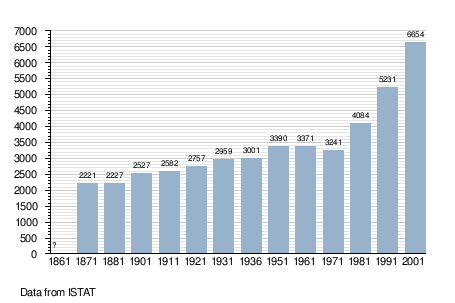
Demographic evolution
References
External links
| Wikimedia Commons has media related to Fabrica di Roma. |
 Fabrica di Roma travel guide from Wikivoyage
This article is issued from Wikipedia - version of the 1/5/2016. The text is available under the Creative Commons Attribution/Share Alike but additional terms may apply for the media files.