Falkirk Steeple
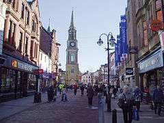
The Falkirk Steeple is a landmark which dominates the skyline of Falkirk in central Scotland. The present structure on the High Street was built in 1814, and replaced an earlier steeple dating from the late 17th century, which itself replaced a still earlier structure. The Falkirk Steeple is protected as a category A listed building.[1] A stylised image of the steeple appears on the crest of Falkirk Football Club.
History
The present steeple dates from 1814, and was designed by the architect David Hamilton in a classical style. It is 43 metres (141 ft) high, with cells on the upper floors and a clock in the third of the four stages of the building.[1]
The steeple was damaged in 1927 when it was struck by lightning, causing the spire to be destroyed. So harsh was the lightning strike, parts of the roof were found scattered several metres away. One casualty from the incident was "Carnaver", a Barr's delivery horse. The upper 9 metres (30 ft) of the steeple was rebuilt. A family living in property adjacent to the steeple had a miraculous escape. The masonry crashed through the roof of their house trapping them. Mrs Isabella Barr, age 21, her sons James age 2 and Andrew age 1, were buried in the rubble. Newspapers at the time described that the "clothes had been torn from their bodies". Mrs Barr also suffered a broken leg and deep lacerations. The verification of these injuries is given by Mrs Barr's youngest son, Stephen on 6th Sept 2012.
The steeple contains a prison cell which was still in use until 1984.[2]
Old steeple
The previous steeple, which stood on the same site, was constructed in 1697 and served as the town's tolbooth and temporary gaol until the late 18th century.[3] This was demolished after construction of an adjacent building in 1803 caused the steeple to subside.[1] Little is known of the earliest steeple, though its demolition in 1697 is recorded.
References
- 1 2 3 "Falkirk Town Steeple". Historic Scotland.
- ↑ Mair, Craig (1988). Mercat Cross and Tolbooth: Understanding Scotland's Old Burghs. Edinburgh: John Donald. p. 48. ISBN 0-85976-196-7.
- ↑ "Falkirk, High Street, Town Steeple". CANMORE. Royal Commission on the Ancient and Historical Monuments of Scotland.
External links
- Falkirk Steeple Box Office, Falkirk Community Trust
- Walk 2, Falkirk Town Centre 2, Falkirk Local History Society
Coordinates: 55°59′56″N 3°47′06″W / 55.999°N 3.785°W