Fedje (village)
| Fedje | |
|---|---|
| Village | |
|
View of the village | |
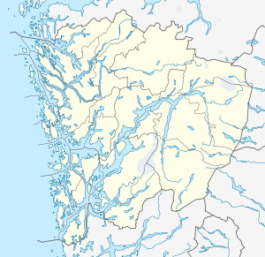 Fedje  Fedje Location in Hordaland county | |
| Coordinates: 60°46′44″N 04°42′53″E / 60.77889°N 4.71472°ECoordinates: 60°46′44″N 04°42′53″E / 60.77889°N 4.71472°E | |
| Country | Norway |
| Region | Western Norway |
| County | Hordaland |
| District | Nordhordland |
| Municipality | Fedje |
| Area[1] | |
| • Total | 0.68 km2 (0.26 sq mi) |
| Elevation[2] | 14 m (46 ft) |
| Population (2013)[1] | |
| • Total | 429 |
| • Density | 631/km2 (1,630/sq mi) |
| Time zone | CET (UTC+01:00) |
| • Summer (DST) | CEST (UTC+02:00) |
| Post Code | 5947 Fedje |
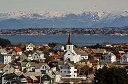
Fedje is the administrative centre of Fedje municipality in Hordaland county, Norway. The village is located on the northern shores of the island of Fedje.[3] The fishing village is an old trading center, which grew up around Kræmmerholmen, a small island in the Fedje harbor. The 0.68-square-kilometre (170-acre) village has a population (2013) of 429, giving the village a population density of 631 inhabitants per square kilometre (1,630/sq mi).[1] Fedje Church is located in the village, serving the people of the whole municipality.
References
- 1 2 3 Statistisk sentralbyrå (1 January 2013). "Urban settlements. Population and area, by municipality.".
- ↑ "Fedje, Fedje" (in Norwegian). yr.no. Retrieved 2014-04-07.
- ↑ Store norske leksikon. "Fedje – tettstedet" (in Norwegian). Retrieved 2014-04-07.
This article is issued from Wikipedia - version of the 8/4/2016. The text is available under the Creative Commons Attribution/Share Alike but additional terms may apply for the media files.