Felsennest
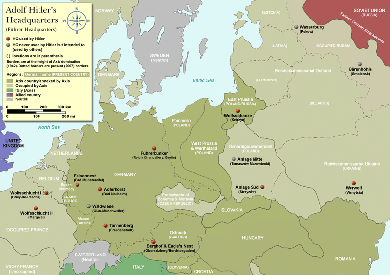
Map showing the location of "Felsennest", and other Führer Headquarters throughout Europe.
At the start of the Western European campaign of 1940, the Felsennest ("Rocky Eyrie" in English) was the codename for one of Hitler's Führer Headquarters near Bad Münstereifel, Germany. It was much more cramped than Adolf Hitler's other field bunkers, having only four rooms. Hitler was at the Felsennest in the autumn of 1939, because there were plans to invade France and the Low Countries. He was there again on May 10, 1940 when the invasion took place.
Literature
- Groß, Manfred: Bunkerstellungen der Luftverteidigungszone West im Rheinland und Hitlers Hauptquartier in Bad Münstereifel-Rodert. Verlag Werner Sünkel (Leinburg), Offenhausen 2001 (S. 67–106). ISBN 3-930060-90-6.
- Hansen, Hans-Josef: Felsennest – Das vergessene Führerhauptquartier in der Eifel. Bau, Nutzung, Zerstörung. Helios, Aachen 2008, 2. erweiterte Neuauflage (umfangreiche Dokumentation über das erste ortsfeste Führerhauptquartier des Zweiten Weltkrieges mit zahlreichen historischen und aktuellen Aufnahmen sowie Zeitzeugenberichten). ISBN 3-938208-21-X.
- Kuffner, Alexander: Zeitreiseführer Eifel 1933–1945. Taschenbuch. Seite 32–38. Helios, Aachen 2007, ISBN 978-3-938208-42-7.
- Raiber, Richard: The Führerhauptquartier – Guide to Hitler´s Headquarters (After the Battle, Nr. 19), London 1977.
- TV-Dokumentation: Hitlers Führerhauptquartiere von Rudolf Sporrer. Bayerischer Rundfunk 2003.
See also
Coordinates: 50°32′45″N 6°46′10″E / 50.54583°N 6.76944°E
This article is issued from Wikipedia - version of the 8/13/2016. The text is available under the Creative Commons Attribution/Share Alike but additional terms may apply for the media files.