Feugères
| Feugères | |
|---|---|
|
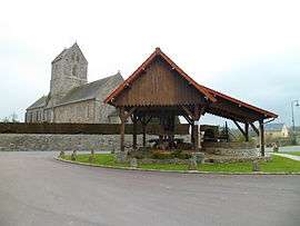
The Wine Press and the church of Saint-Pierre | |
 Feugères | |
|
Location within Normandy region  Feugères | |
| Coordinates: 49°09′06″N 1°19′09″W / 49.1517°N 1.3192°WCoordinates: 49°09′06″N 1°19′09″W / 49.1517°N 1.3192°W | |
| Country | France |
| Region | Normandy |
| Department | Manche |
| Arrondissement | Coutances |
| Canton | Périers |
| Intercommunality | Communauté de communes de Sèves et Taute |
| Government | |
| • Mayor (2008–2014) | Jacques Vantomme |
| Area1 | 8.31 km2 (3.21 sq mi) |
| Population (2006)2 | 344 |
| • Density | 41/km2 (110/sq mi) |
| Time zone | CET (UTC+1) |
| • Summer (DST) | CEST (UTC+2) |
| INSEE/Postal code | 50181 / 50190 |
| Elevation |
4–112 m (13–367 ft) (avg. 13 m or 43 ft) |
|
1 French Land Register data, which excludes lakes, ponds, glaciers > 1 km² (0.386 sq mi or 247 acres) and river estuaries. 2 Population without double counting: residents of multiple communes (e.g., students and military personnel) only counted once. | |
Feugères is a commune in the Manche department in north-western France.
See also
| Wikimedia Commons has media related to Feugères. |
This article is issued from Wikipedia - version of the 3/5/2015. The text is available under the Creative Commons Attribution/Share Alike but additional terms may apply for the media files.