Fifteenmile Creek (Columbia River)
| Fifteenmile Creek | |
 Looking upstream from the North Main Street bridge in Dufur | |
| Country | United States |
|---|---|
| State | Oregon |
| Counties | Hood River and Wasco |
| Source | Lookout Mountain |
| - location | east of Mount Hood, Hood River County, Oregon |
| - elevation | 6,178 ft (1,883 m) [1] |
| - coordinates | 45°20′35″N 121°31′18″W / 45.34306°N 121.52167°W [2] |
| Mouth | Columbia River |
| - location | near The Dalles, Wasco County, Oregon |
| - elevation | 95 ft (29 m) [2] |
| - coordinates | 45°36′50″N 121°07′22″W / 45.61389°N 121.12278°WCoordinates: 45°36′50″N 121°07′22″W / 45.61389°N 121.12278°W [2] |
| Length | 54 mi (87 km) [3] |
| Basin | 373 sq mi (966 km2) [4] |
 Location of the mouth of Fifteenmile Creek in Oregon | |
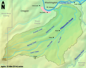 The Fifteenmile Creek watershed | |
Fifteenmile Creek is a 54-mile (87 km) long[3] tributary of the Columbia River, located in the U.S. state of Oregon. It drains 373 square miles (966 km2) of Hood River and Wasco counties. Arising in the Cascade Range near Mount Hood, it flows northeast, then west to its confluence with the Columbia near The Dalles.
It was named "fifteenmile" because in pioneer days the main road crossed the creek about fifteen miles (24 km) from The Dalles.[5]
Course
Fifteenmile Creek's headwaters are located near Lookout Mountain in the Cascade Range, east of Mount Hood. It flows northeast, crossing into Wasco County and gathering small tributaries such as Ramsey Creek and Pine Creek. Traveling through the city of Dufur, the creek is crossed by Highway 197. Fifteenmile Creek receives Dry Creek on the right downstream of Dufur, turning north. It then flows west, receiving Eightmile Creek on the left while paralleling the Columbia River. The creek is crossed by Interstate 84/Highway 30 just before its mouth. It flows into the Columbia approximately 191 miles (307 km) above its confluence with the Pacific Ocean.[6]
Watershed
Fifteenmile Creek drains 373 square miles (966 km2) of the Columbia Plateau region of Oregon.[4] Fifteen percent of the watershed is located in Mount Hood National Forest and therefore owned by the United States Forest Service, while the remaining eighty-five percent is privately owned.[4][7] Elevations in the watershed range from 6,525 feet (1,989 m) at the summit of Lookout Mountain to 95 feet (29 m) at the creek's mouth.[2][7]
Fish
Several species of anadromous fish inhabit streams in the watershed, including steelhead, Pacific lamprey, chinook and coho salmon.[4][7] Fifteenmile Creek is the easternmost tributary of the Columbia home to winter steelhead.[7] Fish Fifteenmile Creek coho salmon populations are within the Lower Columbia River Coho Evolutionary Significant Unit and are listed as a threatened (2011).[8] Populations have declined in recent years, due to a combination of overfishing, an increase of hydroelectric dams, and general worsening of habitat conditions.[4]
See also
References
- ↑ Source elevation derived from Google Earth search using GNIS source coordinates.
- 1 2 3 4 "Fifteenmile Creek". Geographic Names Information System. United States Geological Survey. November 28, 1980. Retrieved September 14, 2010.
- 1 2 "National Hydrography Dataset". United States Geological Survey. Archived from the original on 2012-11-01. Retrieved September 14, 2010.
- 1 2 3 4 5 Mount Hood National Forest (May 2010). "Fifteenmile Creek Basin Aquatic Habitat Restoration Strategy" (PDF). United States Forest Service. Retrieved September 14, 2010.
- ↑ McArthur, Lewis A.; McArthur, Lewis L. (1992) [1928]. Oregon Geographic Names (6th ed.). Portland, Oregon: Oregon Historical Society Press. p. 310. ISBN 978-0875952369.
- ↑ Oregon Road and Recreation Atlas (Map) (4th ed.). 1:225,000. Benchmark Maps. 2010. pp. 38–39. ISBN 978-0-929591-62-9. OCLC 466904230.
- 1 2 3 4 Mount Hood National Forest (March 7, 2003). "Fifteenmile Watershed Assessment" (PDF). Wasco County Soil and Water Conservation District. Retrieved September 14, 2010.
- ↑ "5-Year Review: Summary & Evaluation of Lower Columbia River Chinook, Columbia River Chum, Lower Columbia River Coho, Lower Columbia River Steelhead" (PDF). National Oceanic and Atmospheric Administration. 2011. Retrieved 2013-12-03.