Filefjell Kongevegen
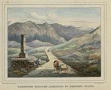
The Filefjell Kongevegen (English: The Kings Road) is the name of the old trail over Filefjell, the mountainous area between Lærdal/Borgund and Valdres in Norway. It is the historical main route linking Western Norway and Eastern Norway.
Due to the sometimes wet and marshy land in the valley bottom, the old trail runs farther up in the hill than the modern asphalt road does today. The old trail is still used for hiking. It was named after King Sverre of Norway (1184–1202) who traveled this route with his army. The first post route came this way in 1647. The road got official status as a main road in the year 1791.[1][2]
Maristova in Filefjell (built at Queen Margaret's command around 1390) and Nystuen in Vang (first mentioned in 1627 but believed to be much older) are guest houses that provided for travelers along the road. The owners were compensated by the king and commanded to aid travelers and provide shelter for those who used the road. This practice lasted until 1830.
Today, Kongevegen has been restored, opening it up for hikers. Major sections such as Vindhella provide an insight into the skills in use by the road engineers of the time.
References
- ↑ "Filefjell - hovedvegen aust-vest" (in Norwegian). Norwegian Broadcasting Corporation. 1 May 2004. Retrieved 2009-02-21.
- ↑ "E-16 Øye-Filefjell" (in Norwegian). Norwegian Public Roads Administration. 30 May 2008. Retrieved 2009-02-21.
Coordinates: 61°09′07″N 8°00′20″E / 61.1520°N 8.0055°E