Fladen Ground
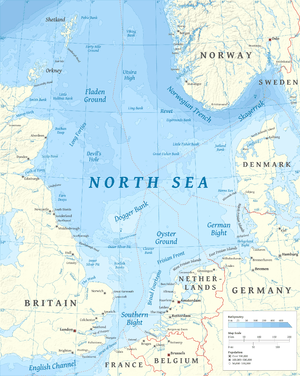
Fladen Ground is an area in the Scottish sector of the North Sea, between Scotland and Norway, about 100 miles (160 km) northeast of Aberdeen.[1] The Fair Isle current and East Shetland Islands Atlantic inflow form an eddy, creating a weak, anti-clockwise rotating vortex that is evidenced in the surface form of the seabed.[1][2] Due to stratification of the water column in the summer months, seasonal variation of the temperature in deep water is low (5.7–8 °C, 42–46 °F).[1] Average water depth is in the range of 100–150 metres (330–490 ft; 55–82 fathoms), and the mostly muddy sea floor has been created by incoming sediments from the surrounding sea areas.[1][3] The dominant benthic animals are polychaetes and shellfish and other seafoods are common.[1]
Fladen Ground is rich in oil and natural gas and offers good fishing.[4][5] Scottish vessels catch low-fat fish species, and Norway lobster. Danish and English vessels catch Northern prawn.[6]
See also
Dogger Bank for links to similar places
Notes
- 1 2 3 4 5 Witbaard, Rob (1996). "Growth Variations in Arctica Islanda L. (Mollusca): a reflection of hydrography-related food supply" (PDF). ICES Journal of Marine Science. doi:10.1006/jmsc.1996.0122.
- ↑ Athena Field Development, p 61
- ↑ Athena Field Development, p 60
- ↑ Athena Field Development, p 7
- ↑ Athena Field Development, p 68
- ↑ Athena Field Development, p 84
References
- "Environmental Statement: Athena Field Development - Block 14/18b" (pdf). Ithaca Energy (UK) Ltd. August 2008.
Coordinates: 58°30′00″N 0°30′00″E / 58.5000°N 0.5000°E