Flims Rockslide
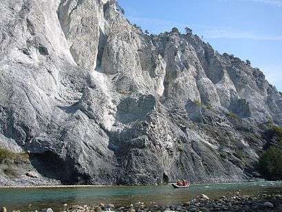
The Flims Rockslide occurred about 10,000 years ago in what is now eastern Switzerland. It is known as the biggest landslide incident in the Alps and the biggest worldwide whose effects are still visible, moving some 12 km3 (2.9 cu mi) of rock, about 300 times that of the historic Swiss Goldau landslide. The town of Flims can be found at the line where the slip surface disappears under the debris. North of Flims the rock face of Flimserstein stands 350 metres (1,148 ft) high whereas more westerly the slide surface is clearly visible. South of Flims lies a huge hilly debris area that ever remained a forest as this area is not suitable for farming firstly for its shape and even more for its lack of water. The river Rhine crosses this debris in a gorge called Ruinaulta. The Rhine nowadays is still running in debris which means it has not yet reached its level before the incident. The highest hill in the debris area is almost 200 metres (656 ft) higher than Flims at the end of the sliding surface.
Landscape


The top of the slide surface can be found at 2,700 metres (8,858 ft) above sea north of Flims at Fil de Cassons whereas the end of the slide surface lies at about 1100. The covered valley would have been at 600 metres (1,969 ft). The rock is limestone dating from the Mesozoic, including Mergel, the angle of slide is (only) 20° to 25°. Debris covers an area of 40 km2 (15 sq mi). Pressure baked the debris together to a somewhat stable rock. Given the river Rhine as a base of the valley the debris is as high as 600 metres (1,969 ft). This debris built a dam for Vorderrhein and created a lake in the Ilanz area. The level of the lake was found to have been at a maximum of 840 metres (2,756 ft) above sea level which results in a length of the lake of some 10 miles (16 km).[1]
Dating
Clemens Augenstein from Geologisches Institut der ETH Zürich explored with Professor Flavio Anselmetti the sediments at a small lake called Dachlisee at 1,137 metres (3,730 ft) near Obersaxen. The lake with no river flowing into it lies opposite Flims, some 6 miles (9.7 km) away. They were looking for dust as an incident of this size would have produced a giant dust cloud. Drilling five times into the sediment they found embedded limestone dust. Using carbon dating the limestone dust was found to be 10055 years old (plus/minus 195 years).
A second source is wood, that was found inside the debris in the region, some 2 miles (3.2 km) upstream of the mouth of river Rabiusa, which was covered by massive rock identified from the Fil de Cassons area, hence reaching this point at the event; too old for the Dendrochronology line but confirming the above carbon dating.[2]
Flow System

After the slide most of the water escaped through the upper section of the debris. There are several examples of rivers disappearing in the alps and also in Scotland. The lakes in the debris area still behave in this way such as Caumasee. The Ilanz lake existed some 1000 to 2000 years before the water cut through the debris, creating the Gorge.
Sightseeing

- The place Dutjen above Valendas is opposite and gives a good overview.
- The aerial cableway from Flims onto Cassonsgrat takes you to the tear-off edge of the landslide. There is various hikes to this ridge as well. One route uses the ascent via Val Bargis, probably the nicest ascent although you can not actually see the rockslide area before reaching the top.[3]
- The railway line of the Rhätische Bahn crosses Ruinaulta close to river Rhine. Except for access to the railway stations there is no roads into this area and no parking. A footpath goes for two thirds of the gorge, the last bit is being built in 2010/2011. Connections lead out of the gorge.
- In Conn on the actual debris there is a viewing platform in the shape of a common swift, overlooking Ruinaulta. Walking there you will encounter a little artificial stream that ancient farmers built to get water to some fields in the area as there is no natural surface water.
- There is river rafting on the Rhine.
References
- ↑ A.v.Poschinger, Angewandte Geologie, Vol. 11/2, 2006 english version
- ↑ A.v.Poschinger, Angewandte Geologie, Vol. 11/2, German version including carbon dating of wood in debris
- ↑ Hiking Switzerland Graubünden Fil de Cassons
Notes
- Albert Heim: Der alte Bergsturz von Flims 18. Jahrbuch des Schweizer Alpenklub 1882-1883 p. 295-309
- [BERGSTURZ-GEBIETE DER SCHWEIZ, PROFILE] [Kartenmaterial] / Alb.Heim. - Zürich: Kunstanstalt J.C.Müller, Abt.Kartogr.Hofer, 191.. [000450082]
- G. Hartung: Das alte Bergsturzgebiet von Flims, Zeitschrift der Gesellschaft für Erdkunde. Berlin (19) 1884
- Dr. Julius Weber: Klubführer; Geologische Wanderungen durch die Schweiz (II), 1913 S. 162-173
- Seesedimente auf der Flimser Bergsturzmasse: ein neuer Ansatz zur Datierung der grössten Massenbewegung der Alpen (~ 9490 - 9460 cal. y BP): Flims/Laax, Graubünden, Schweiz / Gaudenz Deplazes. Zürich; 2005.. 140 S.: Ill. + 4 Falttaf.. [005083370]
- Emil Kirchen: Wenn der Berg stürzt: das Bergsturzbegiet zwischen Chur und Ilanz - Chur [etc.]: Terra Grischuna, cop. 1993. [000943845] ISBN 3-7298-1087-1
- Zur Hydrogeologie des Bergsturzgebietes im Raum Flims / Y. P. Bonanomi.. . [et al.]. - Bern: Landeshydrologie und -geologie, cop. 1994. (Geologische Berichte / Landeshydrologie und -geologie; Nr. 17) [000955866]
- Carl Bieler: Als der Berg runterkam, 2006, Migros-Magazin
External links
- dead link] A.v.Poschinger, Angewandte Geologie, Vol. 10/1, 2005 (PDF-Datei; 1,13 MB)
- S. Plahuta; Review 1999
- Naturmonument Ruinaulta
| Wikimedia Commons has media related to Flims Rockslide. |