Flinders River
| Flinders | |
| River | |
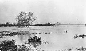 Flooding of the Flinders River at Hughenden, January 1917 | |
| Name origin: In honour of Matthew Flinders | |
| Country | Australia |
|---|---|
| State | Queensland |
| Region | North West Queensland, Gulf Country |
| Tributaries | |
| - left | Cloncurry River, Corella River, Bynoe River |
| - right | Saxby River |
| Settlements | McKinlay, Hughenden, Richmond, Julia Creek, Cloncurry, Burke and Wills Junction |
| Source | Burra Range, Great Dividing Range |
| - location | Reedy Springs |
| - elevation | 816 m (2,677 ft) |
| Mouth | Gulf of Carpentaria |
| - location | west of Karumba |
| - elevation | 0 m (0 ft) |
| - coordinates | 17°35′59″S 140°35′44″E / 17.59972°S 140.59556°ECoordinates: 17°35′59″S 140°35′44″E / 17.59972°S 140.59556°E |
| Length | 1,004 km (624 mi) |
| Basin | 109,000 km2 (42,085 sq mi) |
| Discharge | |
| - average | 122 m3/s (4,308 cu ft/s) |
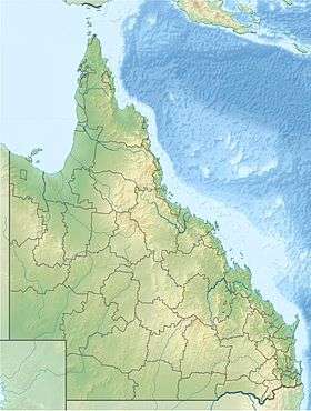 Location of Flinders River mouth in Queensland | |
| Wikimedia Commons: Flinders River | |
| [1] | |
The Flinders River is the longest river in Queensland, Australia at approximately 1,004 kilometres (624 mi).[2] It was named in honour of the explorer Matthew Flinders. The catchment is sparsely populated and mostly undeveloped. The Flinders rises on the western slopes of the Great Dividing Range in North West Queensland and flows generally northwest across a large, flat claypain through the Gulf Country before entering the Gulf of Carpentaria.
Course and features
The river rises in the Burra Range, part of the Great Dividing Range,[3] 110 kilometres (68 mi) northeast of Hughenden and flows in a westerly direction past Hughenden, Richmond and Julia Creek then northwest to the Gulf of Carpentaria 25 km (16 mi) west of Karumba. The south of the catchment is bordered by the Selwyn Range. At 1,004 kilometres (624 mi) in length it is the eighth longest river in Australia.[2] The catchment covers 109,000 square kilometres (42,000 sq mi).[4] The primary land use in the catchment is grazing[5] and other agriculture, the catchment covers 1.5% of the continent.[6]
A total of 36 tributaries flow into the Flinders,[1] the principal tributaries are the Cloncurry, Saxby and the Corella rivers.[4] Another major tributary of the Flinders River is Porcupine Creek. The creek has carved out a dramatic gorge which is located in the Porcupine Gorge National Park.[7] There are two dams on the river - the Flinders River Dam and Corella Dam.[5] Other smaller tributaries include; Range Creek, Morepork Creek, Oxley Creek, Canterbury Creek, Dutton River, Back Valley Creek, L-Tree Creek, Gorman Creek, Hazlewood Creek, Nonda Creek, Eurimpy Creek, Yambore Creek, Bynoe River and Armstrong Creek. The river flows through one permanent waterhole; Flagstone waterhole.[1]
Several towns are found within the catchment including; McKinlay, Burke and Wills Junction, Hughenden, Richmond, Julia Creek and Cloncurry.[3]
The river produces a mean annual discharge of 3,857 gigalitres (8.48×10¹¹ imp gal; 1.019×10¹² US gal).[3] The maximum flow recorded is 18,000 gigalitres (4.0×10¹² imp gal; 4.8×10¹² US gal).[8]
The riverbed is composed of silt with clay and sand, sand and gravel and gravel with cobble.[8] A large, flat claypain is located in the area where the Flinders, Gregory and Leichhardt Rivers enter the Gulf. The mouth of the river lies in the Gulf Plains Important Bird Area.[9]
In 2015 the population living within the catchment was 6,600 people of which 12% are indigenous.[10]
Flora
Vegetation along the river in the upper catchment include riparian woodlands composed of paperbarks including; Melaleuca argentea, Melaleuca bracteata and Melaleuca fluviatilis and sub-dominant eucalypts including River Red Gum, Coolabah, with minor Bauhinia. Other species found include the wattle. Infestations of Weeds such as Prickly acacia, Noogoora burr, Rubber vine and Chonky apple are also found.[11] The understorey is dominated by a closed cover of riparian grasses including native couch on the sandy loams adjacent the stream channels.
History
The traditional owners of the area are the Kalkadoon, Mitakoodi, Kukatj, Guthaarn, Mayi-Yapi, Mayi-Kulan, Mayi-Thakurti, Ngawun, Wanamara, Mbara, Yirandali and Gugu-Badhun peoples who have inhabited the area for thousands of years.[3]
The Flinders River was named in honour of the explorer Matthew Flinders by Captain Wickham and Lieutenant John Lort Stokes of the HMS Beagle in 1841. Stokes chartered and surveyed the estuary of the Flinders and albert rivers and named many other features in the area including Disaster Inlet, Morning Inlet and Van Deiman River.[12]
Robert O'Hara Burke, William John Wills and Charles Gray reached the river delta in 1861 completing the goal of their expedition. Gray died on the journey back to Cooper Creek and both Burke and Wills died after reaching the creek to find their depot abandoned.[12]
The first pastoralist to stock country along the Flinders was James Gibson who established Prairie Station in 1861. In 1864 more cattle stations were established by Gibson including Millungera and Taldora Stations.[12]
Massive flooding occurred along the river in July 1870. One station lost over 4,000 sheep and roads were cut. In 1917 even larger floods were recorded with Hughenden inundated several people drowned. More heavy flooding occurred in 1955, 1960, 1974, 1991 and 2000.[13]
In 2003, water licences to take water from the river were fist released when a pastoralist, Corbett Tritton, applied for an irrigation licence. He successfully grew crops like sorghum and cotton on his cattle station and soon other graziers were interested. A moratorium on licence issuing followed but was later lifted in 2013.[6]
See also
References
- 1 2 3 "Map of Flinders River, QLD". Bonzle Digital Atlas of Australia. 2015. Retrieved 30 May 2015.
- 1 2 "Longest Rivers". Geoscience Australia. Commonwealth of Australia. 18 November 2010. Retrieved 3 July 2011.
- 1 2 3 4 "The Land - Overview". Southern Gulf Catchments. Retrieved 30 May 2015.
- 1 2 "Flood Warning System For The Flinders River". Bureau of Meteorology. Retrieved 3 July 2011.
- 1 2 "Water resources - Overview - Queensland: Flinders River". Australian Natural Resources Atlas. Department of Sustainability, Environment, Water, Population and Communities. Retrieved 3 July 2011.
- 1 2 "From cattle country to crops: Flinders River moratorium lifted". Australian Broadcasting Corporation. 18 February 2013. Retrieved 30 May 2015.
- ↑ Shilton, Peter (2005). Natural Areas of Queensland. Mount Gravatt, Queensland: Goldpress. p. 256. ISBN 0-9758275-0-2.
- 1 2 Alisha Steward; et al. "Terrestrial invertebrates of dry river beds are not simply subsets of riparian assemblages" (PDF). Griffith University. Retrieved 31 May 2015.
- ↑ BirdLife International (2011) Important Bird Areas factsheet: Gulf Plains. Downloaded from http://www.birdlife.org on 01/07/2011
- ↑ "Flinders River catchment". TRaCK. Retrieved 30 May 2015.
- ↑ Tait, Jim (July 1998). "Richmond Dam and irrigation development proposal ecological issues" (PDF). James Cook University. Retrieved 31 May 2015.
- 1 2 3 Palmer, Edward (1903). "Early Days in North Queensland". Project Gutenberg.
- ↑ "Archive: Harden Up Chronological History of Flooding 1857-2010" (PDF). Green Cross Australia. Retrieved 30 May 2015.
External links
![]() Media related to Flinders River at Wikimedia Commons
Media related to Flinders River at Wikimedia Commons
Rivers of Queensland | |||||||||||||||||||||||||
|---|---|---|---|---|---|---|---|---|---|---|---|---|---|---|---|---|---|---|---|---|---|---|---|---|---|
| |||||||||||||||||||||||||
| |||||||||||||||||||||||||
| |||||||||||||||||||||||||
| |||||||||||||||||||||||||
| |||||||||||||||||||||||||
| |||||||||||||||||||||||||