Flowerdale, Alberta
| Flowerdale | |
|---|---|
| Unincorporated community | |
|
Remains of Flowerdale, Alberta | |
 Location of Flowerdale in Alberta | |
| Coordinates: 51°21′58″N 111°33′54″W / 51.366°N 111.565°W | |
| Country |
|
| Province |
|
| Census division | No. 4 |
| Special Area | No. 2 |
| Government | |
| • Type | Unincorporated |
| • Governing body | Special Areas Board |
| Time zone | MST (UTC-7) |
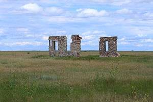
Flowerdale is a former locality in southern Alberta, Canada within Special Area No. 2. It is located approximately 24 kilometres (15 mi) southwest of the Village of Youngstown and 113 kilometres (70 mi) north of the City of Brooks. The settlement consisted of a post office, general store, and a sod house.[1][2] Flowerdale has since been left uninhabited.[3]
See also
References
- ↑ "Sunnynook District - Hanna Alberta". hanna.ca. Retrieved 2015-01-12.
- ↑ "Sod house and store at Flowerdale, Alberta. - Canadiana Discovery Portal". search.canadiana.ca. Retrieved 2015-01-12.
- ↑ Echoes From This, Our Land - Local history book
External links
- Roads to Rose Lynn - History book
- Place Names: Alberta GenWeb - Flowerdale; 1-28-12-w4; Special Area 2; Former Locality
- A. R. Stewart's stone house at Flowerdale, Alberta.
- We'll all be Buried Down Here : the Prairie Dryland Disaster, 1917-1926 - Our Roots
This article is issued from Wikipedia - version of the 8/6/2015. The text is available under the Creative Commons Attribution/Share Alike but additional terms may apply for the media files.