Fontcouverte-la-Toussuire
| Fontcouverte-la-Toussuire | ||
|---|---|---|
|
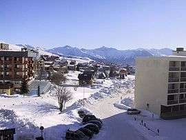
The ski station of La Toussuire | ||
| ||
 Fontcouverte-la-Toussuire | ||
|
Location within Auvergne-Rhône-Alpes region  Fontcouverte-la-Toussuire | ||
| Coordinates: 45°14′50″N 6°18′11″E / 45.2472°N 6.3031°ECoordinates: 45°14′50″N 6°18′11″E / 45.2472°N 6.3031°E | ||
| Country | France | |
| Region | Auvergne-Rhône-Alpes | |
| Department | Savoie | |
| Arrondissement | Saint-Jean-de-Maurienne | |
| Canton | Saint-Jean-de-Maurienne | |
| Intercommunality | Arvan | |
| Government | ||
| • Mayor (2008–2014) | Bernard Anselme | |
| Area1 | 21.52 km2 (8.31 sq mi) | |
| Population (2006)2 | 563 | |
| • Density | 26/km2 (68/sq mi) | |
| Time zone | CET (UTC+1) | |
| • Summer (DST) | CEST (UTC+2) | |
| INSEE/Postal code | 73116 / 73300 | |
| Elevation | 659–2,305 m (2,162–7,562 ft) | |
| Website | La-toussuire.com | |
|
1 French Land Register data, which excludes lakes, ponds, glaciers > 1 km² (0.386 sq mi or 247 acres) and river estuaries. 2 Population without double counting: residents of multiple communes (e.g., students and military personnel) only counted once. | ||
.svg.png)
This article is about the commune in Savoie. For the climb used in cycle racing, see La Toussuire.
Fontcouverte-la-Toussuire is a commune in the Savoie department in the Auvergne-Rhône-Alpes region in south-eastern France.
See also
References
External links
| Wikimedia Commons has media related to Fontcouverte-la-Toussuire. |
This article is issued from Wikipedia - version of the 10/28/2016. The text is available under the Creative Commons Attribution/Share Alike but additional terms may apply for the media files.