Forest Park Southeast Historic District
|
Forest Park Southeast Historic District | |
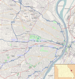   | |
| Location | Roughly bounded by Chouteau Ave., Manchester and Cadet Aves., Kingshighway Blvd., and S. Sarah St., St. Louis, Missouri (original); 4170-4370 (even) and 4229-4341 (odd) Manchester Ave. (boundary increase 2005); 4121-25, 4127-29, 4131, 4133, 4137, 4139-41, 4143, 4145, 4501-07, 4509-11, 4510, and 4512-14 Manchester Ave. (boundary increase 2007) |
|---|---|
| Coordinates | 38°37′43″N 90°15′33″W / 38.62861°N 90.25917°WCoordinates: 38°37′43″N 90°15′33″W / 38.62861°N 90.25917°W |
| Architect | Arnold, Frank; et al. |
| Architectural style | Colonial Revival, Romanesque, et al. |
| NRHP Reference # |
01001360 (original), 05000612 (boundary increase 2005), 07000015 (boundary increase 2007) [1] |
| Added to NRHP | December 20, 2001 |
Forest Park Southeast Historic District is a historic district roughly bounded by Chouteau Ave., Manchester and Cadet Aves., Kingshighway Blvd., and S. Sarah St. in St. Louis, Missouri. It was added to the National Register of Historic Places in 2001. Architecture in the district includes Colonial Revival and Romanesque styles. Buildings in the district include single and multiple dwellings, a specialty store, a religious structure and a meeting hall. A boundary increase added 4170-4370 (even) and 4229-4341 (odd) Manchester Ave. to the district in 2005. A second boundary increase added 4121-25, 4127-29, 4131, 4133, 4137, 4139-41, 4143, 4145, 4501-07, 4509-11, 4510, and 4512-14 Manchester Ave. in 2007.[1]
References
- 1 2 National Park Service (2009-03-13). "National Register Information System". National Register of Historic Places. National Park Service.
| Topics | |
|---|---|
| Lists by states |
|
| Lists by insular areas | |
| Lists by associated states | |
| Other areas | |
| |