Fort Ripley, Minnesota
| Fort Ripley, Minnesota | |
|---|---|
| City | |
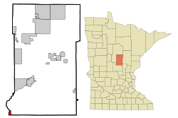 Location of the city of Fort Ripley within Crow Wing County, Minnesota | |
| Coordinates: 46°10′N 94°22′W / 46.167°N 94.367°W | |
| Country | United States |
| State | Minnesota |
| County | Crow Wing |
| Area[1] | |
| • Total | 1.44 sq mi (3.73 km2) |
| • Land | 1.32 sq mi (3.42 km2) |
| • Water | 0.12 sq mi (0.31 km2) |
| Elevation | 1,168 ft (356 m) |
| Population (2010)[2] | |
| • Total | 69 |
| • Estimate (2012[3]) | 69 |
| • Density | 52.3/sq mi (20.2/km2) |
| Time zone | Central (CST) (UTC-6) |
| • Summer (DST) | CDT (UTC-5) |
| ZIP code | 56449 |
| Area code(s) | 218 |
| FIPS code | 27-21932[4] |
| GNIS feature ID | 0643824[5] |
Fort Ripley is a city in Crow Wing County, Minnesota, United States, near the confluence of the Mississippi and Nokasippi Rivers. The population was 69 at the 2010 census.[6] It is part of the Brainerd Micropolitan Statistical Area.
History
Fort Ripley was a United States military installation beginning in 1849 and lasting until 1877.[7] The fort, now Camp Ripley, was located on the opposite side of the Mississippi River from Morrison County as the current city in Crow Wing County.
The city of Fort Ripley was incorporated in 1927.[8] The city took its name from the fort, and that was named for Eleazer Wheelock Ripley, an American soldier and politician.[9]
Geography
According to the United States Census Bureau, the city has a total area of 1.44 square miles (3.73 km2), of which 1.32 square miles (3.42 km2) is land and 0.12 square miles (0.31 km2) is water.[1]
The city of Fort Ripley is located between Little Falls and Brainerd along Minnesota State Highway 371 near Over the Hill Road and Crow Wing County Road 2. The Mississippi River, the Nokasippi River, and the Little Nokasippi River are all in the vicinity.
The boundary line between Crow Wing and Morrison counties is nearby.
Demographics
| Historical population | |||
|---|---|---|---|
| Census | Pop. | %± | |
| 1930 | 105 | — | |
| 1940 | 126 | 20.0% | |
| 1950 | 88 | −30.2% | |
| 1960 | 55 | −37.5% | |
| 1970 | 54 | −1.8% | |
| 1980 | 83 | 53.7% | |
| 1990 | 92 | 10.8% | |
| 2000 | 74 | −19.6% | |
| 2010 | 69 | −6.8% | |
| Est. 2015 | 69 | [10] | 0.0% |
| U.S. Decennial Census | |||
2010 census
As of the census[2] of 2010, there were 69 people, 33 households, and 20 families residing in the city. The population density was 52.3 inhabitants per square mile (20.2/km2). There were 37 housing units at an average density of 28.0 per square mile (10.8/km2). The racial makeup of the city was 97.1% White, 1.4% Native American, and 1.4% Asian.
There were 33 households of which 21.2% had children under the age of 18 living with them, 54.5% were married couples living together, 3.0% had a female householder with no husband present, 3.0% had a male householder with no wife present, and 39.4% were non-families. 33.3% of all households were made up of individuals and 9.1% had someone living alone who was 65 years of age or older. The average household size was 2.09 and the average family size was 2.70.
The median age in the city was 50.5 years. 17.4% of residents were under the age of 18; 0.0% were between the ages of 18 and 24; 26% were from 25 to 44; 39.1% were from 45 to 64; and 17.4% were 65 years of age or older. The gender makeup of the city was 53.6% male and 46.4% female.
2000 census
As of the census[4] of 2000, there were 74 people, 34 households, and 24 families residing in the city. The population density was 55.6 people per square mile (21.5/km²). There were 35 housing units at an average density of 26.3 per square mile (10.2/km²). The racial makeup of the city was 94.59% White, 1.35% Native American, 1.35% from other races, and 2.70% from two or more races. Hispanic or Latino of any race were 4.05% of the population.
There were 34 households out of which 11.8% had children under the age of 18 living with them, 61.8% were married couples living together, 2.9% had a female householder with no husband present, and 29.4% were non-families. 23.5% of all households were made up of individuals and 5.9% had someone living alone who was 65 years of age or older. The average household size was 2.18 and the average family size was 2.46.
In the city the population was spread out with 9.5% under the age of 18, 8.1% from 18 to 24, 25.7% from 25 to 44, 44.6% from 45 to 64, and 12.2% who were 65 years of age or older. The median age was 48 years. For every 100 females there were 124.2 males. For every 100 females age 18 and over, there were 123.3 males.
The median income for a household in the city was $37,250, and the median income for a family was $40,750. Males had a median income of $33,542 versus $26,250 for females. The per capita income for the city was $18,559. There were 11.1% of families and 6.8% of the population living below the poverty line, including no under eighteens and none of those over 64.
References
- 1 2 "US Gazetteer files 2010". United States Census Bureau. Retrieved 2012-11-13.
- 1 2 "American FactFinder". United States Census Bureau. Retrieved 2012-11-13.
- ↑ "Population Estimates". United States Census Bureau. Retrieved 2013-05-28.
- 1 2 "American FactFinder". United States Census Bureau. Retrieved 2008-01-31.
- ↑ "US Board on Geographic Names". United States Geological Survey. 2007-10-25. Retrieved 2008-01-31.
- ↑ "2010 Census Redistricting Data (Public Law 94-171) Summary File". American FactFinder. U.S. Census Bureau, 2010 Census. Retrieved 23 April 2011.
- ↑ Minnesota Military Historical Society entry on Fort Ripley
- ↑ Guide of Fort Ripley, Minnesota
- ↑ Warren Upham (1920). Minnesota Geographic Names: Their Origin and Historic Significance. Minnesota Historical Society. p. 157.
- ↑ "Annual Estimates of the Resident Population for Incorporated Places: April 1, 2010 to July 1, 2015". Retrieved July 2, 2016.
Municipalities and communities of Crow Wing County, Minnesota, United States | ||
|---|---|---|
| Cities |  | |
| Townships | ||
| Unorganized territories | ||
| CDP | ||
| Unincorporated communities | ||
| Indian reservation | ||
| Ghost towns | ||
| Footnotes | ‡This populated place also has portions in an adjacent county or counties | |
Cities in the Brainerd Lakes area, Minnesota | |||||||
|---|---|---|---|---|---|---|---|
| Core City |  | ||||||
| Surrounding communities |
| ||||||
| Counties | |||||||
† indicates a county seat. ‡ indicates that it is partially in the micropolitan area. § indicates a CDP. | |||||||
Coordinates: 46°10′N 94°22′W / 46.167°N 94.367°W