Fournes-en-Weppes
| Fournes-en-Weppes | ||
|---|---|---|
 | ||
| ||
 Fournes-en-Weppes | ||
|
Location within Hauts-de-France region  Fournes-en-Weppes | ||
| Coordinates: 50°35′09″N 2°53′24″E / 50.5858°N 2.89°ECoordinates: 50°35′09″N 2°53′24″E / 50.5858°N 2.89°E | ||
| Country | France | |
| Region | Hauts-de-France | |
| Department | Nord | |
| Arrondissement | Lille | |
| Canton | La Bassée | |
| Intercommunality | Lille Métropole | |
| Government | ||
| • Mayor (2008–2014) | Daniel Herbaut | |
| Area1 | 8.22 km2 (3.17 sq mi) | |
| Population (1999)2 | 2,009 | |
| • Density | 240/km2 (630/sq mi) | |
| Time zone | CET (UTC+1) | |
| • Summer (DST) | CEST (UTC+2) | |
| INSEE/Postal code | 59250 / 59134 | |
| Elevation |
26–43 m (85–141 ft) (avg. 43 m or 141 ft) | |
|
1 French Land Register data, which excludes lakes, ponds, glaciers > 1 km² (0.386 sq mi or 247 acres) and river estuaries. 2 Population without double counting: residents of multiple communes (e.g., students and military personnel) only counted once. | ||
Fournes-en-Weppes is a commune in the Nord department in northern France.
It is part of the Urban Community of Lille Métropole. Hitler spent half of his war time service in World War I here.
Heraldry
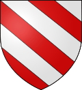 |
The arms of Fournes-en-Weppes are blazoned : Bendy argent and gules. (La Flamengrie, Fournes-en-Weppes and Wargnies-le-Grand use the same arms.) |
See also
References
| Wikimedia Commons has media related to Fournes-en-Weppes. |
.svg.png)
This article is issued from Wikipedia - version of the 11/20/2016. The text is available under the Creative Commons Attribution/Share Alike but additional terms may apply for the media files.