Francisco Sarabia National Airport
Coordinates: 16°33′42″N 093°01′33″W / 16.56167°N 93.02583°W
| Francisco Sarabia National Airport Terán Airport | |||||||||||
|---|---|---|---|---|---|---|---|---|---|---|---|
 | |||||||||||
|
IATA: | |||||||||||
| Summary | |||||||||||
| Airport type | Public / Military | ||||||||||
| Serves | Tuxtla Gutiérrez, Chiapas, México | ||||||||||
| Elevation AMSL | 1,491 ft / 454 m | ||||||||||
| Runways | |||||||||||
| |||||||||||
| Statistics (2005) | |||||||||||
| |||||||||||
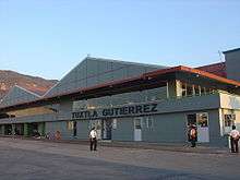
Francisco Sarabia National Airport or Terán Airport (formerly IATA code TGZ, ICAO code MMTG) was a national airport located at Tuxtla Gutiérrez, Chiapas, Mexico. It was used to handle national air traffic for the city of Tuxtla Gutiérrez. As of right now it is closed to civil operations and it is used as Base Aérea Militar No. 6 by the Mexican Air Force. Scheduled airline service for the city is now handled at the new Angel Albino Corzo International Airport, which has taken over Sarabia's former IATA and ICAO airport codes (as of June 2006). It is now used for military purposes only.
202 Air Squadron
The 202 Air Squadron is a Mexican Air Force unit operating out Terán Airport. The unit operates Pilatus PC-9 and Pilatus PC-7 planes.
Incidents
On September 15, 2010, an AeroMexico MD-83 erroneously landed at Teran airport after confusing it with Albino Corzo International Airport. AeroMexico flight 553, operated on behalf of AeroMexico Travel, came from Mexico City and had 80 passengers on board.[3]
References
- ↑ Airport information for MMTG at World Aero Data. Data current as of October 2006.Source: DAFIF.
- ↑ Airport information for TGZ at Great Circle Mapper. Source: DAFIF (effective October 2006).
- ↑ http://avherald.com/h?article=430f5d41&opt=0