Freeman's Grove Historic District
|
Freeman's Grove Historic District | |
|
Bracewell Avenue (2010) | |
  | |
| Location | North Adams, Massachusetts |
|---|---|
| Coordinates | 42°41′41″N 73°6′40″W / 42.69472°N 73.11111°WCoordinates: 42°41′41″N 73°6′40″W / 42.69472°N 73.11111°W |
| Architect | various |
| Architectural style | Colonial Revival, Greek Revival, Late Victorian |
| MPS | North Adams MRA |
| NRHP Reference # | 85003388[1] |
| Added to NRHP | October 25, 1985 |
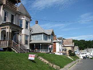
The Freeman's Grove Historic District is a residential historic district in North Adams, Massachusetts. It encompasses a neighborhood north of the city center that is a well-preserved instance of a working class area developed during the its industrial heyday in the late 19th century. It includes all the houses on Bracewell Street, Chase Avenue, and Hall Street, and some houses on Chase Hill and other streets adjacent to those. It is roughly bounded by Liberty Street, Eagle Street, Bracewell Avenues and Houghton Street.[2]
The housing stock in the district includes single- and multiple-family homes, built in a variety of architectural styles. There are only a small number of houses that were built before the boom of the late 19th century, most of which are in a Greek Revival style. Most of the housing in the district was built between 1887 and 1894.[2] The district was listed on the National Register of Historic Places in 1985.[1]
See also
References
- 1 2 National Park Service (2008-04-15). "National Register Information System". National Register of Historic Places. National Park Service.
- 1 2 "NRHP nomination for Freeman's Grove Historic District". Commonwealth of Massachusetts. Retrieved 2013-12-05.
| Topics |  | ||||||||||||||||||||||||||||||
|---|---|---|---|---|---|---|---|---|---|---|---|---|---|---|---|---|---|---|---|---|---|---|---|---|---|---|---|---|---|---|---|
| Lists by county | |||||||||||||||||||||||||||||||
| Lists by city |
| ||||||||||||||||||||||||||||||
| Other lists | |||||||||||||||||||||||||||||||
| |||||||||||||||||||||||||||||||