Frenchman Mountain
| Frenchman Mountain | |
|---|---|
 Frenchman Mountain Area Ranges | |
| Highest point | |
| Elevation | 4,056 ft (1,236 m) NAVD 88[1] |
| Prominence | 1,972 ft (601 m) [2] |
| Coordinates | 36°10′45″N 114°59′51″W / 36.179181253°N 114.997611072°WCoordinates: 36°10′45″N 114°59′51″W / 36.179181253°N 114.997611072°W [1] |
| Geography | |
 Frenchman Mountain
| |
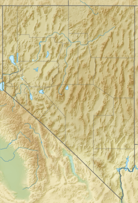
| Location | Clark County, Nevada, U.S. |
| Topo map | USGS Frenchman Mountain, NV |
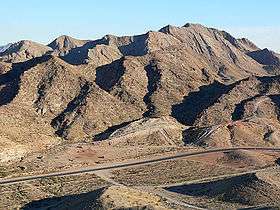
Frenchman Mountain is located east of Las Vegas in the U.S. state of Nevada. Made up of rocks similar to those found on the bottom of the Grand Canyon, Frenchman Mountain formed when faulting elevated and tilted the rocks followed by erosion, giving it its sharp triangular profile. It is the site of the Great Unconformity with the tilted Paleozoic strata underlain by Paleoproterozoic Vishnu Schist, which is some of the oldest rock on the North American continent, having been created about two billion years ago.
The peak lies on a north to north-northeast trending ridge about 2000 feet above the nearby valleys. Sunrise Mountain lies 3.6 miles (5.8 km) to the northeast adjacent to Nellis Air Force Base. The north end of the McCullough Range about 12 miles (19 km) to the south has a parallel trend. The River Mountains lie to the southeast.[3][4] State Route 147 crosses its northern slope. A geologically rich area called Rainbow Gardens is located to its southeast, as is an igneous laccolith, Lava Butte.[5] The Frenchman Mountain Fault poses a significant earthquake danger to the Clark County, Nevada (Las Vegas) region.[6]
It is commonly, and mistakenly, referred to as Sunrise Mountain, the name of a smaller peak to the north of Frenchman Mountain. The area from Cheyenne Avenue and Boulder Highway and Lamb Boulevard is commonly known as Sunrise Manor Township CDP.
References
- 1 2 "Sunrise". NGS data sheet. U.S. National Geodetic Survey. Retrieved 2008-11-22. Note: Though the name of the station is Sunrise it is on Frenchman Mountain.
- ↑ "Frenchman Mountain, Nevada". Peakbagger.com. Retrieved 2008-04-03.
- ↑ Nevada, Delorme Atlas and Gazetteer, 8th ed., 2012, P.70 ISBN 0-89933-334-6
- ↑ Frenchman Mountain, Nevada, 7.5 Minute Topographic Quadrangle, USGS, 1970
- ↑ "Geologic History of Lake Mead National Recreation Area". U.S. Geological Survey. 2007-04-06. Retrieved 2008-01-28.
- ↑ Loss-Estimation Modeling of Earthquake Scenarios for Each County in Nevada Using HAZUS-MH. Frenchman Mountain Fault, M6.6 Earthquake Scenario (p.63); Nevada Bureau of Mines and Geology
External links
- Rowland, S. (nda) Frenchman Mountain Great Unconformity site Department of Geoscience, University of Nevada, Las Vegas, Nevada.
- Rowland, S. (ndb) Geologic Map of Frenchman Mountain Department of Geoscience, University of Nevada, Las Vegas, Nevada.
- Rowland, S. (ndc) Frenchman Mountain and the Great Unconformity. Department of Geoscience, University of Nevada, Las Vegas, Nevada.
- Share, J. (2102a) The Great Unconformity of the Grand Canyon and the Late Proterozoic-Cambrian Time Interval: Part I - Defining It.
- Share, J. (2102a) The Great Unconformity and the Late Proterozoic-Cambrian Time Interval: Part II - The Rifting of Rodinia and the "Snowball Earth" Glaciations That Followed
- Timmons, M. K. Karlstrom, and C. Dehler (1999) Grand Canyon Supergroup Six Unconformities Make One Great Unconformity A Record of Supercontinent Assembly and Disassembly. Boatman's Quarterly Review. vol. 12, no. 1, pp. 29–32.
| Wikimedia Commons has media related to Frenchman Mountain. |
- "Frenchman Mountain". Geographic Names Information System. United States Geological Survey. Retrieved 2008-04-03.