Fresno Dam
| Fresno Dam | |
|---|---|
 Fresno Dam | |
| Country | United States |
| Location | Hill County, Montana |
| Coordinates | 48°36′05″N 109°56′40″W / 48.60139°N 109.94444°WCoordinates: 48°36′05″N 109°56′40″W / 48.60139°N 109.94444°W |
| Construction began | 1937 |
| Opening date | 1939 |
| Dam and spillways | |
| Type of dam | Earthfill |
| Impounds | Milk River |
| Height | 110 ft (34 m) |
| Length | 2,070 ft (630 m) |
| Elevation at crest | 2,596 ft (791 m) |
| Width (crest) | 22 ft (6.7 m) |
| Width (base) | 726 ft (221 m) |
| Dam volume | 2,105,000 cu yd (1,609,000 m3) |
| Spillway type | Uncontrolled over-the-crest |
| Spillway capacity | 51,360 cu ft/s (1,454 m3/s) |
| Reservoir | |
| Creates | Fresno Reservoir |
| Total capacity | 129,062 acre·ft (159,196,000 m3) |
| Surface area | 7,388 acres (2,990 ha) |
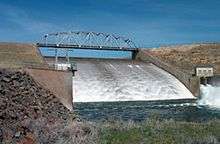
Fresno Dam is a dam on the Milk River, a tributary of the Missouri River, upstream of Havre, Montana. The dam is part of the Milk River Project, owned by the U.S. Bureau of Reclamation. It serves mainly to provide irrigation water and some of its capacity is also reserved for flood control. The dam was built between 1937 and 1939, and raised and overhauled in 1943 and 1951.[1]
References
- ↑ "Fresno Dam". Milk River Project. U.S. Bureau of Reclamation. 2010-08-10. Retrieved 2011-10-28.
This article is issued from Wikipedia - version of the 9/16/2015. The text is available under the Creative Commons Attribution/Share Alike but additional terms may apply for the media files.