Gümüşhane Province
Ü
| Gümüşhane Province Gümüşhane ili | |
|---|---|
| Province of Turkey | |
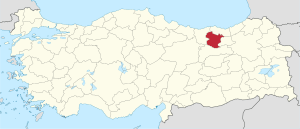 Location of Gümüşhane Province in Turkey | |
| Country | Turkey |
| Region | East Black Sea |
| Subregion | Trabzon |
| Government | |
| • Electoral district | Gümüşhane |
| Area | |
| • Total | 6,575 km2 (2,539 sq mi) |
| Population (2010-12-31)[1] | |
| • Total | 129,618 |
| • Density | 20/km2 (51/sq mi) |
| Area code(s) | 0406 |
| Vehicle registration | 29 |
Gümüşhane Province (Turkish: Gümüşhane ili ) is a province in northern Turkey, bordering Bayburt to the east, Trabzon to the north, Giresun and Erzincan to the west. It covers an area of 6,575 km² and has a population of 129,618 in 2010. The population was 186,953 in 2000. The name Gümüşhane means silver house. The city has a rich mining (silver and bronze) history and was the source of exports for Trabzon.
Geography
Gümüşhane is surrounded by high mountains, Zigana-Trabzon Mountains to the north, Çimen Mountains to the south, Giresun Mountains to the west and Pulur, Soğanlı Mountains to the east. Trekking is popular sport is at these mountains. The Zigana Mountain has a ski center on it and it is a well known touristic place for winter sports. Abdal Musa Peak (3331 m.) is the highest peak within it. The main trees in the forests are Scotch pine and fir, and there are many animals and birds in the area. There are many lakes such as Karanlık Göl, Beş Göller, Artebel Gölü, Kara Göller which are at the peak of Gavurdağı Mountain, and are preserved as natural parks. These all mountains compose 56% of the area of Gümüşhane province.
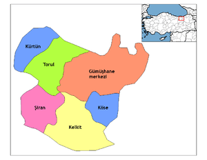
Districts
Gümüşhane province is divided into 6 districts (capital district in bold):
Economy
Historically, the province had silver mines. However, production ceased due to deforestation by 1920.[2]
See also
References
- ↑ Turkish Statistical Institute, MS Excel document – Population of province/district centers and towns/villages and population growth rate by provinces
- ↑ Prothero, W.G. (1920). Armenia and Kurdistan. London: H.M. Stationery Office. p. 73.
External links
| Wikimedia Commons has media related to Gümüşhane Province. |
| ||
Metropolitan municipalities are bolded. | ||
Coordinates: 40°23′17″N 39°25′07″E / 40.38806°N 39.41861°E