GS50 projection
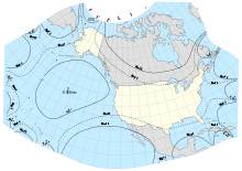
GS-50 projection, with lines of constant scale factor superimposed. All 50 states, including islands and passages between Alaska, Hawaii, and the conterminous 48 states are shown with scale factors ranging only from 1.02 to 0.98
GS50 is a map projection that was developed by John Parr Snyder of the USGS in 1982.
The GS50 projection provides a conformal projection suitable only for maps of the 50 United States. Scale varies less than 2% throughout the area covered. Distortion is very low as well. It is not a standard projection in the sense that it uses complex polynomials (of the tenth order) rather than a trigonometric formulation, though it was developed from an oblique stereographic projection.
References
- Snyder, John Parr (1985). "Computer-assisted map projection research" (Abstract + pdf (74Mb)). Bulletin. United States Geological Survey. 1629: 79–92; 147–51. Retrieved 26 March 2013.
- Snyder, John Parr (1987). "Map Projections: A Working Manual" (Abstract + pdf (22Mb)). Professional Paper. United States Geological Survey. 1395: 203–212. Retrieved 26 March 2013.
This article is issued from Wikipedia - version of the 7/3/2016. The text is available under the Creative Commons Attribution/Share Alike but additional terms may apply for the media files.